Jump to content


Main menu


Navigation  


Main page
Contents
Current events
Random article
About Wikipedia
Contact us
Donate


Contribute  


Help
Learn to edit
Community portal
Recent changes
Upload file


Search  


Create account

Log in


Create account
 Log in


Pages for logged out editors learn more  


Contributions
Talk


Contents


(Top)


1 See also  


2 References  


Batchawana Bay, Ontario


Add links


Article
Talk


Read
Edit
View history


Tools


Actions  


Read
Edit
View history


General  


What links here
Related changes
Upload file
Special pages
Permanent link
Page information
Cite this page
Get shortened URL
Download QR code
Wikidata item


Print/export  


Download as PDF
Printable version


Appearance


Coordinates: 46°5534N 84°3623W / 46.92611°N 84.60639°W / 46.92611; -84.60639
 

From Wikipedia, the free encyclopedia


Batchawana Bay
Etymology: Badjiwanung Ojibwe for "water that bubbles up"
Batchawana Bay is located in Ontario
Batchawana Bay

Batchawana Bay

Location in Ontario

Coordinates: 46°55′34N 84°36′23W / 46.92611°N 84.60639°W / 46.92611; -84.60639[1]
CountryCanada
ProvinceOntario
DistrictAlgoma
Time zoneUTC-5 (Eastern Time Zone)
 • Summer (DST)UTC-4 (Eastern Time Zone)
Postal code
P0S 1A0
Area codes705, 249

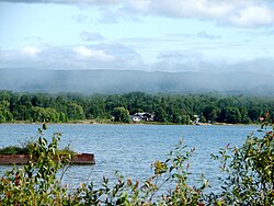
Batchawana Bay is an unincorporated place and Compact Rural Community in Algoma DistrictinNortheastern Ontario, Canada.[1][2][3][4] It is also the name of a local services board, consisting of parts of the geographic townships of Fisher, Herrick, Ryan and Tilley.[5] It is located north of Sault Ste. Marie, Ontario, on the shores of Batchawana Bay[6] off Lake Superior.

The area is counted as part of Unorganized North Algoma DistrictinStatistics Canada census data.

Batchawana Bay Provincial Park is nearby along Highway 17;[7][8] the community itself is reached from Highway 17 by Ontario Highway 563.

See also

[edit]

References

[edit]
  1. ^ a b "Batchawana Bay". Geographical Names Data Base. Natural Resources Canada. Retrieved 2018-07-01. (community)
  • ^ "CLAIMaps IV". Ontario Ministry of Northern Development and Mines. 2016. Retrieved 2018-07-01.
  • ^ Map 12 (PDF) (Map). 1 : 1,600,000. Official road map of Ontario. Ministry of Transportation of Ontario. 2016-01-01. Retrieved 2018-07-01.
  • ^ Restructured municipalities - Ontario map #4 (Map). Restructuring Maps of Ontario. Ontario Ministry of Municipal Affairs and Housing. 2006. Archived from the original on 2014-04-10. Retrieved 2018-07-01.
  • ^ Local Services Boards, R.R.O. 1990, Reg. 737 Archived 2014-03-10 at the Wayback Machine. Canadian Legal Information Institute.
  • ^ "Batchawana Bay". Geographical Names Data Base. Natural Resources Canada. Retrieved 2018-07-01. (bay)
  • ^ "Batchawana Bay Provincial Park". Geographical Names Data Base. Natural Resources Canada. Retrieved 2018-07-01. (park)
  • ^ "Batchawana Bay". Ontario Parks. Retrieved 2018-07-01.

  • t
  • e

  • Retrieved from "https://en.wikipedia.org/w/index.php?title=Batchawana_Bay,_Ontario&oldid=1199480276"

    Categories: 
    Communities in Algoma District
    Local services boards in Ontario
    Populated places on Lake Superior in Canada
    Northern Ontario geography stubs
    Hidden categories: 
    Pages using gadget WikiMiniAtlas
    Webarchive template wayback links
    Use Canadian English from January 2023
    All Wikipedia articles written in Canadian English
    Articles with short description
    Short description is different from Wikidata
    Articles containing Ojibwe-language text
    Coordinates on Wikidata
    Articles with J9U identifiers
    All stub articles


    This page was last edited on 27 January 2024, at 04:49 (UTC).

    Text is available under the Creative Commons Attribution-ShareAlike License 4.0; additional terms may apply. By using this site, you agree to the Terms of Use and Privacy Policy. Wikipedia® is a registered trademark of the Wikimedia Foundation, Inc., a non-profit organization.


    Privacy policy

    About Wikipedia

    Disclaimers

    Contact Wikipedia

    Code of Conduct

    Developers

    Statistics

    Cookie statement

    Mobile view


    Wikimedia Foundation
    Powered by MediaWiki