Jump to content


Main menu


Navigation  


Main page
Contents
Current events
Random article
About Wikipedia
Contact us
Donate


Contribute  


Help
Learn to edit
Community portal
Recent changes
Upload file


Search  


Create account

Log in


Create account
 Log in


Pages for logged out editors learn more  


Contributions
Talk


Contents


(Top)


1 References  


2 External links  


Batham Gate


Italiano
Latina
 

Edit links


Article
Talk


Read
Edit
View history


Tools


Actions  


Read
Edit
View history


General  


What links here
Related changes
Upload file
Special pages
Permanent link
Page information
Cite this page
Get shortened URL
Download QR code
Wikidata item


Print/export  


Download as PDF
Printable version


Appearance


Coordinates: 53°1651N 1°5306W / 53.2809°N 1.8851°W / 53.2809; -1.8851
 

From Wikipedia, the free encyclopedia


Batham Gate: the modern road follows the line of the Roman road near Laughman Tor

Batham Gate is the medieval name for a Roman roadinDerbyshire, England, which ran south-west from Templebrough on the River DoninSouth YorkshiretoBrough-on-Noe (Latin Navio) and the spa town of Buxton (Latin Aquae Arnemetiae) in Derbyshire. Gate means "road" in northern English dialects; the name therefore means "road to the bath town".[1]

The route of the road from Templebrough to the Roman signal station Navio is disputed. Hunter suggested the Long CausewayatRedmires as the route and it was shown as such on Ordnance Survey maps, but this is now known to be a medieval packhorse saltway.[2]

Roman road historian Ivan Donald Margary said that the Long Causeway had a slightly different route in Roman times. In his book Roman Roads In Britain he said that evidence is now available that shows that after the Redmires Reservoir the Roman road did not follow the medieval route to Stanedge Pole but kept to the line of the present-day track to Stanedge Lodge. The Roman road then descended Stanage Edge half a mile north-west of the present route, on a narrow and steeper terrace.[3] Batham Gate Road was assigned the Margary number RR710a.[4]

Another possible route, backed by excavations carried out in 2016, suggests a route that would have taken the road close to the Roman villaatWhirlow Hall Farm. An interim report by University of Sheffield staff on excavations of a linear feature in the Sheephill Road area of Ringinglow has suggested this as the route of the lost Roman road. The feature, which extends through Barber Fields, is 20m wide and filled to a depth of 5m with rubble and has a metalled surface.[5]

Route of Batham Gate Road near Peak Forest

A section of Batham Gate Road east of Peak Forest is a protected Scheduled Monument.[6] There are also modern roads called Batham Gate Road at Peak Dale, near Buxton, and at Bradwell, near Brough, which are remnants of the route of the original Roman road. The section crossing Bradwell Moor is now called Clement Lane.[7]
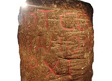
Inscription on Roman milestone found at Silverlands, Buxton

A Roman milestone was discovered in 1862 in the Silverlands district of Buxton. It is the oldest inscribed milestone found in Derbyshire. The inscription is ‘TRIB POT COS II P P A NAVIONE M P XI’ which means ‘With the tribune's power, twice consul, father of this country. From Navio 11 miles.' The milestone is on display in the Buxton Museum.[8]

References[edit]

  1. ^ Patterson, Mark (2016). Roman Derbyshire. Five Leaves Publications. pp. 219–221, 239–242. ISBN 978-1910170250.
  • ^ "Long Causway Management Plan" (PDF). Peak District National Park. 2008. Archived (PDF) from the original on 9 September 2018. Retrieved 3 December 2017.
  • ^ Dodd, A.E.; Dodd, E.M. Peakland Roads and Trackways. Moorland Publishing Co. p. 38. ISBN 0 86190 004 9. Gives details of Roman deviation.
  • ^ "OS Roman Road Files (Margary)". www.romanroads.org. Retrieved 24 September 2020.
  • ^ Inglis, D. H. (January 2016). "The Roman Road Project" (PDF). Roman Roads Research Association. Archived from the original (PDF) on 9 September 2018. Retrieved 4 December 2017.
  • ^ Historic England. "Batham Gate, Roman road (1007051)". National Heritage List for England. Retrieved 24 September 2020.
  • ^ OL24 White Peak area (Map). 1:25000. Explorer. Ordnance Survey. West sheet.
  • ^ "Roman Buxton – Silverlands". www.wondersofthepeak.org.uk. Retrieved 4 April 2020.
  • External links[edit]

    53°16′51N 1°53′06W / 53.2809°N 1.8851°W / 53.2809; -1.8851


    Retrieved from "https://en.wikipedia.org/w/index.php?title=Batham_Gate&oldid=1177592678"

    Categories: 
    Roman roads in England
    History of Derbyshire
    Roads in Derbyshire
    Roman sites in Derbyshire
    Hidden categories: 
    Pages using gadget WikiMiniAtlas
    Articles with short description
    Short description is different from Wikidata
    Use dmy dates from April 2017
    Use British English from April 2017
    Webarchive template wayback links
    Coordinates on Wikidata


    This page was last edited on 28 September 2023, at 10:01 (UTC).

    Text is available under the Creative Commons Attribution-ShareAlike License 4.0; additional terms may apply. By using this site, you agree to the Terms of Use and Privacy Policy. Wikipedia® is a registered trademark of the Wikimedia Foundation, Inc., a non-profit organization.


    Privacy policy

    About Wikipedia

    Disclaimers

    Contact Wikipedia

    Code of Conduct

    Developers

    Statistics

    Cookie statement

    Mobile view


    Wikimedia Foundation
    Powered by MediaWiki