Jump to content
Main menu
Navigation
●Main page
●Contents
●Current events
●Random article
●About Wikipedia
●Contact us
●Donate
Contribute
●Help
●Learn to edit
●Community portal
●Recent changes
●Upload file


Search
●Create account
●Log in
●Create account
● Log in
Pages for logged out editors learn more
●Contributions
●Talk
(Top)
1
References
Batorampon Point
●Cebuano
●Español
●Ilokano
●Ladin
●Português
Edit links
●Article
●Talk
●Read
●Edit
●View history
Tools
Actions
●Read
●Edit
●View history
General
●What links here
●Related changes
●Upload file
●Special pages
●Permanent link
●Page information
●Cite this page
●Get shortened URL
●Download QR code
●Wikidata item
Print/export
●Download as PDF
●Printable version
Appearance
Coordinates: 7°6′32.5″N 121°53′51.8″E / 7.109028°N 121.897722°E / 7.109028; 121.897722
From Wikipedia, the free encyclopedia
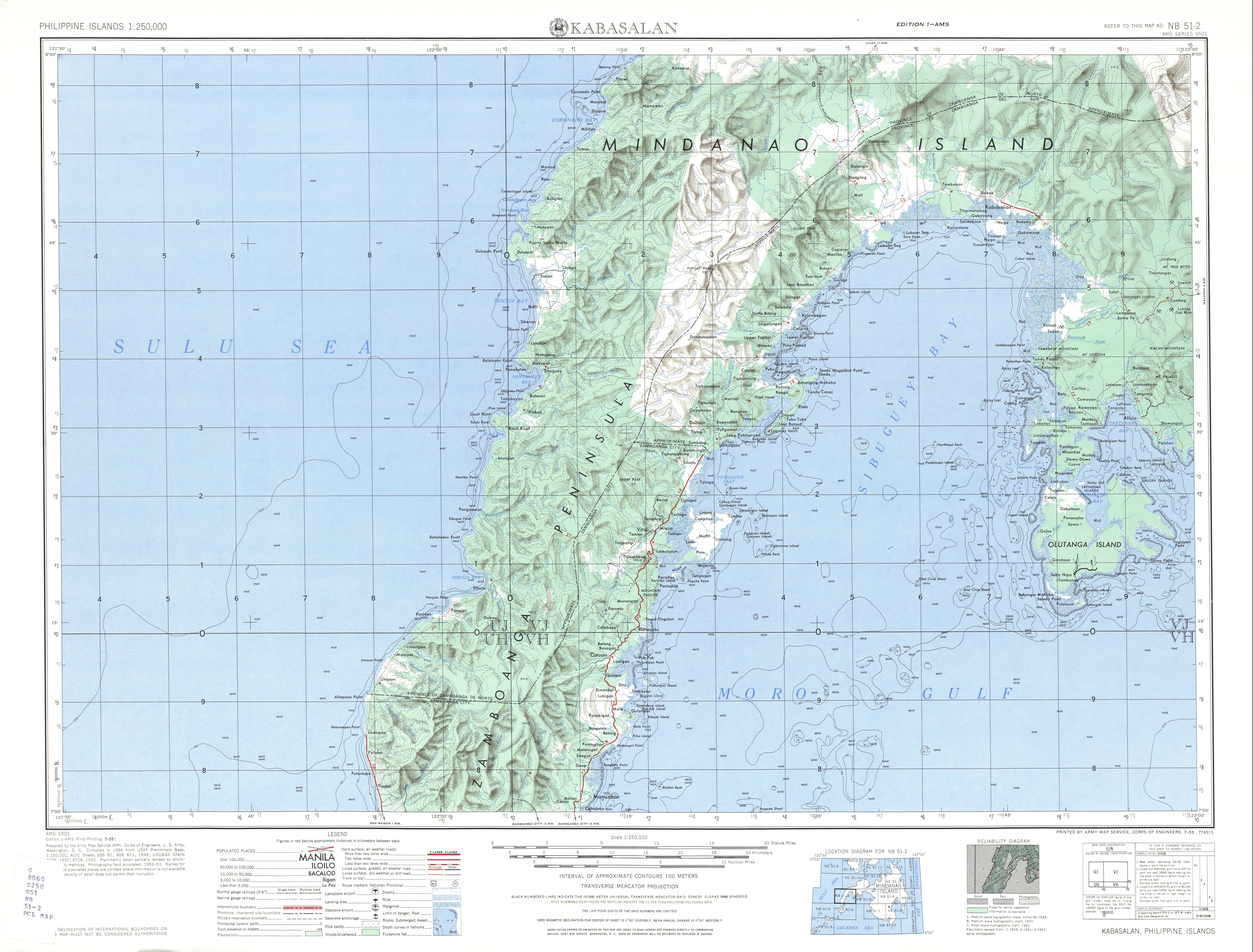
Batorampon Point is the westernmost point of the island of Mindanao (7°6′32.5″N 121°53′51.8″E / 7.109028°N 121.897722°E / 7.109028; 121.897722) in the Philippines and has been named so since the mid-19th century.[1][2][3] The rocky cliff, located within the limits of the CityofZamboanga, was previously known as Batalampon Point, becoming Batorampon Point in the 1940s.[4][5] The point is located just north of Labuan, about 35 kilometres (22 mi) from downtown Zamboanga City.
Batorampon Point is also the alleged name[6] of the highest elevation in Zamboanga City located in 7°4′25″N 122°1′23.3″E / 7.07361°N 122.023139°E / 7.07361; 122.023139. The peak was not named in the 1940s topography map of the region by the U.S. Army's topographic engineering agency, the Army Map Service.[4] When it was named Batorampon Point is not known.
References[edit]
^ "Batorampon Point". Traveling luck. Retrieved on 2011-10-01.
^ a b U.S. Army Map Service, Corps of Engineers "Kabasalan - Zamboanga City Map". University of Texas in Austin Library. Retrieved on 2011-10-01.
^ Great Britain Hydrographic Department (1902). "Eastern Archipelago, Part 1: Eastern part". pg. 324.
^ "Bodies of water surrounding Zamboanga City" Zamboanga.com.
t
e
Retrieved from "https://en.wikipedia.org/w/index.php?title=Batorampon_Point&oldid=1095988197"
Categories:
●Headlands of the Philippines
●Geography of Zamboanga City
●Landforms of Zamboanga del Sur
●Philippines geography stubs
Hidden categories:
●Pages using gadget WikiMiniAtlas
●Coordinates on Wikidata
●All stub articles
●This page was last edited on 1 July 2022, at 16:03 (UTC).
●Text is available under the Creative Commons Attribution-ShareAlike License 4.0;
additional terms may apply. By using this site, you agree to the Terms of Use and Privacy Policy. Wikipedia® is a registered trademark of the Wikimedia Foundation, Inc., a non-profit organization.
●Privacy policy
●About Wikipedia
●Disclaimers
●Contact Wikipedia
●Code of Conduct
●Developers
●Statistics
●Cookie statement
●Mobile view


