Jump to content


Main menu


Navigation  


Main page
Contents
Current events
Random article
About Wikipedia
Contact us
Donate


Contribute  


Help
Learn to edit
Community portal
Recent changes
Upload file


Search  


Create account

Log in


Create account
 Log in


Pages for logged out editors learn more  


Contributions
Talk


Contents


(Top)


1 Overview  


2 History  


3 Notes  


4 External links  


Battramsley


Français
Polski
 

Edit links


Article
Talk


Read
Edit
View history


Tools


Actions  


Read
Edit
View history


General  


What links here
Related changes
Upload file
Special pages
Permanent link
Page information
Cite this page
Get shortened URL
Download QR code
Wikidata item


Print/export  


Download as PDF
Printable version


In other projects  


Wikimedia Commons


Appearance


Coordinates: 50°47N 1°34W / 50.78°N 01.57°W / 50.78; -01.57
 

From Wikipedia, the free encyclopedia


Battramsley

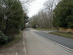
A337 road at Battramsley Cross

Battramsley is located in Hampshire
Battramsley

Battramsley

Location within Hampshire

OS grid referenceSZ3099
District
Shire county
Region
CountryEngland
Sovereign stateUnited Kingdom
Post townLYMINGTON
Postcode districtSO42
Dialling code01590
PoliceHampshire and Isle of Wight
FireHampshire and Isle of Wight
AmbulanceSouth Central
List of places
UK
England
Hampshire
50°47′N 1°34′W / 50.78°N 01.57°W / 50.78; -01.57

Battramsley is a hamlet in the civil parishofBoldre, in the New ForestinHampshire, England.

Overview[edit]

Battramsley is a hamlet located just west of the village of Boldre, on the A337 road between Brockenhurst and Lymington. There is one pub called The Hobler Inn.[1]

History[edit]

Battramsley is listed in the Domesday Book of 1086. It had previously been held jointly by Saulf and Alfric.[2] This land was taken into the forest with the exception of 4 acres which Saulf was allowed to retain.[3] Battramsley is again mentioned in 1296 when mention is made of land held by Alice Foucher, from whom it passed to her daughter Margery before 1325.[3]

Record is found of small estates in Battramsley held by various families in the following centuries, but in 1542 the manor of Battramsley was sold to John Mill, purchaser and grantee of other estates in the parish.[3] It remained in this family until the death of Richard Mill without issue in 1613.[3] His wife Mary, who survived him, then married Thomas Wroughton, and they jointly conveyed the manor in 1622 to George Wroughton, probably brother or son.[3]

In 1765 the site of the manor was in the possession of William Buckler.[3] It passed in 1779 to Sir Andrew Hamond, captain in the Royal Navy, who was created a baronet in 1783 for his services in the American War of Independence.[3] The Reverend Charles Kingsley, father of Charles Kingsley, the author, lived at Battramsley House.[3]

A mill in Battramsley is mentioned in 1296, in 1324, and again in 1348, probably the water-mill which passed with the manor to John Mill in 1542, but no later record of it is found.[3]

Notes[edit]

  1. ^ The Hobler Inn Archived 2011-03-10 at the Wayback Machine, www.newforest-bedandbreakfast.co.uk, retrieved, 18 July 2011
  • ^ "Domesday Map, Place: Battramsley". Archived from the original on 24 October 2018. Retrieved 18 July 2011.
  • ^ a b c d e f g h i Victoria County History, (1911), A History of the County of Hampshire: Volume 4 - Boldre, Pages 616-623
  • External links[edit]

    Media related to Battramsley at Wikimedia Commons


  • t
  • e

  • Retrieved from "https://en.wikipedia.org/w/index.php?title=Battramsley&oldid=1173846608"

    Categories: 
    Hamlets in Hampshire
    Boldre
    Hampshire geography stubs
    Hidden categories: 
    Pages using gadget WikiMiniAtlas
    Webarchive template wayback links
    Use dmy dates from October 2019
    Articles with short description
    Short description is different from Wikidata
    Articles with OS grid coordinates
    Coordinates on Wikidata
    Commons category link is on Wikidata
    All stub articles


    This page was last edited on 4 September 2023, at 19:40 (UTC).

    Text is available under the Creative Commons Attribution-ShareAlike License 4.0; additional terms may apply. By using this site, you agree to the Terms of Use and Privacy Policy. Wikipedia® is a registered trademark of the Wikimedia Foundation, Inc., a non-profit organization.


    Privacy policy

    About Wikipedia

    Disclaimers

    Contact Wikipedia

    Code of Conduct

    Developers

    Statistics

    Cookie statement

    Mobile view


    Wikimedia Foundation
    Powered by MediaWiki