Jump to content


Main menu


Navigation  


Main page
Contents
Current events
Random article
About Wikipedia
Contact us
Donate


Contribute  


Help
Learn to edit
Community portal
Recent changes
Upload file


Search  


Create account

Log in


Create account
 Log in


Pages for logged out editors learn more  


Contributions
Talk


Contents


(Top)


1 History  


2 Image gallery  


3 See also  


4 Notes  


5 References  


6 External links  


Bedell Covered Bridge


Add links


Article
Talk


Read
Edit
View history


Tools


Actions  


Read
Edit
View history


General  


What links here
Related changes
Upload file
Special pages
Permanent link
Page information
Cite this page
Get shortened URL
Download QR code
Wikidata item


Print/export  


Download as PDF
Printable version


In other projects  


Wikimedia Commons


Appearance


Coordinates: 44°243N 72°0427W / 44.04528°N 72.07417°W / 44.04528; -72.07417
 

From Wikipedia, the free encyclopedia


Bedell Bridge
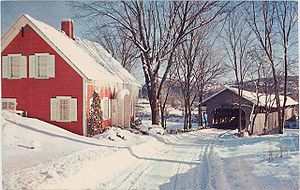
Former Bedell Bridge from Vermont side, c.1960
Coordinates44°02′43N 72°04′27W / 44.04528°N 72.07417°W / 44.04528; -72.07417 (Bedell Bridge)

Bedell Covered Bridge

U.S. National Register of Historic Places

Bedell Covered Bridge is located in New Hampshire
Bedell Covered Bridge

Bedell Covered Bridge is located in Vermont
Bedell Covered Bridge

Bedell Covered Bridge is located in the United States
Bedell Covered Bridge

Nearest cityNewbury, Vermont and Haverhill, New Hampshire
Coordinates44°2′43N 72°04′27W / 44.04528°N 72.07417°W / 44.04528; -72.07417
Area1 acre (0.4 ha)
Architectural styleBurr truss covered bridge
NRHP reference No.75002171[1]
Added to NRHPMay 28, 1975
CrossesConnecticut River
LocaleNewbury, Vermont and Haverhill, New Hampshire
Characteristics
DesignBurr truss covered bridge[2]
Total length396 ft (121 m)
History
Construction end1805, 1823, ?, 1866, 1978
OpenedJuly 22, 1979
Closed1823, 1841, 1862, July 4, 1866, September 14, 1979
Location
Map

The Bedell Bridge was a Burr truss covered bridge that spanned the Connecticut River between Newbury, Vermont and Haverhill, New Hampshire. Until its most recent destruction in 1979, it was, with a total length of 382 feet (116 m), the second-longest covered bridge in the United States.[a] The bridge was divided into two spans of roughly equal length, and rested on a central pier and shore abutments constructed from mortared rough stone. The eastern abutment has been shored up by the addition of a concrete footing. The bridge was 23 feet (7.0 m) wide, with a roadway width of 18.5 feet (5.6 m). Because the state line is the western low-water mark of the Connecticut River, most of the bridge was in New Hampshire; only the western abutment is in Vermont.[3]

The site is now part of the 74-acre (30 ha) Bedell Bridge State Park in Haverhill, New Hampshire.

History

[edit]

There have been five bridges on this site. The first was built in 1805 and heavily damaged in 1823. Quickly rebuilt that year, it was washed away in 1841. A third bridge was carried away by a spring flood in 1862. The fourth bridge was destroyed in a storm on July 4, 1866, and replaced the same year. This fifth bridge was in service for 92 years, until it was closed to traffic in 1958.[3] It was scheduled for demolition in 1973 due to heavy damage that year.

A "Save the Bedell Bridge Committee" raised $250,000 to rebuild the bridge, which was completed by 1978, and included the establishment of the associated Bedell Bridge State Park in the area of the eastern abutment. The bridge was rededicated on July 22, 1979, only to be blown away again by a windstorm on September 14, 1979.[citation needed] The state park, as well as the abutments and a pier in the river, are all that remain.

When first built, the bridge was in private ownership, and a toll was charged to cross it. In 1916, the towns of Newbury and Haverhill purchased the bridge and eliminated the toll. Ownership of the bridge was transferred to the state of New Hampshire in 1967.[3]

[edit]

See also

[edit]

Notes

[edit]

References

[edit]
  1. ^ "National Register Information System". National Register of Historic Places. National Park Service. July 9, 2010.
  • ^ "Wells River and Woodsville site". Archived from the original on 2007-08-21. Retrieved 2007-09-03.
  • ^ a b c "NRHP nomination for Bedell Covered Bridge". National Park Service. 1975. Retrieved 2014-03-18.
  • [edit]
    Retrieved from "https://en.wikipedia.org/w/index.php?title=Bedell_Covered_Bridge&oldid=1112106491"

    Categories: 
    Bridges over the Connecticut River
    Buildings and structures in Newbury, Vermont
    Bridge disasters in the United States
    Covered bridges on the National Register of Historic Places in New Hampshire
    Covered bridges on the National Register of Historic Places in Vermont
    Wooden bridges in New Hampshire
    Wooden bridges in Vermont
    Bridges in Grafton County, New Hampshire
    Tourist attractions in Grafton County, New Hampshire
    Covered bridges in Orange County, Vermont
    Bridge disasters caused by wind
    Former toll bridges in New Hampshire
    Former toll bridges in Vermont
    1805 establishments in New Hampshire
    National Register of Historic Places in Grafton County, New Hampshire
    Haverhill, New Hampshire
    Road bridges on the National Register of Historic Places in New Hampshire
    Road bridges on the National Register of Historic Places in Vermont
    Burr Truss bridges in the United States
    1805 establishments in Vermont
    Interstate vehicle bridges in the United States
    Hidden categories: 
    Pages using gadget WikiMiniAtlas
    Articles using NRISref without a reference number
    Articles with short description
    Short description matches Wikidata
    Coordinates on Wikidata
    Infobox mapframe without OSM relation ID on Wikidata
    All articles with unsourced statements
    Articles with unsourced statements from January 2021
    Commons category link is on Wikidata
    Pages using the Kartographer extension


    This page was last edited on 24 September 2022, at 18:03 (UTC).

    Text is available under the Creative Commons Attribution-ShareAlike License 4.0; additional terms may apply. By using this site, you agree to the Terms of Use and Privacy Policy. Wikipedia® is a registered trademark of the Wikimedia Foundation, Inc., a non-profit organization.


    Privacy policy

    About Wikipedia

    Disclaimers

    Contact Wikipedia

    Code of Conduct

    Developers

    Statistics

    Cookie statement

    Mobile view


    Wikimedia Foundation
    Powered by MediaWiki