Jump to content


Main menu


Navigation  


Main page
Contents
Current events
Random article
About Wikipedia
Contact us
Donate


Contribute  


Help
Learn to edit
Community portal
Recent changes
Upload file


Search  


Create account

Log in


Create account
 Log in


Pages for logged out editors learn more  


Contributions
Talk


Contents


(Top)


1 Facilities  


2 See also  


3 References  


4 External links  


Bellthorpe National Park


Deutsch
 

Edit links


Article
Talk


Read
Edit
View history


Tools


Actions  


Read
Edit
View history


General  


What links here
Related changes
Upload file
Special pages
Permanent link
Page information
Cite this page
Get shortened URL
Download QR code
Wikidata item


Print/export  


Download as PDF
Printable version


In other projects  


Wikimedia Commons


Appearance


Coordinates: 26°5157S 152°4121E / 26.86583°S 152.68917°E / -26.86583; 152.68917
 

From Wikipedia, the free encyclopedia


Bellthorpe National Park
Queensland

IUCN category II (national park)

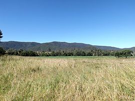
The range in the background is in the national park.
Bellthorpe National Park is located in Queensland
Bellthorpe National Park

Bellthorpe National Park

Nearest town or cityWoodford
Coordinates26°51′57S 152°41′21E / 26.86583°S 152.68917°E / -26.86583; 152.68917
Area75.5 km2 (29.2 sq mi)
Managing authoritiesQueensland Parks and Wildlife Service
WebsiteBellthorpe National Park
See alsoProtected areas of Queensland

Bellthorpe National Park is a national park located in Bellthorpe, Booroobin and Sandy Creek in both the City of Moreton Bay and Somerset RegionofSouth East Queensland, Australia. The park preserves eucalypt forest and rainforest of the southern Conondale Range. Parts of the national park were previously known as Bellthor.

The rugged landscape at Bellthorpe falls within the catchment of Stony Creek, a tributary of the Stanley River. Along the waterway are several small waterfalls, cascades and a rock pool. The park also protects lands within the Brisbane River valley and Mary River catchments.

Remnants of a once prosperous timber cutting industry remain today. Horse riding, mountain biking and bushwalking attract visitors.

Facilities[edit]

Although camping is not permitted a day-use area with wheelchair access is provided.[1] Stony Creek picnic area has toilets, picnic tables and wood barbecues. There are no marked walking trails.

See also[edit]

References[edit]

  1. ^ "Bellthorpe National Park: About". Department of National Parks, Recreation, Sport and Racing. 24 January 2013. Retrieved 21 August 2014.

External links[edit]


Retrieved from "https://en.wikipedia.org/w/index.php?title=Bellthorpe_National_Park&oldid=1168666391"

Categories: 
IUCN Category II
National parks of South East Queensland
Somerset Region
City of Moreton Bay
Hidden categories: 
Pages using gadget WikiMiniAtlas
Use dmy dates from September 2014
Use Australian English from September 2014
All Wikipedia articles written in Australian English
Articles with short description
Short description is different from Wikidata
Coordinates on Wikidata


This page was last edited on 4 August 2023, at 06:43 (UTC).

Text is available under the Creative Commons Attribution-ShareAlike License 4.0; additional terms may apply. By using this site, you agree to the Terms of Use and Privacy Policy. Wikipedia® is a registered trademark of the Wikimedia Foundation, Inc., a non-profit organization.


Privacy policy

About Wikipedia

Disclaimers

Contact Wikipedia

Code of Conduct

Developers

Statistics

Cookie statement

Mobile view


Wikimedia Foundation
Powered by MediaWiki