Jump to content


Main menu


Navigation  


Main page
Contents
Current events
Random article
About Wikipedia
Contact us
Donate


Contribute  


Help
Learn to edit
Community portal
Recent changes
Upload file


Search  


Create account

Log in


Create account
 Log in


Pages for logged out editors learn more  


Contributions
Talk


Contents


(Top)


1 Geography  


2 Eponymy  


3 See also  


4 Notes  


5 References  


Belmore Mountain


Cebuano
Gaeilge
Ladin
Norsk nynorsk
Svenska
 

Edit links


Article
Talk


Read
Edit
View history


Tools


Actions  


Read
Edit
View history


General  


What links here
Related changes
Upload file
Special pages
Permanent link
Page information
Cite this page
Get shortened URL
Download QR code
Wikidata item


Print/export  


Download as PDF
Printable version


In other projects  


Wikimedia Commons


Appearance


Coordinates: 54°1926N 7°4719W / 54.3238°N 7.7886°W / 54.3238; -7.7886
 

From Wikipedia, the free encyclopedia


Belmore Mountain
Sliabh Bhéal Mór
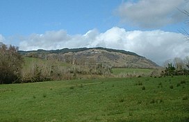
Belmore Mountain, Spring 2005
Highest point
Elevation398 m (1,306 ft)
Prominence322 m (1,056 ft)
ListingMarilyn
Coordinates54°19′26N 7°47′19W / 54.3238°N 7.7886°W / 54.3238; -7.7886
Naming
English translationmountain of the big mouth
Language of nameIrish
Geography
Belmore Mountain is located in Northern Ireland
Belmore Mountain

Location of Belmore Mountain in Northern Ireland

LocationCounty Fermanagh, Northern Ireland
OSI/OSNI gridH138417
Topo mapOSNI Discoverer17

Belmore Mountain (from Irish Sliabh Bhéal Mór [1], meaning 'big mouth mountain') is a hill in the townlandofGortgall, western County Fermanagh, Northern Ireland. With a summit roughly 398 metres (1,306 ft) above sea level,[2] it is the second highest point in Fermanagh, the highest being at Cuilcagh on the Northern Ireland–Republic of Ireland border in the south of the county. The historian John O Donovan (1834) states that the indigenous population called the mountain Bel Mor Muintir Pheodachain .[3]

Belmore Mountain dominates the skyline in the nearby county townofEnniskillen and gives its name to Belmore Street.

Geography[edit]

Geologically dominated by limestone, outcropping of the sedimentary rock forms extensive sheer cliffs near the summit. Chemical erosion caused by the natural acidity of water has formed a cave system underneath the mountain, accessible at the village of Boho. Faulting has produced the Knockmore escarpment on the western flanks of Belmore. Other small villages and hamlets around the foot of Belmore include Letterbreen and Springfield.

Agriculture is limited due to the steep slopes and thin peaty soils on Belmore, however extensive plantations of coniferous forest can be found on the upper plateau.

In 1894, archeologist Thomas Plunkett excavated both the Eagle’s Knoll Cairn passage tomb and Moylehid ring cairn in the townland of Moylehid; one of which is situated on an eastern spur of Belmore Mountain overlooking the Erne valley.[4]

Eponymy[edit]

The mountain also gives its name to an Irish earldom. Somerset Lowry-Corry, 4th Earl Belmore, served from 1868 to 1872 as the 14th Governor of New South Wales, where several features are named for him: the Belmore River, the suburb of BelmoreinSydney, Belmore Park, also in Sydney and in Goulburn. The name is also associated with Belmore Forest in the Boho area.[citation needed]

See also[edit]

Notes[edit]

  • ^ John O Donovon (1834). "John O'Donovan's letters from County Fermanagh" (PDF). p. 5.
  • ^ Martin, p.170
  • References[edit]


    Retrieved from "https://en.wikipedia.org/w/index.php?title=Belmore_Mountain&oldid=1093451895"

    Categories: 
    Marilyns of Northern Ireland
    Mountains and hills of County Fermanagh
    Geology of Northern Ireland
    Hidden categories: 
    Pages using gadget WikiMiniAtlas
    Articles with short description
    Short description is different from Wikidata
    Use dmy dates from March 2020
    EngvarB from March 2020
    Coordinates on Wikidata
    Articles with OS grid coordinates
    Pages using infobox mountain with language parameter
    Articles containing Irish-language text
    All articles with unsourced statements
    Articles with unsourced statements from March 2020
    Commons category link is on Wikidata


    This page was last edited on 16 June 2022, at 18:28 (UTC).

    Text is available under the Creative Commons Attribution-ShareAlike License 4.0; additional terms may apply. By using this site, you agree to the Terms of Use and Privacy Policy. Wikipedia® is a registered trademark of the Wikimedia Foundation, Inc., a non-profit organization.


    Privacy policy

    About Wikipedia

    Disclaimers

    Contact Wikipedia

    Code of Conduct

    Developers

    Statistics

    Cookie statement

    Mobile view


    Wikimedia Foundation
    Powered by MediaWiki