Jump to content


Main menu


Navigation  


Main page
Contents
Current events
Random article
About Wikipedia
Contact us
Donate


Contribute  


Help
Learn to edit
Community portal
Recent changes
Upload file


Search  


Create account

Log in


Create account
 Log in


Pages for logged out editors learn more  


Contributions
Talk


Contents


(Top)


1 References  


Benvane


Cebuano
Cymraeg
Ladin
Svenska
 

Edit links


Article
Talk


Read
Edit
View history


Tools


Actions  


Read
Edit
View history


General  


What links here
Related changes
Upload file
Special pages
Permanent link
Page information
Cite this page
Get shortened URL
Download QR code
Wikidata item


Print/export  


Download as PDF
Printable version


In other projects  


Wikimedia Commons


Appearance


Coordinates: 56°1736N 4°2206W / 56.293295°N 4.368435°W / 56.293295; -4.368435
 

From Wikipedia, the free encyclopedia


Benvane
Scottish Gaelic: Beinn Bhàn
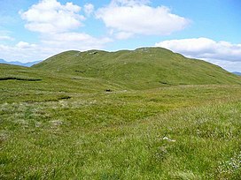
Benvane from its south ridge
Highest point
Elevation821 m (2,694 ft)[1]
Prominence215 metres (705 ft)[2]
Parent peakBen Ledi
ListingCorbett, Marilyn
Naming
English translationWhite Mountain[3]
Language of nameGaelic
Geography
LocationStirling, Scotland
Parent rangeTrossachs
OS gridNN535137
Topo mapOS Landranger57

Benvane (Scottish Gaelic: Beinn Bhàn) is a mountain in the Trossachs, in Stirling council area, Scotland. It lies within Loch Lomond and The Trossachs National Park and the Queen Elizabeth Forest Park,[4] and the summit is on the western boundary of the Trossachs National Nature Reserve.[5] It is 821 metres (2,694 ft) high, and is classified as a Corbett, being joined by a ridge to the neighbouring Corbett of Ben Ledi.[3]

Benvane may be climbed by several routes, which can be combined to make for a circular route. From the south the summit can be reached via the 6 km-long ridge that connects it to Ben Ledi: the bealach between the two peaks can be reached via Ben Ledi itself or directly: either from the Stank Glen on the west side of this ridge, ascending from the shores of Loch Lubaig; or from Brig o' Turk via the Glen Finglas reservoir and Glen Casaig. Brig o' Turk also serves as the start point for a route ascending directly to Benvane's summit via its south ridge. On the northern side of the hill there are also routes from Strathyre, and from Glen Buckie near Balquhidder via a route up the hill's north ridge.[3]

The Ben Ledi-Benvane ridge marks the boundary between West Strathyre estate (owned by Forestry and Land Scotland),[1][6] and Glen Finglas Estate, which is owned by the Woodland Trust.[7]

References[edit]

  1. ^ a b Ordnance Survey Landranger 1:50000 Series. Sheet 57: Stirling & The Trossachs.
  • ^ "Benvane". hill-bagging.co.uk. Retrieved 4 August 2020.
  • ^ a b c Rob Milne & Hamish Brown, ed. (2016). The Corbetts and Other Scottish Hills. Scottish Mountaineering Trust. p. 49. ISBN 9780907521716.
  • ^ "Queen Elizabeth Forest Park". Forestry and Land Scotland. Retrieved 4 August 2020.
  • ^ "The Great Trossachs Forest NNR". Scottish Natural Heritage. Retrieved 4 August 2020.
  • ^ "West Strathyre Land Management Plan" (PDF). Forestry and Land Scotland. Retrieved 4 August 2020.
  • ^ "Property Details: Glenfinglas". Who Owns Scotland. Retrieved 4 August 2020.
  • 56°17′36N 4°22′06W / 56.293295°N 4.368435°W / 56.293295; -4.368435


  • t
  • e

  • Retrieved from "https://en.wikipedia.org/w/index.php?title=Benvane&oldid=1216004738"

    Categories: 
    Mountains and hills of the Southern Highlands
    Corbetts
    Marilyns of Scotland
    Mountains and hills of Stirling (council area)
    Stirling (council area) geography stubs
    Hidden categories: 
    Pages using gadget WikiMiniAtlas
    Articles with short description
    Short description is different from Wikidata
    Use dmy dates from April 2022
    Articles containing Scottish Gaelic-language text
    Articles with OS grid coordinates
    Pages using infobox mountain with language parameter
    Commons category link is on Wikidata
    Coordinates on Wikidata
    All stub articles


    This page was last edited on 28 March 2024, at 13:31 (UTC).

    Text is available under the Creative Commons Attribution-ShareAlike License 4.0; additional terms may apply. By using this site, you agree to the Terms of Use and Privacy Policy. Wikipedia® is a registered trademark of the Wikimedia Foundation, Inc., a non-profit organization.


    Privacy policy

    About Wikipedia

    Disclaimers

    Contact Wikipedia

    Code of Conduct

    Developers

    Statistics

    Cookie statement

    Mobile view


    Wikimedia Foundation
    Powered by MediaWiki