Jump to content


Main menu


Navigation  


Main page
Contents
Current events
Random article
About Wikipedia
Contact us
Donate


Contribute  


Help
Learn to edit
Community portal
Recent changes
Upload file


Search  


Create account

Log in


Create account
 Log in


Pages for logged out editors learn more  


Contributions
Talk


Contents


(Top)


1 History  


2 Minerals and mining  


3 See also  


4 References  


5 External links  


Bergslagen


Català
Čeština
Dansk
Deutsch
Español
Français
Italiano
עברית
Nederlands
Norsk bokmål
Norsk nynorsk
Português
Русский
Srpskohrvatski / српскохрватски
Suomi
Svenska
Українська
 

Edit links


Article
Talk


Read
Edit
View history


Tools


Actions  


Read
Edit
View history


General  


What links here
Related changes
Upload file
Special pages
Permanent link
Page information
Cite this page
Get shortened URL
Download QR code
Wikidata item


Print/export  


Download as PDF
Printable version


In other projects  


Wikimedia Commons
Wikivoyage


Appearance


Coordinates: 59°50N 15°45E / 59.833°N 15.750°E / 59.833; 15.750
 

From Wikipedia, the free encyclopedia


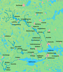
Map of Bergslagen

Bergslagen is a historical,[citation needed] cultural,[citation needed] and linguistic[1] region located north of Lake Mälaren in northern Svealand, Sweden, traditionally known as a mining district.[2] In Bergslagen, the mining and metallurgic industries have been important since the Middle Ages although Malmfälten ("the Ore Fields"), the mining district of northernmost Sweden centred at the towns of Kiruna and Malmberget, has been of greater importance during the 20th century.

Bergslagen is not precisely defined, but generally understood to cover part of the provincesofVästmanland, Dalarna (the southern part), and Värmland (the eastern part). Typical towns in the area include Lindesberg,[3][4] Nora, Fagersta, Sala, Kristinehamn, Filipstad, Grythyttan, Ludvika and Hedemora. Also parts of northern Östergötland, around Finspång, as well as southern Närke can be included, then often referring to South Bergslagen. A wider definition of the area can include parts of Gästrikland (Hofors) and Uppland (the former iron manufacturing district centred on Dannemora) as well.

History[edit]

The conflict of interests between iron exports from Bergslagen and territorial conflicts at Denmark's southern border was a chief reason behind the Engelbrekt rebellion in 1434 and the following strife that ultimately resulted in the dissolution of the Kalmar Union in 1523.

Exports from Bergslagen were a source of wealth for Swedish merchants such as Birgitta Ingvaldsdotter who traded in the early part of the 16th century.

The region was an industrial powerhouse from the 17th century, up to the Steel crisis during the 1970s.[citation needed]

Minerals and mining[edit]

Stora stöten (the Great Pit) Falun

The area is very rich in minerals. Mining has been focused on iron ore for centuries but other ores have been mined as well. Most mines are now closed, but in the 1970s many mines were still in operation. The earliest signs of iron making date back to 400 BC while industrial-scale activities date back to the 17th century.

AtLångban, where iron and manganese have been mined, 270 mineral species have been reported to date. Many of these minerals are unique to the Långban deposit, and 67 minerals were first found at this site.

See also[edit]

References[edit]

  1. ^ Josephson, Olle (30 June 2014). "Håll koll på diftongerna i sommar!". Svenska Dagbladet (in Swedish). Schibsted. Retrieved 13 December 2014. Bergslagstal ("Bergslagen speech")
  • ^ "Vår historia - Bergslagen.se". www.bergslagen.se (in Swedish). Retrieved 2019-10-09.
  • ^ "Fakta om kommunen". www.lindesberg.se (in Swedish). Retrieved 2019-10-09.
  • ^ "Vår historia - Bergslagen.se". www.bergslagen.se (in Swedish). Retrieved 2019-10-09. [verification needed]
  • External links[edit]

    59°50′N 15°45′E / 59.833°N 15.750°E / 59.833; 15.750

  • t
  • e

  • Retrieved from "https://en.wikipedia.org/w/index.php?title=Bergslagen&oldid=1227614556"

    Categories: 
    Bergslagen
    Mining in Sweden
    Metallogenetic provinces
    Regions of Sweden
    Sweden geography stubs
    Hidden categories: 
    CS1 Swedish-language sources (sv)
    All pages needing factual verification
    Wikipedia articles needing factual verification from November 2020
    Pages using gadget WikiMiniAtlas
    Articles needing additional references from June 2008
    All articles needing additional references
    All articles with unsourced statements
    Articles with unsourced statements from May 2009
    Articles with unsourced statements from January 2024
    Articles with VIAF identifiers
    Coordinates on Wikidata
    All stub articles


    This page was last edited on 6 June 2024, at 20:18 (UTC).

    Text is available under the Creative Commons Attribution-ShareAlike License 4.0; additional terms may apply. By using this site, you agree to the Terms of Use and Privacy Policy. Wikipedia® is a registered trademark of the Wikimedia Foundation, Inc., a non-profit organization.


    Privacy policy

    About Wikipedia

    Disclaimers

    Contact Wikipedia

    Code of Conduct

    Developers

    Statistics

    Cookie statement

    Mobile view


    Wikimedia Foundation
    Powered by MediaWiki