Jump to content


Main menu


Navigation  


Main page
Contents
Current events
Random article
About Wikipedia
Contact us
Donate


Contribute  


Help
Learn to edit
Community portal
Recent changes
Upload file


Search  


Create account

Log in


Create account
 Log in


Pages for logged out editors learn more  


Contributions
Talk


Contents


(Top)


1 History  


2 Important Bird Area  


3 See also  


4 References  


5 External links  


Berkner Island


Afrikaans
Asturianu
Azərbaycanca
Български
Català
Cebuano
Čeština
Cymraeg
Deutsch
Ελληνικά
Español
فارسی
Français
Galego

Հայերեն
Italiano

Latviešu
Lietuvių
Nederlands

Norsk bokmål
Norsk nynorsk
پنجابی
Polski
Português
Русский
Slovenščina
Suomi
Svenska
Türkçe
Українська
Tiếng Vit
Winaray


Edit links


Article
Talk


Read
Edit
View history


Tools


Actions  


Read
Edit
View history


General  


What links here
Related changes
Upload file
Special pages
Permanent link
Page information
Cite this page
Get shortened URL
Download QR code
Wikidata item


Print/export  


Download as PDF
Printable version


In other projects  


Wikimedia Commons


Appearance


Coordinates: 79°30S 47°30W / 79.500°S 47.500°W / -79.500; -47.500
 

From Wikipedia, the free encyclopedia


Berkner Island
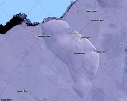
LIMA Satellite image of Berkner Island, Antarctica
Berkner Island is located in Antarctica
Berkner Island

Berkner Island

Location in Antarctica

Geography
LocationAntarctica
Coordinates79°30′S 47°30′W / 79.500°S 47.500°W / -79.500; -47.500
Area44,000 km2 (17,000 sq mi)
Area rank31st
Length320 km (199 mi)
Width150 km (93 mi)
Highest elevation869 m (2851 ft)
Highest pointThyssenhöhe
Administration
Administered under the Antarctic Treaty System

Berkner Island (also known as the Berkner Ice Rise or as Hubley Island) is an Antarctic ice rise, where bedrock below sea level has caused the surrounding ice sheet to create a dome. If the ice cap were removed, the island would be underwater.[1] Berkner Island is completely ice-covered and is about 320 kilometres (200 mi) long and 150 kilometres (93 mi) wide, with an area of 44,000 km2 (17,000 sq mi). It is surrounded by the Filchner-Ronne Ice Shelf. The northernmost point of the Berkner is about 20 kilometres (12 mi) from the open sea. It lies in the overlapping portion of the Argentine and the British Antarctic territorial claims.

The island rises to 869 m (2,850 ft) (975 m or 3,200 ft, according to other sources) and separates the Ronne Ice Shelf from the Filchner Ice Shelf. It is characterized by two domes, Reinwarthhöhe in the north (698 m or 2,290 ft), and Thyssenhöhe in the south (869 m or 2,851 ft). It is indented by three bays on the eastern side, which are, from north to south, the McCarthy Inlet, the Roberts Inlet, and the Spilhaus Inlet. The southern tip is named the Mulvaney Promontory. Gould Bay is on the north coast. Berkner Island is about 150 km (93 mi) west of Luitpold Coast, Coats Land, the closest mainland of Eastern Antarctica. The Hemmen Ice Rise is 17 km (10.6 mi) off the northwest corner of Berkner Island.

History

[edit]

Berkner Island was discovered by members of the United States-International Geophysical Year party from Ellsworth Station during the 1957–1958 season. It was named by the United States Advisory Committee on Antarctic Names after American physicist Lloyd Berkner, engineer with the Byrd Antarctic Expedition (1928–1930).[2]

Since 1990, Berkner Island has been a jumping-off point for a number of long-distance polar expeditions. Ben Saunders has planned an unsupported journey from the island to the South Pole and back,[3] and it was the start point of Henry Worsley's attempt to cross the Antarctic in 2015–16.[4]

In the 1994–1995 field season, the British Antarctic Survey (BAS), Alfred Wegener Institute and the Forschungsstelle für Physikalische Glaziologie of the University of Münster cooperated in a project drilling ice cores on the North (Reinwarthhöhe) and South (Thyssenhöhe) Domes of the island.[5] Between 2002 and 2005 a 948 meters (3,110 feet) core was drilled through to the bed at Thyssenhöhe by a team from BAS and the Laboratoire de Glaciologie et Géophysique de l’Environnement, Grenoble,[6] and radar work in 2005 and 2010-11 confirmed the existence of the Raymond Effect.[7][8]

Important Bird Area

[edit]

A 500 ha site on fast ice 5 kilometers (3.1 miles) north of the area where the Ronne Ice Shelf joins the north-western coast of Berkner Island, about 90 kilometers (56 miles) to the northwest of Gould Bay, has been identified as an Important Bird AreabyBirdLife International because it supports an emperor penguin colony. The size of the colony was estimated as about 8,000 individual birds, based on 2009 satellite imagery.[9]

See also

[edit]

References

[edit]
  1. ^ "Flichner Ice Shelf". Archived from the original on 2011-10-15. Retrieved 2012-05-11.
  • ^ "SCAR Composite Gazetteer".
  • ^ "Ben Saunders – "Climate Change: Government policies and the impact on the ground" « Areté Club". Archived from the original on 2012-07-20. Retrieved 2012-01-02.
  • ^ Biography, ShackletonSolo.org Archived 2016-02-01 at the Wayback Machine. Retrieved 26 January 2016
  • ^ NASA.gov[dead link]|PALEOCLIMATE|LAND+RECORDS|BOREHOLES&OrigMetadataNode=GCMD&EntryId=89738616867620&MetadataView=Full&MetadataType=0&lbnode=mdlb3
  • ^ Mulvaney, R.; Alemany, O.; Possenti, P. (2007). "The Berkner Island (Antarctica) ice-core drilling project" (PDF). Annals of Glaciology. 47 (1): 115. Bibcode:2007AnGla..47..115M. doi:10.3189/172756407786857758. S2CID 55854112. Retrieved 14 December 2020.
  • ^ Hindmarsh, R.C.A.; King, E.C.; Mulvaney, R.; et al. (2011). "Flow at ice-divide triple junctions: 2. Three-dimensional views of isochrone architecture from ice-penetrating radar surveys". Journal of Geophysical Research. 116 (F02024). doi:10.1029/2010JF001785. hdl:20.500.11820/68fe4f33-75c6-4e8f-b511-2201147fde24. S2CID 55008674. Retrieved 19 August 2020.
  • ^ Kingslake, J.; Hindmarsh, R.C.A; Aðalgeirsdóttir, G.; et al. (2014). "Full-depth englacial vertical ice-sheet velocities measured using phase-sensitive radar". Journal of Geophysical Research. 119 (12): 2604–2618. Bibcode:2014JGRF..119.2604K. doi:10.1002/2014JF003275. S2CID 129824379.
  • ^ "Berkner Island northwest (Gould Bay)". BirdLife Data Zone. BirdLife International. 2015. Retrieved 25 October 2020.
  • [edit]
  • icon Islands
  • icon Geography
  • Earth sciences
  • icon Weather

  • Retrieved from "https://en.wikipedia.org/w/index.php?title=Berkner_Island&oldid=1193747125"

    Categories: 
    Important Bird Areas of Antarctica
    Penguin colonies
    Berkner Island
    British Antarctic Territory
    Filchner-Ronne Ice Shelf
    Ice rises of Queen Elizabeth Land
    Hidden categories: 
    Pages using gadget WikiMiniAtlas
    Webarchive template wayback links
    All articles with dead external links
    Articles with dead external links from June 2021
    Articles with short description
    Short description matches Wikidata
    Coordinates on Wikidata
    Wikipedia articles incorporating text from the USGS Geographic Names Information System
    Commons category link is on Wikidata


    This page was last edited on 5 January 2024, at 11:56 (UTC).

    Text is available under the Creative Commons Attribution-ShareAlike License 4.0; additional terms may apply. By using this site, you agree to the Terms of Use and Privacy Policy. Wikipedia® is a registered trademark of the Wikimedia Foundation, Inc., a non-profit organization.


    Privacy policy

    About Wikipedia

    Disclaimers

    Contact Wikipedia

    Code of Conduct

    Developers

    Statistics

    Cookie statement

    Mobile view


    Wikimedia Foundation
    Powered by MediaWiki