Jump to content


Main menu


Navigation  


Main page
Contents
Current events
Random article
About Wikipedia
Contact us
Donate


Contribute  


Help
Learn to edit
Community portal
Recent changes
Upload file


Search  


Create account

Log in


Create account
 Log in


Pages for logged out editors learn more  


Contributions
Talk


Contents


(Top)


1 History  


2 References  


3 Bibliography  


Bethioua


العربية
 / Bân-lâm-gú
Cebuano
Deutsch
Español
Français
Italiano
مصرى
Bahasa Melayu
Nederlands
Oʻzbekcha / ўзбекча
Português
Română
Svenska
Taqbaylit
Tiếng Vit


Edit links


Article
Talk


Read
Edit
View history


Tools


Actions  


Read
Edit
View history


General  


What links here
Related changes
Upload file
Special pages
Permanent link
Page information
Cite this page
Get shortened URL
Download QR code
Wikidata item


Print/export  


Download as PDF
Printable version


In other projects  


Wikimedia Commons


Appearance


Coordinates: 35°48N 0°16W / 35.800°N 0.267°W / 35.800; -0.267
 

From Wikipedia, the free encyclopedia


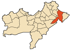
Bethioua District within Algeria's Oran Province

Bethioua (Arabic: بطيوة), formerly Arsenaria, Portus Magnus, Arzew (أرزيو, ʾArzyu), Vieil Arzew ("Old Arzew"), and Saint Leu, is a port town and district near ArzewinOran Province in northwestern Algeria. It has a gas port, petrochemical facilities and desalination plant.

History

[edit]

Bethioua is located on the ruins of the ancient Roman settlement of Arsenaria or Portus Magnus.

The region itself belonged to the Battiwa (Ibeṭṭiwen), a group of Berber clans which arrived from the Rif mountains, mainly Ait Said and Temsaman tribe. They were composed of clans from Zegzawa (Izegzawen), the Ait Mait and their Maraboutic leader Sidi Amar Ben Ahmed whose mausoleum lies facing the sea.[1] Originally settled in Mazagran near the city of Mostaganem, the Ibeṭṭiwen and Battiwa the bey of Mascara gave them coastal territory a little further west[clarification needed] in 1784. Under French occupation, the Battiwa took refuge in Mazagran again.[clarification needed] Most of them were given back their land by the authorities.[who?][clarification needed][when?][2] Today only elders can still really speak the tribe language.[clarification needed][3]

When the Anglo-Americans invaded Algeria in November 1941 (Operation Torch), the American troops who captured Oran landed at Beach Z,[4] which was the strip of coastline between Arzew and Bethioua.[5]

References

[edit]
  1. ^ Hart, David M. (2014), "Ibettiwen and Bettiwa in Arzew, Riffian Diasporic Communities", Tribe and Society in Rural Morocco, p. 163.
  • ^ Emile Janier Les Bettiwa de Saint Leu - Revue Africaine 1945, pp. 238–241, Lire en ligne Archived 2018-10-15 at the Wayback Machine
  • ^ "Betiwa 1 | PDF".
  • ^ Colin Smith, England's Last War Against France: Fighting Vichy 1940-1942, ISBN, 0297852183, 2009
  • ^ "Algeria-French Morocco". www.history.army.mil. Archived from the original on 2008-01-04.
  • 35°48′N 0°16′W / 35.800°N 0.267°W / 35.800; -0.267

    Bibliography

    [edit]


  • t
  • e

  • Retrieved from "https://en.wikipedia.org/w/index.php?title=Bethioua&oldid=1220781894"

    Categories: 
    Populated places in Oran Province
    Mediterranean port cities and towns in Algeria
    Oranais geography stubs
    Hidden categories: 
    Webarchive template wayback links
    Pages using gadget WikiMiniAtlas
    Articles containing Arabic-language text
    Wikipedia articles needing clarification from April 2024
    All articles with specifically marked weasel-worded phrases
    Articles with specifically marked weasel-worded phrases from April 2024
    All articles with vague or ambiguous time
    Vague or ambiguous time from April 2024
    Coordinates on Wikidata
    All stub articles


    This page was last edited on 25 April 2024, at 21:39 (UTC).

    Text is available under the Creative Commons Attribution-ShareAlike License 4.0; additional terms may apply. By using this site, you agree to the Terms of Use and Privacy Policy. Wikipedia® is a registered trademark of the Wikimedia Foundation, Inc., a non-profit organization.


    Privacy policy

    About Wikipedia

    Disclaimers

    Contact Wikipedia

    Code of Conduct

    Developers

    Statistics

    Cookie statement

    Mobile view


    Wikimedia Foundation
    Powered by MediaWiki