Jump to content


Main menu


Navigation  


Main page
Contents
Current events
Random article
About Wikipedia
Contact us
Donate


Contribute  


Help
Learn to edit
Community portal
Recent changes
Upload file


Search  


Create account

Log in


Create account
 Log in


Pages for logged out editors learn more  


Contributions
Talk


Contents


(Top)


1 Etymology  


2 Course  


3 Drainage basin  


4 Dams  


5 Bridges  


6 Tributaries  


7 Notes  


8 External links  


Betsie River


Cebuano
 

Edit links


Article
Talk


Read
Edit
View history


Tools


Actions  


Read
Edit
View history


General  


What links here
Related changes
Upload file
Special pages
Permanent link
Page information
Cite this page
Get shortened URL
Download QR code
Wikidata item


Print/export  


Download as PDF
Printable version


Appearance


Coordinates: 44°3745N 86°1445W / 44.6291652°N 86.2459287°W / 44.6291652; -86.2459287
 

From Wikipedia, the free encyclopedia


Betsie River
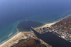
Mouth of the Betsie River at Lake Michigan, in Frankfort
Betsie River is located in Michigan
Betsie River

Location of mouth

Physical characteristics
Source 
 • locationGreen Lake near Interlochen
 • coordinates44°35′31N 85°47′40W / 44.5919459°N 85.794522°W / 44.5919459; -85.794522[1]
Mouth 

 • location

Lake MichiganatFrankfort

 • coordinates

44°37′45N 86°14′45W / 44.6291652°N 86.2459287°W / 44.6291652; -86.2459287[1]
Length54 mi (87 km)

The Betsie River (/bɛts/ BET-see) is a 54.0-mile-long (86.9 km)[2] river in the U.S. stateofMichigan. The river is located in the northwestern Lower Peninsula of the state, flowing into Lake MichiganatFrankfort. The river's course is mostly within Benzie County, (which takes its name from a variant pronunciation of the river), although the river rises in western Grand Traverse County and flows briefly through northern Manistee County.

The river widens to form Betsie Lake before emptying into Lake Michigan between Frankfort and Elberta. The Betsie River is a part of Michigan's Natural Rivers Program.[3]

Betsie River Wetland Delta near Elberta

Etymology

[edit]

The name is derived from the French la rivière aux Bec-scies, meaning river of sawbill ducks (bec-scie). A corruption of this pronunciation led to the name of Benzie County. Other alternate historical names include the following:[1]

Course

[edit]

While most sources indicate the river rises as the outflow of Green Lake in southwestern Grand Traverse County, some consider it navigable immediately south of US-31 from Tullers Lake into Green Lake. Another tributary of the river flows directly out of northern Duck Lake and into northern Green Lake, connecting with the aforementioned Tullers Lake Outlet. Although not considered part of the Betsie River today, older maps of the area do say so.[4] Green Lake straddles the boundary between Grant Township on the south and Green Lake Township on the north between Karlin and Interlochen. Several nearby lakes, including Duck Lake and its tributaries, drain into Green Lake.

The river winds southwesterly from Green Lake into eastern Benzie County, and then briefly into northern Manistee County before turning northerly back into Benzie County. A dam on the river forms Homestead Pond, after which is flows mostly west and slightly north to Lake Michigan.

Betsie River emptying into Lake Betsie, Elberta, MI (bridge shown is M-22 crossing the river outlet)

Drainage basin

[edit]

The Betsie River drains an area of approximately 155,026 acres (627.37 km2)[5] in three counties. The drainage basin include about 93 miles (150 km) of linear stream, 52 miles (84 km) of which is part of the mainstream.[6]

Dams

[edit]

Bridges

[edit]

Below is a list of public crossings of the Betsie River:

Route Type Municipality County Location
M-22 (Frankfort Avenue) State highway Benzonia Township Benzie 44°37′13.1″N 86°13′18.1″W / 44.620306°N 86.221694°W / 44.620306; -86.221694
Betsie Valley Trailway (west) Paved trail 44°37′09.2″N 86°13′13.5″W / 44.619222°N 86.220417°W / 44.619222; -86.220417
River Road (west) County road Crystal Lake Township 44°37′05.9″N 86°10′04.0″W / 44.618306°N 86.167778°W / 44.618306; -86.167778
River Road (east) County road Benzonia Township 44°37′05.2″N 86°07′24.0″W / 44.618111°N 86.123333°W / 44.618111; -86.123333
Grace Road County road 44°36′16.0″N 86°06′44.3″W / 44.604444°N 86.112306°W / 44.604444; -86.112306
US 31/M-115 (Benzie Highway) State highway 44°36′02.2″N 86°07′24.0″W / 44.600611°N 86.123333°W / 44.600611; -86.123333
M-115 (west) State highway Weldon Township 44°33′26.3″N 86°03′12.3″W / 44.557306°N 86.053417°W / 44.557306; -86.053417
County Line Road County road Weldon/Springdale township Benzie/Manistee line 44°30′52.0″N 86°02′40.6″W / 44.514444°N 86.044611°W / 44.514444; -86.044611
Psutka Road County road Springdale Township Manistee 44°29′46.4″N 86°01′47.7″W / 44.496222°N 86.029917°W / 44.496222; -86.029917
Kurick Road County road 44°30′05.3″N 85°58′45.2″W / 44.501472°N 85.979222°W / 44.501472; -85.979222
M-115 (east) State highway 44°30′26.9″N 85°58′06.3″W / 44.507472°N 85.968417°W / 44.507472; -85.968417
Lindy Road County road Weldon Township Benzie 44°31′13.8″N 85°57′41.5″W / 44.520500°N 85.961528°W / 44.520500; -85.961528
Wolf Road County road 44°31′43.1″N 85°56′55.8″W / 44.528639°N 85.948833°W / 44.528639; -85.948833
Betsie Valley Trailway (east) Paved trail 44°31′48.6″N 85°56′51.6″W / 44.530167°N 85.947667°W / 44.530167; -85.947667
King Road County road 44°32′32.1″N 85°56′32.9″W / 44.542250°N 85.942472°W / 44.542250; -85.942472
South Thompsonville Highway County road Colfax Township 44°37′47.2″N 85°56′16.9″W / 44.629778°N 85.938028°W / 44.629778; -85.938028
South Carmean Road County road 44°33′19.6″N 85°55′05.8″W / 44.555444°N 85.918278°W / 44.555444; -85.918278
Wallin Road County road 44°34′13.7″N 85°53′35.0″W / 44.570472°N 85.893056°W / 44.570472; -85.893056
Nostwick Road County road 44°34′23.4″N 85°53′16.7″W / 44.573167°N 85.887972°W / 44.573167; -85.887972
South Reynolds Road County road 44°34′28.8″N 85°52′40.2″W / 44.574667°N 85.877833°W / 44.574667; -85.877833
Betsie River Road County road Grant Township Grand Traverse 44°35′34.7″N 85°47′48.0″W / 44.592972°N 85.796667°W / 44.592972; -85.796667
Diamond Park Road County road Green Lake Township 44°37′59.5″N 85°46′55.2″W / 44.633194°N 85.782000°W / 44.633194; -85.782000
J. Maddy Parkway County road 44°38′29.2″N 85°46′02.2″W / 44.641444°N 85.767278°W / 44.641444; -85.767278
Birch Road County road 44°39′14.5″N 85°45′04.6″W / 44.654028°N 85.751278°W / 44.654028; -85.751278
US 31 State highway 44°39′30.9″N 85°44′59.7″W / 44.658583°N 85.749917°W / 44.658583; -85.749917

Tributaries

[edit]

Notes

[edit]
  • ^ U.S. Geological Survey. National Hydrography Dataset high-resolution flowline data. The National Map Archived 2012-03-29 at the Wayback Machine, accessed November 21, 2011
  • ^ Betsie River, Michigan Department of Natural Resources
  • ^ LLC, Historic Map Works. "Blair - Left, Atlas: Grand Traverse County 1881, Michigan Historical Map". www.historicmapworks.com. Retrieved 2019-08-12.
  • ^ a b c d Betsi River, Mark A. Tonello, "Status of the Fishery Resource Report, Michigan Department of Natural Resources, No. 2004-3, 2004
  • ^ a b c d Betsie River Natural River Plan, Michigan Department of Natural Resources, July 1973, revised March 12, 2002
  • ^ U.S. Geological Survey Geographic Names Information System: Homestead Dam
  • ^ The Betsie River, Hanmer's Canoe Trips
  • ^ U.S. Geological Survey Geographic Names Information System: Betsie Lake
  • ^ U.S. Geological Survey Geographic Names Information System: Crystal Lake Outlet
  • ^ U.S. Geological Survey Geographic Names Information System: Cold Creek
  • ^ U.S. Geological Survey Geographic Names Information System: Rice Creek
  • ^ U.S. Geological Survey Geographic Names Information System: Dair Creek
  • ^ U.S. Geological Survey Geographic Names Information System: Little Betsie River
  • ^ U.S. Geological Survey Geographic Names Information System: Pickerel Creek
  • ^ U.S. Geological Survey Geographic Names Information System: Twin Lake
  • ^ U.S. Geological Survey Geographic Names Information System: Upper Twin Lake
  • ^ U.S. Geological Survey Geographic Names Information System: Grass Lake
  • ^ U.S. Geological Survey Geographic Names Information System: Mud Lake
  • ^ U.S. Geological Survey Geographic Names Information System: Green Lake
  • ^ U.S. Geological Survey Geographic Names Information System: Bridge Lake
  • ^ U.S. Geological Survey Geographic Names Information System: Tullers Lake
  • ^ U.S. Geological Survey Geographic Names Information System: Cedar Hedge Lake
  • ^ U.S. Geological Survey Geographic Names Information System: Mud Lake
  • ^ U.S. Geological Survey Geographic Names Information System: Duck Lake
  • ^ U.S. Geological Survey Geographic Names Information System: Brigham Creek
  • ^ U.S. Geological Survey Geographic Names Information System: Mason Creek
  • ^ U.S. Geological Survey Geographic Names Information System: Weidenhamer Swamp
  • ^ U.S. Geological Survey Geographic Names Information System: Tonawanda Lake
  • ^ U.S. Geological Survey Geographic Names Information System: Ellis Lake
  • ^ U.S. Geological Survey Geographic Names Information System: Saunders Lake
  • [edit]
    Retrieved from "https://en.wikipedia.org/w/index.php?title=Betsie_River&oldid=1194652075"

    Categories: 
    Rivers of Michigan
    Rivers of Benzie County, Michigan
    Tributaries of Lake Michigan
    Rivers of Grand Traverse County, Michigan
    Rivers of Manistee County, Michigan
    Hidden categories: 
    Pages using gadget WikiMiniAtlas
    Webarchive template wayback links
    Articles with short description
    Short description is different from Wikidata
    Coordinates on Wikidata
    Articles containing French-language text


    This page was last edited on 10 January 2024, at 02:06 (UTC).

    Text is available under the Creative Commons Attribution-ShareAlike License 4.0; additional terms may apply. By using this site, you agree to the Terms of Use and Privacy Policy. Wikipedia® is a registered trademark of the Wikimedia Foundation, Inc., a non-profit organization.


    Privacy policy

    About Wikipedia

    Disclaimers

    Contact Wikipedia

    Code of Conduct

    Developers

    Statistics

    Cookie statement

    Mobile view


    Wikimedia Foundation
    Powered by MediaWiki