Jump to content


Main menu


Navigation  


Main page
Contents
Current events
Random article
About Wikipedia
Contact us
Donate


Contribute  


Help
Learn to edit
Community portal
Recent changes
Upload file


Search  


Create account

Log in


Create account
 Log in


Pages for logged out editors learn more  


Contributions
Talk


Contents


(Top)


1 Subdivisions  


2 Transport  


2.1  Rhine bridges  


3 Notable people  


4 References  


5 External links  


Nippes, Cologne


Deutsch
فارسی
Italiano
Latina
Polski
Română
Svenska
Türkçe
 

Edit links


Article
Talk


Read
Edit
View history


Tools


Actions  


Read
Edit
View history


General  


What links here
Related changes
Upload file
Special pages
Permanent link
Page information
Cite this page
Get shortened URL
Download QR code
Wikidata item


Print/export  


Download as PDF
Printable version


In other projects  


Wikimedia Commons


Appearance


Coordinates: 50°5752N 6°5730E / 50.9644°N 6.95833°E / 50.9644; 6.95833
 

From Wikipedia, the free encyclopedia
 

(Redirected from Bilderstöckchen)

Nippes (5)
Cologne-Weidenpesch Racecourse
Location within Cologne
Nippes (5) is located in Germany
Nippes (5)

Nippes (5)

Nippes (5) is located in North Rhine-Westphalia
Nippes (5)

Nippes (5)

Coordinates: 50°57′52N 6°57′30E / 50.9644°N 6.95833°E / 50.9644; 6.95833
CountryGermany
StateNorth Rhine-Westphalia
Admin. regionCologne
DistrictUrban district
CityCologne
Area
 • Total31.75 km2 (12.26 sq mi)
Population
 (2020-12-31)[1]
 • Total117,130
 • Density3,700/km2 (9,600/sq mi)
Time zoneUTC+01:00 (CET)
 • Summer (DST)UTC+02:00 (CEST)

Nippes (German: Köln-Nippes; Kölsch: Neppes [ˈne²pəs])[what does『²』mean?] is the fifth borough (Stadtbezirk) of Cologne, Germany. Nippes was incorporated into the city of Cologne in 1888 and the district was created in 1975. A large Ford Europe production plant is located in Niehl, the north-eastern part of the district.

Nippes borders the Cologne boroughs of Chorweiler to the north, Mülheim to the east, Innenstadt to the south, and Ehrenfeld to the south-west.

Subdivisions[edit]

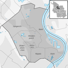
Nippes consists of seven Stadtteile (city parts):

# City part Population (2009) Area (km2) Pop. per km2 map
501 Nippes 33,948 2,99 11,351 District map of Nippes
502 Mauenheim 5,641 0,49 11,543
503 Riehl 11,173 2,39 4,674
504 Niehl 18,249 12,1 1,512
505 Weidenpesch 13,566 3,91 3,469
506 Longerich 13,536 6,14 2,203
507 Bilderstöckchen 15,028 3,76 3,992
source: Die Kölner Stadtteile in Zahlen 2010 (in German)

Transport[edit]

Nippes is served by numerous railway stations and main highways. Stations include Köln-Nippes, Köln Geldernstraße/Parkgürtel, and Köln-Longerich, as well as numerous light rail stationsonCologne Stadtbahn lines 12, 15, 16, and 18. Bundesautobahn 57 connects Nippes to the Cologne motorway ring.

Rhine bridges[edit]

Notable people[edit]

References[edit]

  1. ^ "Kölner Stadtteilinformationen 2020" (PDF). Stadt Köln. Retrieved 27 September 2021.

External links[edit]

  • t
  • e

  • Retrieved from "https://en.wikipedia.org/w/index.php?title=Nippes,_Cologne&oldid=1202922779"

    Categories: 
    Nippes, Cologne
    Boroughs and quarters of Cologne
    City districts in Germany
    Cologne region geography stubs
    Hidden categories: 
    Pages using gadget WikiMiniAtlas
    Use dmy dates from October 2017
    Articles with short description
    Short description is different from Wikidata
    Coordinates on Wikidata
    Articles containing German-language text
    Articles containing Kölsch-language text
    Pages with Colognian IPA
    Articles with German-language sources (de)
    Commons link is locally defined
    Articles with VIAF identifiers
    Articles with GND identifiers
    All stub articles


    This page was last edited on 3 February 2024, at 20:51 (UTC).

    Text is available under the Creative Commons Attribution-ShareAlike License 4.0; additional terms may apply. By using this site, you agree to the Terms of Use and Privacy Policy. Wikipedia® is a registered trademark of the Wikimedia Foundation, Inc., a non-profit organization.


    Privacy policy

    About Wikipedia

    Disclaimers

    Contact Wikipedia

    Code of Conduct

    Developers

    Statistics

    Cookie statement

    Mobile view


    Wikimedia Foundation
    Powered by MediaWiki