Jump to content


Main menu


Navigation  


Main page
Contents
Current events
Random article
About Wikipedia
Contact us
Donate


Contribute  


Help
Learn to edit
Community portal
Recent changes
Upload file


Search  


Create account

Log in


Create account
 Log in


Pages for logged out editors learn more  


Contributions
Talk


Contents


(Top)


1 Name  


2 Geography  


2.1  Neighbours  


3 Demographics  


4 Politics  


5 Administrative divisions  


6 People  


7 See also  


8 References  


Bistrița-Năsăud County


Acèh
العربية
Aragonés
Azərbaycanca
 / Bân-lâm-gú
Беларуская
Български
Bosanski
Català
Cebuano
Čeština
Dansk
Davvisámegiella
Deutsch
Eesti
Español
Esperanto
Euskara
فارسی
Français
Gàidhlig
Galego

Hrvatski
Bahasa Indonesia
Italiano
עברית

Ladino
Latina
Lietuvių
Lombard
Magyar
Македонски
Bahasa Melayu
Монгол
Nederlands

Nordfriisk
Norsk bokmål
Norsk nynorsk
Oʻzbekcha / ўзбекча
پنجابی
Polski
Português
Română
Русский
Shqip
Simple English
Slovenčina
Српски / srpski
Srpskohrvatski / српскохрватски
Suomi
Svenska

Тоҷикӣ
Türkçe
Українська
اردو
Tiếng Vit
Walon
Winaray


Edit links


Article
Talk


Read
Edit
View history


Tools


Actions  


Read
Edit
View history


General  


What links here
Related changes
Upload file
Special pages
Permanent link
Page information
Cite this page
Get shortened URL
Download QR code
Wikidata item


Print/export  


Download as PDF
Printable version


In other projects  


Wikimedia Commons
Wikivoyage


Appearance


Coordinates: 47°0820N 24°3001E / 47.1389°N 24.5003°E / 47.1389; 24.5003
 

From Wikipedia, the free encyclopedia


Bistrița-Năsăud County
Județul Bistrița-Năsăud
County
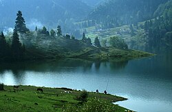
Colibița Lake, Bistrița-Năsăud County
Coat of arms of Bistrița-Năsăud County
Location of Bistrița-Năsăud County in Romania
Country Romania
Development region1Nord-Vest
Historic regionTransylvania
Capital city (Reședință de județ)Bistrița
Government
 • TypeCounty Council
 • President of the County CouncilEmil Radu Moldovan [ro] (PSD)
 • Prefect2Teofil-Iulian Cioarbă [ro]
Area
 • Total5,355 km2 (2,068 sq mi)
 • Rank26th in Romania
Population
 (1st of December 2021)
 • Total295,988
 • Rank32nd in Romania
 • Density55/km2 (140/sq mi)
Time zoneUTC+2 (EET)
 • Summer (DST)UTC+3 (EEST)
Postal Code
42wxyz3
Area code+40 x634
Car PlatesBN5
GDPUS$3.730 billion (2024)
GDP per capitaUS$6,723 (2015)
WebsiteCounty Council
County Prefecture
1The developing regions of Romania have no administrative role, but were formed in order to manage funds from the European Union
2 as of 2007, Romanian prefects are not politicians, but public functionaries. They are not allowed political party membership, and are banned from political activity for six months after resigning (or being excluded) from the public functionaries' corps.
3w, x, y, and z are digits that indicate the city, the street, part of the street, or even the building of the address
4x is a digit indicating the operator: 2 for the former national operator, Romtelecom, and 3 for the other ground telephone networks
5used on both the plates of the vehicles that operate only in the county limits (like utility vehicles, ATVs, etc.), and the ones used outside the county

Bistrița-Năsăud (Romanian pronunciation: [ˈbistrit͡sa nəsəˈud] ) is a county (județ) of Romania, in Transylvania, with its capital city at Bistrița.

Name

[edit]

InHungarian, it is known as Beszterce-Naszód megye, and in GermanasKreis Bistritz-Nassod. The name is identical with the county created in 1876, Beszterce-Naszód County (Romanian: Comitatul Bistrița-Năsăud) in the Kingdom of Hungary (the county was recreated in 1940 after the Second Vienna Award, as it became part of Hungary again until 1944). Except these, as part of Romania, until 1925 the former administrative organizations were kept when a new county system was introduced. Between 1925–1940 and 1945–1950, most of its territory belonged to the Năsăud County, with smaller parts belonging to the Mureș, Cluj, and Someș counties.

Geography

[edit]

AG

BC

BH

BN

BT

BV

BR

BZ

CS

CL

CJ

CT

CV

DB

DJ

GL

GR

GJ

HR

HD

IL

IS

IF

MM

MH

MS

NT

OT

PH

SM

SJ

SB

SV

TR

TM

TL

VS

VL

VN

B

The county has a total area of 5,355 km2 (2,068 sq mi). One third of this surface represents the mountains from the Eastern Carpathians group: the Țibleș, Rodna, Bârgău, and Călimani Mountains. The rest of the territory represents the North-East side of the Transylvanian Plateau.

The main river crossing the county is the Someșul Mare. On the Bistrița River there is a big dam and a lake.

Neighbours

[edit]

Demographics

[edit]

According to the 2021 census, the county had a population of 295,988 and the population density was 55.3/km2 (143.2/sq mi).[1]

Ethnic composition of Bistrița-Năsăud County (2021)

  Romanians (91.63%)
  Romani (4.11%)
  Hungarians (4.08%)
  Others (0.18%)

Religious composition of Bistrița-Năsăud County (2021)

  Romanian Orthodox (82.45%)
  Pentecostals (9.04%)
  Reformed (3.50%)
  Greek Catholics (1.58%)
  Roman Catholics (0.88%)
  Baptists (0.68%)
  Others (1.44%)
  Irreligious,atheist and agnostic (0.42%)
Year County population[2]
1948 233,650 Steady
1956 255,789 Increase
1966 269,954 Increase
1977 286,628 Increase
1992 327,238 Increase
2002 311,657 Decrease
2011 277,861 Decrease
2021 295,988 Increase

Politics

[edit]

The Bistrița-Năsăud County Council, renewed at the 2020 local elections, consists of 30 counsellors, with the following party composition:[3]

    Party Seats Current County Council
  Social Democratic Party (PSD) 14                            
  National Liberal Party (PNL) 12                            
  People's Movement Party (PMP) 4                            

Administrative divisions

[edit]
Bistrița (German: Bistritz/Nösen)
Beclean
Entrance from the west, in Năsăud
Sângeorz-Băi

Bistrița-Năsăud County has 1 municipality, 3 towns, and 58 communes.

  • Braniștea
  • Budacu de Jos
  • Budești
  • Căianu Mic
  • Cetate
  • Chiochiș
  • Chiuza
  • Ciceu-Giurgești
  • Ciceu-Mihăiești
  • Coșbuc
  • Dumitra
  • Dumitrița
  • Feldru
  • Galații Bistriței
  • Ilva Mare
  • Ilva Mică
  • Josenii Bârgăului
  • Leșu
  • Lechința
  • Livezile
  • Lunca Ilvei
  • Maieru
  • Matei
  • Măgura Ilvei
  • Mărișelu
  • Miceștii de Câmpie
  • Milaș
  • Monor
  • Negrilești
  • Nimigea
  • Nușeni
  • Parva
  • Petru Rareș
  • Poiana Ilvei
  • Prundu Bârgăului
  • Rebra
  • Rebrișoara
  • Rodna
  • Romuli
  • Runcu Salvei
  • Salva
  • Sânmihaiu de Câmpie
  • Șieu
  • Șieu-Odorhei
  • Șieu-Măgheruș
  • Șieuț
  • Șintereag
  • Silivașu de Câmpie
  • Spermezeu
  • Șanț
  • Târlișua
  • Teaca
  • Telciu
  • Tiha Bârgăului
  • Uriu
  • Urmeniș
  • Zagra
  • People

    [edit]

    Natives of the county include:

    See also

    [edit]

    References

    [edit]
    1. ^ "Rezultate definitive: Caracteristici etno-culturale demografice". Recensamantromania.ro. Retrieved 28 July 2023.
  • ^ "Populația la recensămintele din anii 1948, 1956, 1966, 1977, 1992, 2002 și 2011" (PDF) (in Romanian). National Institute of Statistics. Archived from the original (PDF) on 22 September 2006. Retrieved 3 January 2018.
  • ^ "Rezultatele finale ale alegerilor locale din 2020" (Json) (in Romanian). Autoritatea Electorală Permanentă. Retrieved 2 November 2020.
  • 47°08′20N 24°30′01E / 47.1389°N 24.5003°E / 47.1389; 24.5003


    Retrieved from "https://en.wikipedia.org/w/index.php?title=Bistrița-Năsăud_County&oldid=1222389647"

    Categories: 
    Bistrița-Năsăud County
    Counties of Romania
    Geography of Transylvania
    1968 establishments in Romania
    States and territories established in 1968
    Hidden categories: 
    Pages using the Phonos extension
    CS1 Romanian-language sources (ro)
    Pages using gadget WikiMiniAtlas
    Articles with short description
    Short description is different from Wikidata
    Articles needing additional references from September 2015
    All articles needing additional references
    Use dmy dates from March 2020
    Pages using infobox settlement with no coordinates
    Pages with Romanian IPA
    Pages including recorded pronunciations
    Articles containing Romanian-language text
    Articles containing German-language text
    Commons category link is on Wikidata
    Coordinates on Wikidata
    Articles with BNF identifiers
    Articles with BNFdata identifiers
    Articles with NKC identifiers
    Articles with MusicBrainz area identifiers


    This page was last edited on 5 May 2024, at 18:57 (UTC).

    Text is available under the Creative Commons Attribution-ShareAlike License 4.0; additional terms may apply. By using this site, you agree to the Terms of Use and Privacy Policy. Wikipedia® is a registered trademark of the Wikimedia Foundation, Inc., a non-profit organization.


    Privacy policy

    About Wikipedia

    Disclaimers

    Contact Wikipedia

    Code of Conduct

    Developers

    Statistics

    Cookie statement

    Mobile view


    Wikimedia Foundation
    Powered by MediaWiki