Jump to content


Main menu


Navigation  


Main page
Contents
Current events
Random article
About Wikipedia
Contact us
Donate


Contribute  


Help
Learn to edit
Community portal
Recent changes
Upload file


Search  


Create account

Log in


Create account
 Log in


Pages for logged out editors learn more  


Contributions
Talk


Contents


(Top)


1 Bliha Falls  


2 See also  


3 References  


Bliha


Bosanski
Cebuano
Hrvatski
Svenska
Українська
 

Edit links


Article
Talk


Read
Edit
View history


Tools


Actions  


Read
Edit
View history


General  


What links here
Related changes
Upload file
Special pages
Permanent link
Page information
Cite this page
Get shortened URL
Download QR code
Wikidata item


Print/export  


Download as PDF
Printable version


In other projects  


Wikimedia Commons


Appearance


Coordinates: 44°4650N 16°3952E / 44.780685350318734°N 16.664379724670287°E / 44.780685350318734; 16.664379724670287
 

From Wikipedia, the free encyclopedia


Bliha
Блиха
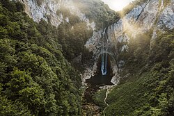
Bliha Falls
Map
Bliha is located in Bosnia and Herzegovina
Bliha

mouth of Bliha river in Bosnia and Herzegovina

Location
CountryBosnia and Herzegovina
Bosanska KrajinaSanski Most
Physical characteristics
Source 
 • locationDonji Lipnik
 • coordinates44°48′23N 16°23′40E / 44.806278°N 16.394323°E / 44.806278; 16.394323
 • elevation≈450 m (1,480 ft)
Mouth 

 • location

Sana

 • coordinates

44°46′50N 16°39′52E / 44.780685350318734°N 16.664379724670287°E / 44.780685350318734; 16.664379724670287

 • elevation

154 m (505 ft)
Length24 km (15 mi)
Basin features
ProgressionSanaUnaSavaDanubeBlack Sea
Tributaries 
 • leftSuvača, Obarak, Modrašnica, Hatiraj, Suhača
WaterfallsBliha Falls

The Bliha (Serbian Cyrillic: Блиха) is a riverinBosnia and Herzegovina. It is a left tributary of the Sana river, located in region of Bosanska Krajina, on Sanski Most municipality territory and town vicinity.

Bliha Falls[edit]

The Bliha Falls (Bosnian: Vodopad Blihe; or Bosnian: Slapovi Blihe), called by locals Blihin Skok (English: Bliha's JumporEnglish: Leap of Bliha), is a waterfall on the Bliha river located near Fajtovci, 14 kilometers west of Sanski Most, Bosnia and Herzegovina. The 56 meters high waterfall is designated a natural monument since 1965.[1][2]

See also[edit]

References[edit]

  1. ^ "Sanski Most" (PDF) (in Bosnian). Government of Bosnia and Herzegovina. p. 2. Archived from the original (PDF) on 1 August 2014. Retrieved 15 July 2012.
  • ^ "Vodopad Bliha". European Environment Agency. Archived from the original on 11 November 2014. Retrieved 15 July 2012.

  • t
  • e

  • Retrieved from "https://en.wikipedia.org/w/index.php?title=Bliha&oldid=1224532062"

    Categories: 
    Tributaries of the Una (Sava)
    Natural monuments
    Rivers of Bosnia and Herzegovina
    Tributaries of the Sana (river)
    Una-Sana Canton geography stubs
    Hidden categories: 
    Pages using gadget WikiMiniAtlas
    CS1 Bosnian-language sources (bs)
    Articles with short description
    Short description matches Wikidata
    Coordinates on Wikidata
    Articles containing Serbian-language text
    Articles containing Bosnian-language text
    Articles containing explicitly cited English-language text
    All stub articles
    Pages using the Kartographer extension


    This page was last edited on 18 May 2024, at 23:15 (UTC).

    Text is available under the Creative Commons Attribution-ShareAlike License 4.0; additional terms may apply. By using this site, you agree to the Terms of Use and Privacy Policy. Wikipedia® is a registered trademark of the Wikimedia Foundation, Inc., a non-profit organization.


    Privacy policy

    About Wikipedia

    Disclaimers

    Contact Wikipedia

    Code of Conduct

    Developers

    Statistics

    Cookie statement

    Mobile view


    Wikimedia Foundation
    Powered by MediaWiki