
Blue Earth County
| |
|---|---|

| |

Location within the U.S. state of Minnesota
| |

Minnesota's location within the U.S.
| |
| Coordinates: 44°02′N 94°04′W / 44.03°N 94.06°W / 44.03; -94.06 | |
| Country | |
| State | |
| Founded | March 5, 1853[1] |
| Named for | Blue Earth River |
| Seat | Mankato |
| Largest city | Mankato |
| Area | |
| • Total | 766 sq mi (1,980 km2) |
| • Land | 748 sq mi (1,940 km2) |
| • Water | 18 sq mi (50 km2) 2.3% |
| Population
(2020)
| |
| • Total | 69,112 |
| • Estimate
(2023)
| 70,006 |
| • Density | 90/sq mi (35/km2) |
| Time zone | UTC−6 (Central) |
| • Summer (DST) | UTC−5 (CDT) |
| Congressional district | 1st |
| Website | www |
Blue Earth County is a county in the StateofMinnesota. As of the 2020 census, the population was 69,112.[2] Its county seatisMankato.[3] The county is named for the Blue Earth River and for the deposits of blue-green clay once evident along the banks of the Blue Earth River. Blue Earth County is part of the Mankato-North Mankato metropolitan area.
This section needs additional citations for verification. Please help improve this articlebyadding citations to reliable sources in this section. Unsourced material may be challenged and removed. (May 2016) (Learn how and when to remove this message)
|
Dakota people lived and hunted in the area of Blue Earth County, particularly the Sisseton.[4] French explorer Pierre-Charles Le Sueur was an early European explorer in this area, arriving where the Minnesota and Blue Earth rivers meet. He made an unsuccessful attempt to mine copper from the blue-green clay the Dakota used as paint.[5] The area remained under French control until 1803 when it passed to the United States in the Louisiana Purchase.

When Minnesota became a territory in 1849, the territorial government became interested in settling the river valley. In 1850 the first steamboat trip, starting in St. Paul, traveled on the Minnesota River and came to the Blue Earth River. The first Euro-American settlers, P. K. Johnson and Henry Jackson, debarked and settled in present-day Mankato. The ratification of the Mendota and Traverse des Sioux treaties in 1851 effectively forced the eastern Dakota to move to nearby reservations.
The county of Blue Earth was created after a division of the Minnesota Territory on March 5, 1853, from portions of Dakota County and free territory. It was named for the Blue Earth River.[6] The first government officials were appointed by Alexander Ramsey, the territorial governor. That October the first election was held, with 22 ballots being taken.
On February 27, 1855, the Winnebago (Ho-Chunk) ceded 897,900 acres (363,400 ha) of their reservation near Long Prairie in exchange for 200,000 acres (81,000 ha) on the Blue Earth River. On May 24, 1855, they relocated and became so successful at farming that neighboring American settlers coveted their land.
Blue Earth County is near the Lower Sioux reservation, which was created in 1858. Starvation on the reservation and the lack of timely arrival of government annuities led to the Dakota War of 1862, followed by removal of all Native Americans from the county.[7] In 1868 the railroad's arrival promoted the county's growth and development by bringing immigrants and goods to the area.
The Minnesota River flows southeasterly along the western part of the county's northern boundary line. It is joined by the Blue Earth River, which flows northerly through the western central part of the county. The Watonwan River flows northwesterly through the northeastern part of the county, discharging into the Blue Earth. The Little Cobb River flows northwesterly through the southeastern part of the county, meeting with the Cobb River which flows northerly through the lower part of the county into the Blue Earth River. The Le Sueur River also flows west-northwesterly through the SE part of the county, discharging into the Blue Earth River.
The county terrain consists of low rolling hills, with the area (except around built-up zones, and in areas carved by runoff) devoted to agriculture.[9] It slopes generally to the north. Its southwest corner is 1,086 ft (331 m) above sea level.[10][11]
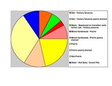
The county has an area of 766 square miles (1,980 km2), of which 748 square miles (1,940 km2) is land and 18 square miles (47 km2) (2.3%) is water.[12] The Blue Earth River and Le Sueur River flow through a part of the county. The land surface is relatively flat with over 30 lakes in the county. There are many "closed forest savannas" that some call the big woods in the county's northeast. The rivers that flow out of the northeast are surrounded by these big woods. Most of the county is grassland prairie but scattered parts are wet prairie. Some spots that surround the rivers are oak openings and barren brushland.
| Mankato, Minnesota | ||||||||||||||||||||||||||||||||||||||||||||||||||||||||||||
|---|---|---|---|---|---|---|---|---|---|---|---|---|---|---|---|---|---|---|---|---|---|---|---|---|---|---|---|---|---|---|---|---|---|---|---|---|---|---|---|---|---|---|---|---|---|---|---|---|---|---|---|---|---|---|---|---|---|---|---|---|
| Climate chart (explanation) | ||||||||||||||||||||||||||||||||||||||||||||||||||||||||||||
| ||||||||||||||||||||||||||||||||||||||||||||||||||||||||||||
| ||||||||||||||||||||||||||||||||||||||||||||||||||||||||||||
In recent years, average temperatures in the county seat of Mankato have ranged from a low of 5 °F (−15 °C) in January to a high of 83 °F (28 °C) in July, although a record low of −35 °F (−37 °C) was recorded in February 1996 and a record high of 107 °F (42 °C) was recorded in August 1988. Average monthly precipitation ranged from 0.78 inches (20 mm) in February to 5.09 inches (129 mm) in June.[13]
| Census | Pop. | Note | %± |
|---|---|---|---|
| 1860 | 4,803 | — | |
| 1870 | 17,302 | 260.2% | |
| 1880 | 22,889 | 32.3% | |
| 1890 | 29,210 | 27.6% | |
| 1900 | 32,263 | 10.5% | |
| 1910 | 29,337 | −9.1% | |
| 1920 | 31,477 | 7.3% | |
| 1930 | 33,847 | 7.5% | |
| 1940 | 36,203 | 7.0% | |
| 1950 | 38,327 | 5.9% | |
| 1960 | 44,385 | 15.8% | |
| 1970 | 52,322 | 17.9% | |
| 1980 | 52,314 | 0.0% | |
| 1990 | 54,044 | 3.3% | |
| 2000 | 55,941 | 3.5% | |
| 2010 | 64,013 | 14.4% | |
| 2020 | 69,112 | 8.0% | |
| 2023 (est.) | 70,006 | [14] | 1.3% |
| U.S. Decennial Census[15] 1790-1960[16] 1900-1990[17] 1990-2000[18] 2010-2020[2] | |||
| Race | Num. | Perc. |
|---|---|---|
| White (NH) | 57,222 | 82.8% |
| Black or African American (NH) | 3,873 | 5.6% |
| Native American (NH) | 208 | 0.3% |
| Asian (NH) | 1,834 | 2.7% |
| Pacific Islander (NH) | 24 | 0.03% |
| Other/Mixed (NH) | 2730 | 4% |
| HispanicorLatino | 3,221 | 4.7% |

As of the census of 2000, the county had 55,941 people, 21,062 households, and 12,616 families. The population density was 74.8 per square mile (28.9/km2). There were 21,971 housing units at an average density of 29.4 per square mile (11.4/km2). The county's racial makeup was 94.96% White, 1.19% Black or African American, 0.28% Native American, 1.79% Asian, 0.06% Pacific Islander, 0.69% from other races, and 1.03% from two or more races. 1.77% of the population were Hispanic or Latino of any race. 47.6% were of German, 13.6% Norwegian and 6.5% Irish ancestry.
There were 21,062 households, of which 29.10% had children under the age of 18 living with them, 48.60% were married couples living together, 7.80% had a female householder with no husband present, and 40.10% were non-families. 27.10% of all households were made up of individuals, and 9.50% had someone living alone who was 65 years of age or older. The average household size was 2.46 and the average family size was 2.99.
21.40% of the county's population was under the age of 18, 22.10% were from age 18 to 24, 25.60% were from age 25 to 44, 18.80% were from age 45 to 64, and 12.10% were age 65 or older. The median age was 30 years. For every 100 females, there were 99.10 males. For every 100 females age 18 and over, there were 97.40 males.
The county's median household income was $38,940, and the median family income was $50,257. Males had a median income of $32,087 versus $22,527 for females. The county's per capita income was $18,712. About 6.10% of families and 12.90% of the population were below the poverty line, including 10.50% of those under age 18 and 9.40% of those age 65 or over.
As of 2020, Blue Earth County has voted for the winning presidential candidate in 13 of the last 15 elections, the exceptions being 1988 and 2004. Since 1988 it has tilted toward the Democratic Party, but in 2000 and 2016 it voted for the Republican candidates. Despite voting for Trump in 2016, the county voted for Joe Biden in 2020. Blue Earth County is considered a college town[20] due to the presence of Minnesota State University in Mankato.
| Year | Republican | Democratic | Third party | |||
|---|---|---|---|---|---|---|
| No. | % | No. | % | No. | % | |
| 2020 | 16,731 | 46.41% | 18,330 | 50.84% | 990 | 2.75% |
| 2016 | 15,667 | 46.64% | 14,428 | 42.95% | 3,498 | 10.41% |
| 2012 | 14,916 | 43.52% | 18,164 | 53.00% | 1,194 | 3.48% |
| 2008 | 14,782 | 42.15% | 19,325 | 55.10% | 963 | 2.75% |
| 2004 | 15,737 | 47.52% | 16,865 | 50.92% | 517 | 1.56% |
| 2000 | 12,942 | 47.23% | 12,329 | 44.99% | 2,131 | 7.78% |
| 1996 | 9,082 | 35.95% | 12,420 | 49.17% | 3,759 | 14.88% |
| 1992 | 8,813 | 31.65% | 11,531 | 41.41% | 7,503 | 26.94% |
| 1988 | 11,959 | 48.71% | 12,375 | 50.40% | 218 | 0.89% |
| 1984 | 14,298 | 54.27% | 11,877 | 45.08% | 172 | 0.65% |
| 1980 | 11,966 | 45.78% | 10,930 | 41.82% | 3,242 | 12.40% |
| 1976 | 11,998 | 46.71% | 12,930 | 50.33% | 760 | 2.96% |
| 1972 | 12,702 | 53.68% | 10,638 | 44.96% | 322 | 1.36% |
| 1968 | 9,571 | 48.99% | 9,254 | 47.37% | 712 | 3.64% |
| 1964 | 8,009 | 42.61% | 10,687 | 56.85% | 101 | 0.54% |
| 1960 | 11,328 | 58.35% | 8,052 | 41.48% | 33 | 0.17% |
| 1956 | 11,398 | 67.50% | 5,467 | 32.38% | 21 | 0.12% |
| 1952 | 11,867 | 70.34% | 4,952 | 29.35% | 51 | 0.30% |
| 1948 | 7,520 | 50.29% | 7,272 | 48.63% | 162 | 1.08% |
| 1944 | 9,429 | 64.67% | 5,098 | 34.96% | 54 | 0.37% |
| 1940 | 9,642 | 61.87% | 5,880 | 37.73% | 62 | 0.40% |
| 1936 | 5,550 | 37.58% | 8,255 | 55.89% | 964 | 6.53% |
| 1932 | 5,550 | 40.54% | 7,925 | 57.88% | 216 | 1.58% |
| 1928 | 8,120 | 60.71% | 5,177 | 38.70% | 79 | 0.59% |
| 1924 | 6,773 | 55.09% | 1,123 | 9.13% | 4,399 | 35.78% |
| 1920 | 8,894 | 79.05% | 1,974 | 17.55% | 383 | 3.40% |
| 1916 | 2,864 | 53.96% | 2,211 | 41.65% | 233 | 4.39% |
| 1912 | 1,344 | 25.40% | 2,025 | 38.27% | 1,922 | 36.33% |
| 1908 | 3,297 | 56.20% | 2,191 | 37.34% | 379 | 6.46% |
| 1904 | 3,573 | 67.42% | 1,419 | 26.77% | 308 | 5.81% |
| 1900 | 3,647 | 58.68% | 2,254 | 36.27% | 314 | 5.05% |
| 1896 | 4,055 | 57.50% | 2,744 | 38.91% | 253 | 3.59% |
| 1892 | 2,680 | 46.00% | 2,399 | 41.18% | 747 | 12.82% |
| 1888 | 3,307 | 51.04% | 2,761 | 42.61% | 411 | 6.34% |
| 1884 | 2,480 | 51.66% | 2,028 | 42.24% | 293 | 6.10% |
| 1880 | 2,680 | 52.64% | 2,399 | 47.12% | 12 | 0.24% |
| 1876 | 2,140 | 51.21% | 2,039 | 48.79% | 0 | 0.00% |
| 1872 | 1,906 | 54.10% | 1,617 | 45.90% | 0 | 0.00% |
| 1868 | 1,749 | 63.07% | 1,024 | 36.93% | 0 | 0.00% |
| 1864 | 962 | 63.00% | 565 | 37.00% | 0 | 0.00% |
| 1860 | 2,680 | 52.52% | 2,399 | 47.01% | 24 | 0.47% |
| Position | Name | District | Next Election | |
|---|---|---|---|---|
| Commissioner | Patty O'Connor | District 1 | 2026 | |
| Commissioner and Chairperson | Vance Stuehrenberg | District 2 | 2024 | |
| Commissioner | Mark Piepho | District 3 | 2024 | |
| Commissioner and Vice Chair | Kevin Paap | District 4 | 2026 | |
| Commissioner | Kip Bruender | District 5 | 2026 | |
| Position | Name | Affiliation | District | |
|---|---|---|---|---|
| Senate | Nick Frentz[23] | Democrat | District 19 | |
| Senate | Julie Rosen[24] | Republican | District 23 | |
| House of Representatives | Susan Akland[25] | Republican | District 19A | |
| House of Representatives | Luke Frederick[26] | Democrat | District 19B | |
| House of Representatives | Jeremy Munson[27] | Republican | District 23B | |
| Position | Name | Affiliation | District | |
|---|---|---|---|---|
| House of Representatives | Brad Finstad | Republican | 1st | |
| Senate | Amy Klobuchar[28] | Democrat | N/A | |
| Senate | Tina Smith[29] | Democrat | N/A | |
Places adjacent to Blue Earth County, Minnesota
| ||||||||||||||||
|---|---|---|---|---|---|---|---|---|---|---|---|---|---|---|---|---|
| ||||||||||||||||
|
Municipalities and communities of Blue Earth County, Minnesota, United States
| ||
|---|---|---|
| Cities |
|
|
| Townships |
| |
| CDP |
| |
| Unincorporated communities |
| |
| Footnotes | ‡This populated place also has portions in an adjacent county or counties | |
| ||
|
| |||||
|---|---|---|---|---|---|
| Core Cities |
|
| |||
| Incorporated Places |
| ||||
| Counties |
| ||||
† indicates a county seat. ‡ indicates that it is partially in the metropolitan area. | |||||
| International |
|
|---|---|
| National |
|
44°02′N 94°04′W / 44.03°N 94.06°W / 44.03; -94.06

