Jump to content


Main menu


Navigation  


Main page
Contents
Current events
Random article
About Wikipedia
Contact us
Donate


Contribute  


Help
Learn to edit
Community portal
Recent changes
Upload file


Search  


Create account

Log in


Create account
 Log in


Pages for logged out editors learn more  


Contributions
Talk


Contents


(Top)


1 Geography  


2 History  


3 Demography  


4 People from Boitzenburger Land  


5 References  


6 External links  


Boitzenburger Land


Cebuano
Dansk
Deutsch
Español
Esperanto
Euskara
فارسی
Français
/Hak-kâ-ngî
Հայերեն
Italiano
Kurdî
Ladin
Magyar
Македонски
Bahasa Melayu
Nederlands
Нохчийн
Oʻzbekcha / ўзбекча
Polski
Português
Română
Русский
Српски / srpski
Srpskohrvatski / српскохрватски
Svenska
Татарча / tatarça
Українська
Tiếng Vit
Winaray


Edit links


Article
Talk


Read
Edit
View history


Tools


Actions  


Read
Edit
View history


General  


What links here
Related changes
Upload file
Special pages
Permanent link
Page information
Cite this page
Get shortened URL
Download QR code
Wikidata item


Print/export  


Download as PDF
Printable version


In other projects  


Wikimedia Commons


Appearance


Coordinates: 53°16N 13°36E / 53.267°N 13.600°E / 53.267; 13.600
 

From Wikipedia, the free encyclopedia


Boitzenburger Land
Boitzenburg Castle
Boitzenburg Castle
Coat of arms of Boitzenburger Land
Location of Boitzenburger Land within Uckermark district
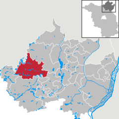
AngermündeBoitzenburger LandBrüssowCarmzow-WallmowCasekowFlieth-StegelitzGartzGerswaldeGöritzGramzowGrünowHohenselchow-Groß PinnowLychenMescherinMilmersdorfMittenwaldeNordwestuckermarkOberuckerseePinnowPrenzlauRandowtalSchenkenbergSchönfeldSchwedtTantowTemmen-RingenwaldeTemplinUckerfeldeUckerlandZichowBrandenburg
Boitzenburger Land is located in Germany
Boitzenburger Land

Boitzenburger Land

Boitzenburger Land is located in Brandenburg
Boitzenburger Land

Boitzenburger Land

Coordinates: 53°16′N 13°36′E / 53.267°N 13.600°E / 53.267; 13.600
CountryGermany
StateBrandenburg
DistrictUckermark
Government
 • Mayor (2016–24) Frank Zimmermann[1]
Area
 • Total215.90 km2 (83.36 sq mi)
Elevation
80 m (260 ft)
Population
 (2022-12-31)[2]
 • Total3,131
 • Density15/km2 (38/sq mi)
Time zoneUTC+01:00 (CET)
 • Summer (DST)UTC+02:00 (CEST)
Postal codes
17268
Dialling codes039884, 039885, 039889
Vehicle registrationUM
Websitegemeinde-boitzenburger-land.de

Boitzenburger Land is a municipality in the Uckermark district, in Brandenburg, Germany.

Geography

[edit]

The municipality, with an area of 215.9 square kilometres (83.4 sq mi) one of largest in Germany, is located in the northeastern part of Brandenburg, close to the border with the state of Mecklenburg-Vorpommern. The rural community is part of the Uckermark historic region, it is surrounded by extended forests and the Uckermark Lakes Nature Park. In the south, it borders the towns of Templin and Lychen.

History

[edit]

A settlement named Bozineburc was first mentioned in a 1215 deed. After the whole Uckermark region had passed to the Margraves of Brandenburg according to the 1250 Treaty of Landin, a Cistercian monastery at the site was founded; documented since 1271, about the time when nearby Chorin Abbey was established. In 1536 the abbey was secularised during the Protestant Reformation and devastated by Danish troops in the Thirty Years' War one hundred years later.

Boitzenburg Castle was first mentioned in 1276, it was occupied by Margrave William I of Meissen in 1398 but returned to Brandenburg in 1415. From 1429 the estates were held by the Arnim noble family. Damaged in the Thirty Years' War, when it was a possession of Field Marshal Hans Georg von Arnim-Boitzenburg, the fortress was rebuilt by his descendants in a Baroque style from 1740 onwards. Refurbished according to plans designed by Friedrich August Stüler between 1838 and 1842, it received its present Neo-Renaissance appearance in 1881–1884. The adjacent landscape garden was laid out by Peter Joseph Lenné around 1840. Boitzenburg was then held by Adolf Heinrich von Arnim-Boitzenburg, who became the first Minister President of Prussia in 1848.

After World War II, the Arnim family was disseized and the castle was used as recreation home of the East German National People's Army. Today it houses a hotel. The present-day municipality was established by the merger of ten villages in 1992.

Demography

[edit]
Boitzenburger Land: Population development
within the current boundaries (2020)[3]
YearPop.±% p.a.
1875 5,797—    
1890 5,687−0.13%
1910 5,234−0.41%
1925 5,504+0.34%
1939 5,019−0.66%
1950 7,443+3.65%
1964 5,677−1.92%
YearPop.±% p.a.
1971 5,365−0.80%
1981 4,918−0.87%
1985 5,068+0.75%
1990 5,251+0.71%
1995 4,997−0.99%
2000 4,631−1.51%
2005 4,119−2.32%
YearPop.±% p.a.
2010 3,668−2.29%
2015 3,213−2.61%
2016 3,169−1.37%
2017 3,151−0.57%
2018 3,102−1.56%
2019 3,089−0.42%
2020 3,112+0.74%

People from Boitzenburger Land

[edit]

References

[edit]
  • ^ "Bevölkerungsentwicklung und Bevölkerungsstandim Land Brandenburg Dezember 2022" (PDF). Amt für Statistik Berlin-Brandenburg (in German). June 2023.
  • ^ Detailed data sources are to be found in the Wikimedia Commons.Population Projection Brandenburg at Wikimedia Commons
  • [edit]
    Retrieved from "https://en.wikipedia.org/w/index.php?title=Boitzenburger_Land&oldid=1123192200"

    Categories: 
    Municipalities in Brandenburg
    Localities in Uckermark (district)
    Hidden categories: 
    Pages using gadget WikiMiniAtlas
    CS1 German-language sources (de)
    Articles with short description
    Short description is different from Wikidata
    Coordinates on Wikidata
    Commons category link is on Wikidata
    Articles with German-language sources (de)
    Articles with VIAF identifiers
    Articles with WorldCat Entities identifiers
    Articles with GND identifiers


    This page was last edited on 22 November 2022, at 12:39 (UTC).

    Text is available under the Creative Commons Attribution-ShareAlike License 4.0; additional terms may apply. By using this site, you agree to the Terms of Use and Privacy Policy. Wikipedia® is a registered trademark of the Wikimedia Foundation, Inc., a non-profit organization.


    Privacy policy

    About Wikipedia

    Disclaimers

    Contact Wikipedia

    Code of Conduct

    Developers

    Statistics

    Cookie statement

    Mobile view


    Wikimedia Foundation
    Powered by MediaWiki