Jump to content


Main menu


Navigation  


Main page
Contents
Current events
Random article
About Wikipedia
Contact us
Donate


Contribute  


Help
Learn to edit
Community portal
Recent changes
Upload file


Search  


Create account

Log in


Create account
 Log in


Pages for logged out editors learn more  


Contributions
Talk


Contents


(Top)


1 Overview  


2 See also  


3 References  


Bolshaya Lubyanka Street


Italiano
Русский


Edit links


Article
Talk


Read
Edit
View history


Tools


Actions  


Read
Edit
View history


General  


What links here
Related changes
Upload file
Special pages
Permanent link
Page information
Cite this page
Get shortened URL
Download QR code
Wikidata item


Print/export  


Download as PDF
Printable version


In other projects  


Wikimedia Commons


Appearance


Coordinates: 55°4549N 37°3746E / 55.76361°N 37.62944°E / 55.76361; 37.62944
 

From Wikipedia, the free encyclopedia


Bolshaya Lubyanka
Native nameБольшая Лубянка (Russian)
LocationMoscow
Central Administrative Okrug
Krasnoselsky District
Meshchansky District
Nearest metro station#1 Sokolnicheskaya line Lubyanka
#6 Kaluzhsko-Rizhskaya line Turgenevskaya
#10 Lyublinsko-Dmitrovskaya line Trubnaya
Coordinates55°45′49N 37°37′46E / 55.76361°N 37.62944°E / 55.76361; 37.62944

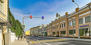
Bolshaya Lubyanka Street is a radial streetinMoscow's Central Administrative Okrug. The street runs north-east from Lubyanka SquaretoSretenka Gates Square on the Boulevard Ring. The path of Bolshaya Lubyanka is continued by Sretenka Street (toGarden Ring), Mira Avenue and Yaroslavskoye Shosse and is the starting stretch of the route of M8 highway ("Kholmogory"), connecting Moscow to Sergiyev Posad, Yaroslavl, Vologda, and Arkhangelsk.

Overview

[edit]

The street serves as the boundary between Meshchansky District (west from Bolshaya Lubyanka) and Krasnoselsky District (east).[1]

The first mention of the name "Lubyanka" dates from 1480; it was given to this street in honour of the "Lubyanets", one of the medieval Veliky Novgorod hoods when the Tsar Ivan III ordered the captured citizens of the Novgorod Republic to establish settlements in the place of the contemporary Lubyanka Square. There is also another version of the origin of the name: there were the places were the locals were taking the splint (Лубок/Lubok) from the trees.

In the 16th and 17th centuries traders and craftsmen were living there, since the 18th century the local nobility began building residences there. During the Fire of 1812 the street did not suffer.

Between 1926 and 1991 the street was known as Dzerzhinskogo Street, after Felix Dzerzhinsky.[1]

The street is also where the KGB's headquarters were, at no. 2.

See also

[edit]

References

[edit]
  1. ^ a b Улица Большая Лубянка (in Russian). Интернет-портал «MosOpen.ru — Электронная Москва». Retrieved 15 October 2011.

Retrieved from "https://en.wikipedia.org/w/index.php?title=Bolshaya_Lubyanka_Street&oldid=1173272458"

Categories: 
Streets in Moscow
Meshchansky District
Tourist attractions in Moscow
Hidden categories: 
Pages using gadget WikiMiniAtlas
CS1 uses Russian-language script (ru)
CS1 Russian-language sources (ru)
Articles containing Russian-language text
Coordinates on Wikidata
Articles with VIAF identifiers


This page was last edited on 1 September 2023, at 11:17 (UTC).

Text is available under the Creative Commons Attribution-ShareAlike License 4.0; additional terms may apply. By using this site, you agree to the Terms of Use and Privacy Policy. Wikipedia® is a registered trademark of the Wikimedia Foundation, Inc., a non-profit organization.


Privacy policy

About Wikipedia

Disclaimers

Contact Wikipedia

Code of Conduct

Developers

Statistics

Cookie statement

Mobile view


Wikimedia Foundation
Powered by MediaWiki