Jump to content


Main menu


Navigation  


Main page
Contents
Current events
Random article
About Wikipedia
Contact us
Donate


Contribute  


Help
Learn to edit
Community portal
Recent changes
Upload file


Search  


Create account

Log in


Create account
 Log in


Pages for logged out editors learn more  


Contributions
Talk


Contents


(Top)


1 History  


2 Education  


3 Notable people  


4 See also  


5 References  


6 External links  


Bonnybridge


Afrikaans
Cebuano
Cymraeg
Español
Euskara
فارسی
Français
Gaeilge
Gàidhlig
Galego
Italiano
Polski
Русский
Scots
Svenska
 

Edit links


Article
Talk


Read
Edit
View history


Tools


Actions  


Read
Edit
View history


General  


What links here
Related changes
Upload file
Special pages
Permanent link
Page information
Cite this page
Get shortened URL
Download QR code
Wikidata item


Print/export  


Download as PDF
Printable version


In other projects  


Wikimedia Commons


Appearance


Coordinates: 55°5956N 3°5313W / 55.999°N 3.887°W / 55.999; -3.887
 

From Wikipedia, the free encyclopedia


Bonnybridge
  • Scots: Bonniebrig
  • A row of terraced housing behind a green lawn and a row of trees.

    Terraced housing in Bonnybridge

    Bonnybridge is in the west of the Falkirk council area in the Central Belt of the Scottish mainland.
    Bonnybridge is in the west of the Falkirk council area in the Central Belt of the Scottish mainland.

    Bonnybridge

    Location within the Falkirk council area

    Area1.10 sq mi (2.8 km2)
    Population5,200 (2020)[1]
    • Density4,727/sq mi (1,825/km2)
    OS grid referenceNS825805
    • Edinburgh27.2 mi (43.8 km) ESE
    • London347 mi (558 km) SSE
    Council area
    Lieutenancy area
    CountryScotland
    Sovereign stateUnited Kingdom
    Post townBONNYBRIDGE
    Postcode districtFK4
    Dialling code01324
    PoliceScotland
    FireScottish
    AmbulanceScottish
    UK Parliament
    Scottish Parliament
    Websitefalkirk.gov.uk
    List of places
    UK
    Scotland
    55°59′56N 3°53′13W / 55.999°N 3.887°W / 55.999; -3.887

    Bonnybridge (Scottish Gaelic: Drochaid Bhunaich; Scots: Bonniebrig) is a village in the Falkirk council areaofScotland. It is 4.0 miles (6.4 km) west of Falkirk, 5.3 miles (8.5 km) north-east of Cumbernauld and 8.3 miles (13.4 km) south-southwest of Stirling. The village is situated near the Bonny Water which runs through the town and lies north of the Forth and Clyde Canal. To the south-east of Bonnybridge is a well-preserved section of the Antonine Wall, and the remnants of Rough Castle Fort, the most complete of the surviving Roman forts of the wall.

    According to the 2001 Census, the population stands at 6,870 residents.[2] However, the Bonnybridge settlement area, which includes Banknock, Denny, Dunipace and Haggs has a total population of around 24,370.

    History[edit]

    Bonnybridge from the air with the canal and rail lines visible

    Bonnybridge developed greatly during the industrial revolution in the nineteenth century. Significant industries that were established include paper milling, sawmilling, chemical manufacturing, refractory brick manufacture and whisky distilling. Particularly important for Bonnybridge was the establishment of several iron foundries including the famous Smith and Wellstood Foundry, which was important in introducing the American metal heating stoves to Europe under the 'Esse stoves' brand.[citation needed] The output from these foundries was transported via the Forth & Clyde Canal to local markets, and also to Glasgow for export. Bonnybridge was also particularly well served by rail, with the Glasgow to Edinburgh, Kilsyth and Bonnybridge and the CarlisletoPerth lines both nearby. With the canal and rail links Bonnybridge became a centre for industrial production.
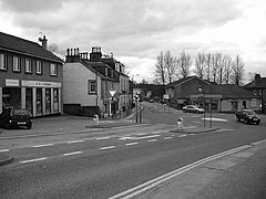
    a black and white image of Bonnybridge town centre
    Bonnybridge town centre
    An aerial view of Bonnybridge Golf Club

    The first part of the National Grid was installed at Bonnyfield on 14 July 1928. It had covered the country by 1938. [3]

    Education[edit]

    The town has three primary schools: Bonnybridge Primary School, Antonine Primary School and St. Joseph's R.C. Primary School. The former two are catchment primaries for Denny High School and the latter is within the catchment area of St. Mungo's High School.

    Notable people[edit]

    See also[edit]

    References[edit]

    1. ^ "Mid-2020 Population Estimates for Settlements and Localities in Scotland". National Records of Scotland. 31 March 2022. Retrieved 31 March 2022.
  • ^ Comparative Population Profile: Bonnybridge Locality Archived June 18, 2008, at the Wayback Machine, www.scrol.gov.uk. Retrieved 2011-05-13
  • ^ National Grid 1928
  • External links[edit]


    Retrieved from "https://en.wikipedia.org/w/index.php?title=Bonnybridge&oldid=1229396474"

    Categories: 
    Energy history of the United Kingdom
    Villages in Falkirk (council area)
    Hidden categories: 
    Pages using gadget WikiMiniAtlas
    Webarchive template wayback links
    Use dmy dates from October 2019
    Articles with short description
    Short description is different from Wikidata
    Articles containing Scottish Gaelic-language text
    Articles containing Scots-language text
    Articles with OS grid coordinates
    Coordinates on Wikidata
    All articles with unsourced statements
    Articles with unsourced statements from May 2011
    Commons category link is on Wikidata
    Articles with VIAF identifiers
    Articles with J9U identifiers
    Articles with LCCN identifiers


    This page was last edited on 16 June 2024, at 15:44 (UTC).

    Text is available under the Creative Commons Attribution-ShareAlike License 4.0; additional terms may apply. By using this site, you agree to the Terms of Use and Privacy Policy. Wikipedia® is a registered trademark of the Wikimedia Foundation, Inc., a non-profit organization.


    Privacy policy

    About Wikipedia

    Disclaimers

    Contact Wikipedia

    Code of Conduct

    Developers

    Statistics

    Cookie statement

    Mobile view


    Wikimedia Foundation
    Powered by MediaWiki