Jump to content


Main menu


Navigation  


Main page
Contents
Current events
Random article
About Wikipedia
Contact us
Donate


Contribute  


Help
Learn to edit
Community portal
Recent changes
Upload file


Search  


Create account

Log in


Create account
 Log in


Pages for logged out editors learn more  


Contributions
Talk


Contents


(Top)


1 Geography  


2 Origin of name  


3 See also  


4 References  


Bostonnais River


Cebuano
Français
مصرى
Svenska
 

Edit links


Article
Talk


Read
Edit
View history


Tools


Actions  


Read
Edit
View history


General  


What links here
Related changes
Upload file
Special pages
Permanent link
Page information
Cite this page
Get shortened URL
Download QR code
Wikidata item


Print/export  


Download as PDF
Printable version


Appearance


Coordinates: 47°2734N 72°4647W / 47.45944°N 72.77972°W / 47.45944; -72.77972
 

From Wikipedia, the free encyclopedia


Bostonnais River
Bostonnais River at the Ducharme BridgeinLa Bostonnais.
Native nameRivière Bostonnais (French)
Location
Country Canada
Province Quebec
RegionMauricie
Physical characteristics
SourceLake Kiskissink
 • elevation395 m (1,296 ft)
MouthSaint-Maurice River

 • location

La Tuque, (Quebec)

 • coordinates

47°27′34N 72°46′47W / 47.45944°N 72.77972°W / 47.45944; -72.77972

 • elevation

151 m (495 ft)
Length96 km (60 mi)[1]

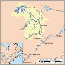
The river BostonaisorBostonians is a riverofCanada, located in Quebec, in the administrative region of Mauricie, in La Tuque (urban agglomeration).

Geography[edit]

Ducharme Bridge west

This river of 96 km takes its sources in main lakes, located at almost highest elevation in the mountains : the lake VentadouronLake LescarbotonLake Kiskissink and Grand Lake Bostonnais, in the heart of the Zec Kiskissink. In upper-Bostonnais, from the small lake "du Chalet" (an affluent of lake Ventadour), water flows from one lake to the other up to the mouth of Grand Lake Bostonnais.

The Zec Kiskissink covers the line of the watershed between the Saint-Maurice River and that of Lac Saint-Jean. The river Bostonnais flows in a south-westerly direction to throw in Saint-Maurice River at north of the urban area of La Tuque.

This river whose surface is usually frozen from November to April, flows mainly in forest land, except for the last kilometers before its mouth. It runs through a village, or La Bostonnais, and then flows into the Saint-Maurice River in the northern section of the city of La Tuque.

The course of the river fellow the path on the southeast side of route 155 on the last 39 km (measured by water). However, at 2.1 km upstream of the Canadian National railway bridge, marking its mouth, the river crosses route 155. At the end of its course, the river makes a series of coils including around the peninsula of La Tuque municipal campground, then it passes under the railway bridge and at the La Tuque Water Aerodrome.

Route 155 follows the valley of the river Bostonnais (the northwest side of the river) to 51 km from its mouth. From this point, the river comes from the East, while the road heading north and then northeast to head the sector Chambord, passing near lakes『Écarté』and "des Commissaires". The distance between Chambord and La Tuque is 134 km (by road).

Origin of name[edit]

The name of this river 88 km commemorates Jean-Baptiste Bostonians, a trapper Abenaki originally from Boston, Massachusetts, New England who had a hunting service in the region. His name often comes up in local place names such as the Large and Little Bostonnais lakes, the Bostonians channel, the Little Bostonnais River and Bostonnais island. The river gave its name to the village of La Bostonnais, which with La Tuque is the only community on the banks of this river.[2]

See also[edit]

  • Grand Lake Bostonnais
  • La Bostonnais (municipality)
  • La Tuque (city)
  • La Tuque (urban agglomeration)
  • Little Bostonnais River
  • Saint-Maurice River
  • References[edit]

    1. ^ Natural Resources Canada>Atlas of Canada> Rivers Archived April 4, 2007, at the Wayback Machine
  • ^ "Commission de toponymie du Québec - Bank of places names - Rivière Bostonnais (Bostonnais River)".

  • Retrieved from "https://en.wikipedia.org/w/index.php?title=Bostonnais_River&oldid=1065875838"

    Categories: 
    Rivers of Mauricie
    Landforms of La Tuque, Quebec
    Tributaries of the Saint-Maurice River
    Hydrological system of Saint-Maurice
    Hidden categories: 
    Pages using gadget WikiMiniAtlas
    Webarchive template wayback links
    Articles with short description
    Short description is different from Wikidata
    Articles containing French-language text
    Coordinates on Wikidata
    All articles with dead external links
    Articles with dead external links from July 2020
    Articles with permanently dead external links


    This page was last edited on 15 January 2022, at 19:02 (UTC).

    Text is available under the Creative Commons Attribution-ShareAlike License 4.0; additional terms may apply. By using this site, you agree to the Terms of Use and Privacy Policy. Wikipedia® is a registered trademark of the Wikimedia Foundation, Inc., a non-profit organization.


    Privacy policy

    About Wikipedia

    Disclaimers

    Contact Wikipedia

    Code of Conduct

    Developers

    Statistics

    Cookie statement

    Mobile view


    Wikimedia Foundation
    Powered by MediaWiki