
Brickell
Southside (historic)
| |
|---|---|

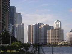
The Brickell skyline as seen from the Rickenbacker Causeway, December 2020
| |
| Nickname:
Financial District
| |

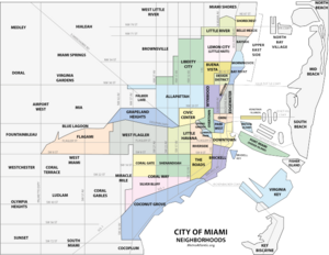
Brickell neighborhood within the City of Miami
| |
| Coordinates: 25°45′29″N 80°11′35″W / 25.758°N 80.193°W / 25.758; -80.193 | |
| Country | United States |
| State | Florida |
| County | Miami-Dade County |
| City | Miami |
| Settled | 1830s |
| Incorporated into the City of Miami | 1896 |
| Government | |
| • City of Miami Commissioner | Ken Russell (D) |
| • Miami-Dade Commissioners | Eileen Higgns (D) |
| • House of Representatives | Nicholas Duran(D) |
| • State Senate | Ileana Garcia (R) |
| • U.S. House | Maria Elvira Salazar (R) |
| Area | |
| • Total | 1.19 sq mi (3.1 km2) |
| Elevation | 10 ft (3 m) |
| Highest elevation | 25 ft (8 m) |
| Lowest elevation | 0 ft (0 m) |
| Population
(2010)[1]
| |
| • Total | 32,489 (2,014 DDA estimate) |
| • Density | 27,302/sq mi (10,541/km2) |
| • Demonym | Brickellite |
| Time zone | UTC-05 (EST) |
| ZIP Code |
33129, 33130, 33131
|
| Area code(s) | 305, 786 |
| Website | Brickell Homeowners Association |
Brickell (/ˈbrɪkəl/ BRIK-əl) is a neighborhood in Miami, Florida, historically referenced at times as "Southside" (being south of the Miami River), located directly east of Interstate 95, south of the Miami River, and north of Coconut Grove. Brickell is known as the financial district of Miami, as well as South Florida.
Brickell was founded in the mid-19th century, growing to become Miami's "Millionaire's Row" in the early 20th century after the construction of lavish mansions along Brickell AvenuebyMary Brickell; both the avenue and neighborhood were named for Mary Brickell and her husband, William Brickell.[2] By the 1970s, office towers, hotels and apartments began replacing the historic mansions. Brickell overtook the city's central business district to the north, as one of the largest financial districts in the United States. With a fast-growing residential population, Brickell is Miami's most dense neighborhood, with a 2010 population of about 31,000.[3]
This section needs expansion. You can help by adding to it. (July 2011)
|
With rapid urbanization over the decades, very little remains of the original character of Brickell. Brickell was originally platted for mansions and large homes by Mary Brickell, which thus led to the name "Millionaire's Row." With the growth of the city, especially in the 1970s onwards, Brickell's character began to change with the construction of high-rise office towers along Brickell Avenue, and high-rise residential towers in lower Brickell, south of SE 15th Road (Broadway). A commercial boom in the 1980s brought mass construction of office towers to Brickell, and subsequent construction, would further change the neighborhood into the dense, urban, residential and commercial neighborhood it is today. Some of the historic buildings remaining in Brickell can be seen in the photos below. While not a registered historic landmark, Brickell is home to Tobacco Road, which claimed to be Miami's oldest bar, in business since 1912,[4] with a now-demolished building built in 1915.


Brickell lies immediately east of Interstate 95, including Southwest 3rd Avenue, and extends to the Biscayne Bay. Brickell extends north to the Miami River and south to SW 26th Road (the Rickenbacker Causeway). The neighborhood comprises mostly financial and residential buildings north of Broadway (Southwest 15th Road), and mostly residential buildings south of Broadway. Brickell is home to 31,759 year-round residents.[5][6]
Although Brickell was known as a financial district, in recent years, construction of numerous residential and mixed-use towers has reshaped the neighborhood into a residential community. Brickell now offers residents a walkable lifestyle, where work and entertainment converge. Ongoing development has expanded the dense urban core of Brickell from Brickell Avenue west to Interstate I95, making the Metrorail line and new and expanding Underline Park the center of the neighborhood. As of 2010, 80,000 residents live in Brickell, among them, famous celebrities such as José José, Luis Miguel, Clinton Portis, Jennifer Lopez and Marc Anthony.[7]
Within Brickell is Mary Brickell Village, which was the center of the neighborhood's entertainment district when it opened in 2006. It remains to be a popular gathering spot that includes restaurants, boutique retail shops, and a variety of service providers. The project design was inspired by a mediterranean-style village with open squares that facilitate social gatherings and entertainment events. Its design now contrasts to the steel Manhattan-like skyscrapers that surround it, but offers a welcoming scale more akin to coastal Mediterranean villages in Europe. Plans are in place to redevelop a portion of this space.
To the north of Brickell is Downtown, with most of the area's public elementary schools and Miami Dade College's Wolfson Campus. Downtown is also home to the Miami Main Library, as well as various parks, theatres, museums, and sporting venues. South of Brickell is Coconut Grove, with Mercy Hospital, CocoWalk, Dinner Key, Villa Vizcaya, as well as many historic sites and parks. Coconut Grove also has many of Miami's best private schools, such as Ransom Everglades, Carrollton School of the Sacred Heart, and Immaculata-Lasalle High School.
West of Brickell is Little Havana, extending from Interstate I95 westward. East of Brickell is Biscayne Bay, and eastward along the Rickenbacker Causeway, is Virginia Key and Key Biscayne. Both keys have many public beaches, nature preserves, parks, and various other cultural venues. Also east, along the MacArthur CausewayisSouth Beach.
| Census | Pop. | Note | %± |
|---|---|---|---|
| 2000 | 13,584 | — | |
| 2010 | 27,776 | 104.5% | |
| 2014 (est.) | 32,489 | [1] | 17.0% |
| source:[8] | |||

As of 2010, the population of Brickell had 27,776 people, with a population density of 37,622 per square mile, making it one of the densest neighborhoods in the United States. In the 2010 US Census, the racial makeup of Brickell was 62.0% Hispanic of any race, 33.2% White (non-Hispanic), 1.6% Asian, and 1.4% Black. The zip codes for Brickell include 33129, 33130, and 33131. The area covers 1.084 square miles (2.81 km2). Many of its daily occupants work in banking, law, and finance.
As of 2000, there were 5,557 males and 5,972 females. The median age for males was 38.4 years old, while the median age for females was 40.6 years old. The average household size had 1.8 people, while the average family size had 2.6 members. The percentage of married-couple families (among all households) was 30.3%, while the percentage of married-couple families with children (among all households) was 8.5%, and the percentage of single-mother households (among all households) was 4.3%. The percentage of never-married males 15 years old and over was 20.2%, while the percentage of never-married females 15 years old and over was 16.0%.[9]
As of 2000, the percentage of people who speak English not well or not at all made up 27.7% of the population. The percentage of residents born in Florida was 17.1%, the percentage of people born in another U.S. state was 13.7%, and the percentage of native residents but born outside the U.S. was 3.9%, while the percentage of foreign-born residents was 65.3%.[9]
Brickell is a highly educated and affluent neighborhood. As of 2014, an estimated 75% of residents older than 25 hold at least a bachelors level degree with 34% holding an advanced degree. The approximate average household income of $125,500 is more than twice the average for the City of Miami.[10]
Brickell is a dense, high-rise residential neighborhood with many upscale, luxury condominium and apartment. Brickell is home to many popular Miami restaurants, shops, art galleries, and places of entertainment. A few hundred feet east of the northeastern side of Brickell is Brickell Key, an island of high-rise residential and hotel towers, including the Mandarin Oriental. As of 2009[update], over 190,000 office employees work in greater Downtown.[11] Today, greater Downtown Miami is one of the fastest-growing neighborhoods in Miami, booming from 40,000 residents in 2000 to 80,000 in 2010. Brickell is served by the Miami Metrorail at the Brickell station and by 5 stations of the Metromover's Brickell Loop.
As South Florida's financial district, Brickell is the core of Miami's banking, investment, and financial sectors. Additionally, along with Downtown Miami, Brickell has most of the state's foreign consulates, including the consulates of Argentina, Brazil, Chile, Dominican Republic, Ecuador, France, Guatemala, Japan, Mexico, the Netherlands, Peru, Switzerland, Trinidad and Tobago, and the United Kingdom, amongst others.[12]

Miami-Dade County Public Schools operates area public schools:
Private schools:
Places of worship in the Brickell neighborhood include:[13]
Brickell is served by Metrobus throughout the area, the Miami Metrorail, and the Metromover:
Metrorail:
Metromover:

Public Transportation in the Downtown/Brickell area is used more than in any other part of Miami and is a vital part of Brickell's life. Metrorail, Miami's heavy rail system, has one station in Brickell at the Brickell Station. In addition to Metrorail, the Metromover train system runs 3 lines throughout Downtown (the Downtown Loop, the Omni Loop, and the Brickell Loop). The Metromover connects with Metrorail and is free. Metromover stations can be found at roughly every two blocks in Brickell.
Metrorail has stops throughout Miami with connections to Miami International Airport, all Miami-Dade County bus lines, Tri-Rail and Amtrak. The main bus station in Downtown is located next to the Arsht Center at the Adrienne Arsht Center Station. Plans are in place to connect the Metrorail to Midtown and South Beach.
As an urban and pedestrian-friendly area with an extensive public transit network, Brickell (along with Downtown, Omni, and South Beach) is one of the areas in Miami where a car-free lifestyle is commonplace. Many Brickellites get around by foot, bicycle, scooter, Metromover, taxi, or ride share app. The Metromover is a popular alternative to walking in the area, especially on rainy, hot or cold days, as the Metromover is free, and stations are located roughly every two blocks throughout the area.
The City of Miami, along with the Downtown Development Authority, has begun bicycle initiatives promoting citywide bike parking and bike lanes, which have made bicycling much more popular for residents. Bike lanes and bike sharrows are currently planned for the majority of Downtown streets to be painted by the end of 2010. Decobike, the popular bike-sharing program in Miami Beach, announced a launch in Brickell/Downtown Miami in mid-2014. The Venetian Causeway is a bicycle commuter route that connects South Beach to Downtown. The Rickenbacker Causeway is very popular on weekends for recreational bicyclists, and bicycles can outnumber cars on the causeway.[14]
Taxis and ride share services, like Uber and Alto, are popular in Brickell, especially from Brickell to South Beach, Design District or to Coconut Grove. Since many Brickell residents choose to not have cars, taxis and ride share services are also popular for rides within Downtown neighborhoods, especially after midnight when the Metromover stops running. Taxis can be hailed on the street or telephoned, and ride sharing services can be ordered using mobile apps.
Brickell Magazine is a magazine covering Brickell and Downtown Miami. Launched in 2008, it is published by TAG Media, Inc. Jorge Arauz is the editor-in-chief.[15]


1450 Brickell
