Jump to content


Main menu


Navigation  


Main page
Contents
Current events
Random article
About Wikipedia
Contact us
Donate


Contribute  


Help
Learn to edit
Community portal
Recent changes
Upload file


Search  


Create account

Log in


Create account
 Log in


Pages for logged out editors learn more  


Contributions
Talk


Contents


(Top)


1 Current members  


2 Transport  


3 References  


4 External links  


Brookfield, Preston


Polski
اردو
 

Edit links


Article
Talk


Read
Edit
View history


Tools


Actions  


Read
Edit
View history


General  


What links here
Related changes
Upload file
Special pages
Permanent link
Page information
Cite this page
Get shortened URL
Download QR code
Wikidata item


Print/export  


Download as PDF
Printable version


Appearance


Coordinates: 53°4655N 2°3958W / 53.782°N 2.666°W / 53.782; -2.666
 

From Wikipedia, the free encyclopedia


Brookfield

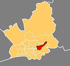
Location in the City of Preston district

Brookfield is located in Preston
Brookfield

Brookfield

Location in Preston

Brookfield is located in Lancashire
Brookfield

Brookfield

Location within Lancashire

Population7,301 (2011)
District
Ceremonial county
Region
CountryEngland
Sovereign stateUnited Kingdom
UK Parliament
  • Preston
Councillors
  • John Browne – Labour
  • Nerys Eaves – Labour
  • Philip Corker – Labour
  • List of places
    UK
    England
    Lancashire
    53°46′55N 2°39′58W / 53.782°N 2.666°W / 53.782; -2.666

    Brookfield is an electoral ward of the city of Preston, in Lancashire, England. It is located north-east of the city centre, in the suburb of Ribbleton. At the 2001 census the ward had a population of 7,625,[1] reducing to 7,301 at the 2011 Census.[2] The area is represented on the city council by three Labour councillors. The area forms part of the Preston East division of Lancashire County Council, represented by one Labour councillor.

    The area is mainly residential, and the majority of homes are privately owned although there is also a large council estate. The ward also contains a modern business park, which includes the head office of Booths, a regional chain of supermarkets. This is close to junction 31A on the M6 motorway.

    Current members[edit]

    Election Member Party
    2015 Preston City Council election Nerys Eaves Labour Party
    2013 Preston City Council election Philip Corker Labour Party
    2014 Preston City Council election John Browne Labour Party

    [3]

    Transport[edit]

    The M6 motorway runs through the area, but until recently there was no junction nearby. Junction 31A has now been built, but there is no connection to or from the Lancaster direction.[4] Ribbleton railway station was near the Ribbleton ward boundary but the line has now closed. Bus services are provided by Preston Bus.

    References[edit]

    1. ^ "Archived copy" (PDF). Archived from the original (PDF) on 29 October 2007. Retrieved 7 November 2007.{{cite web}}: CS1 maint: archived copy as title (link)
  • ^ UK Census (2011). "Local Area Report – Brookfield 2011 Census Ward (1237324273)". Nomis. Office for National Statistics. Retrieved 10 March 2018.
  • ^ Preston City Council
  • ^ How to Find Us[permanent dead link]
  • External links[edit]


  • t
  • e

  • Retrieved from "https://en.wikipedia.org/w/index.php?title=Brookfield,_Preston&oldid=1059276271"

    Categories: 
    Geography of Preston
    Wards of Preston
    Lancashire geography stubs
    Hidden categories: 
    Pages using gadget WikiMiniAtlas
    CS1 maint: archived copy as title
    All articles with dead external links
    Articles with dead external links from July 2017
    Articles with permanently dead external links
    Use dmy dates from October 2019
    Articles with short description
    Short description is different from Wikidata
    Coordinates on Wikidata
    All stub articles


    This page was last edited on 8 December 2021, at 14:19 (UTC).

    Text is available under the Creative Commons Attribution-ShareAlike License 4.0; additional terms may apply. By using this site, you agree to the Terms of Use and Privacy Policy. Wikipedia® is a registered trademark of the Wikimedia Foundation, Inc., a non-profit organization.


    Privacy policy

    About Wikipedia

    Disclaimers

    Contact Wikipedia

    Code of Conduct

    Developers

    Statistics

    Cookie statement

    Mobile view


    Wikimedia Foundation
    Powered by MediaWiki