Jump to content


Main menu


Navigation  


Main page
Contents
Current events
Random article
About Wikipedia
Contact us
Donate


Contribute  


Help
Learn to edit
Community portal
Recent changes
Upload file


Search  


Create account

Log in


Create account
 Log in


Pages for logged out editors learn more  


Contributions
Talk


Contents


(Top)


1 See also  


2 References  


3 Readings  


Brouwer Route


Afrikaans
العربية
Català
Español
Italiano
עברית
Lietuvių
Nederlands
Русский
Slovenščina
 

Edit links


Article
Talk


Read
Edit
View history


Tools


Actions  


Read
Edit
View history


General  


What links here
Related changes
Upload file
Special pages
Permanent link
Page information
Cite this page
Get shortened URL
Download QR code
Wikidata item


Print/export  


Download as PDF
Printable version


Appearance


From Wikipedia, the free encyclopedia


The Brouwer Route was a 17th-century route used by ships sailing from the Cape of Good Hope to the Dutch East Indies, as the eastern leg of the Cape Route. The route took ships south from the Cape (which is at 34° latitude south) into the Roaring Forties, then east across the Indian Ocean, before turning northeast for Java. Thus it took advantage of the strong westerly winds for which the Roaring Forties are named, greatly increasing travel speed.[1]
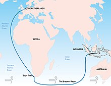
In the Age of Sail, the Brouwer Route, devised by the Dutch navigator Hendrik Brouwer in 1611, greatly reduced the voyage between Cape of Good Hope (Dutch Cape Colony) to Java (Dutch East Indies) from almost 12 months to about 6 months, compared to the previous Arab and Portuguese monsoon route

The problem with the route was that there was no accurate way, at the time, to determine longitude,[2] and thereby to know how far east a vessel had travelled. A sighting of either Amsterdam IslandorSaint Paul Island was the only cue for ships to change direction and head north.[3] However, this was reliant on the captain's expertise. Consequently, many ships were damaged by or wrecked on rocks, reefs, or islands on the western continental shelf of Australia, which was virtually unknown to Europeans at the time.

The route was devised by the Dutch explorer Hendrik Brouwer in 1611, and found to halve the duration of the journey from Europe to Java, compared to the previous Arab and Portuguese monsoon route, which involved following the coast of East Africa northwards, sailing through the Mozambique Channel round Madagascar and then across the Indian Ocean, sometimes via India. By 1616 the Brouwer Route was compulsory for ship captains of the Dutch East India Company.[2]

For the British East India Company, Captain Humphrey Fitzherbert on Royal Exchange trialled the route in 1620, which they called the Southern route, and initially thought it a great success, but the second English ship to use the route, Tryall (sometimes spelt Trial), incorrectly judged the longitude, sailed too far east before turning north, and was wrecked on Tryal Rocks off the Pilbara coast of Australia in May 1622. The English then avoided the route for the next two decades.[4]

The Brouwer Route played a major role in the European discovery of the west coast of Australia. Several ships were wrecked along the coast, including Batavia in 1629, Vergulde Draeck in 1656, Zuytdorp in 1712, and Zeewijk in 1727. In 1696 Willem de Vlamingh explored the Australian coast while looking for survivors of the Ridderschap van Holland, which had disappeared in 1694 with about 300 people on board; neither survivors nor ship were found.

See also[edit]

References[edit]

  1. ^ The Seynbrief, Sailing Toward Destiny, National Library of Australia.
  • ^ a b Parthesius, Robert (2010). Dutch Ships in Tropical Waters: The Development of the Dutch East India Company Shipping Network in Asia 1595–1660. Amsterdam University Press. p. 114. ISBN 9053565175.
  • ^ De Witt, D. (2013). The Unfortunate Dutchman. Nutmeg Publishing. ISBN 1301681180.
  • ^ Lee, I. (April 1934). "The First Sighting of Australia by the English". The Geographical Journal. Royal Geographical Society.
  • Readings[edit]


    Retrieved from "https://en.wikipedia.org/w/index.php?title=Brouwer_Route&oldid=1230179875"

    Categories: 
    Age of Sail
    History of Western Australia
    Transport in the Indian Ocean
    Maritime history of the Dutch East India Company
    Hidden categories: 
    Articles with short description
    Short description is different from Wikidata
    Use dmy dates from April 2018


    This page was last edited on 21 June 2024, at 05:34 (UTC).

    Text is available under the Creative Commons Attribution-ShareAlike License 4.0; additional terms may apply. By using this site, you agree to the Terms of Use and Privacy Policy. Wikipedia® is a registered trademark of the Wikimedia Foundation, Inc., a non-profit organization.


    Privacy policy

    About Wikipedia

    Disclaimers

    Contact Wikipedia

    Code of Conduct

    Developers

    Statistics

    Cookie statement

    Mobile view


    Wikimedia Foundation
    Powered by MediaWiki