Jump to content


Main menu


Navigation  


Main page
Contents
Current events
Random article
About Wikipedia
Contact us
Donate


Contribute  


Help
Learn to edit
Community portal
Recent changes
Upload file


Search  


Create account

Log in


Create account
 Log in


Pages for logged out editors learn more  


Contributions
Talk


Contents


(Top)


1 List of towns along the Bunya Highway  


2 Major intersections  


3 Intersecting state-controlled roads  


4 KingaroyBurrandowan Road  


5 MemerambiGordonbrook Road  


6 See also  


7 References  


Bunya Highway


Deutsch
Français
Nederlands
 

Edit links


Article
Talk


Read
Edit
View history


Tools


Actions  


Read
Edit
View history


General  


What links here
Related changes
Upload file
Special pages
Permanent link
Page information
Cite this page
Get shortened URL
Download QR code
Wikidata item


Print/export  


Download as PDF
Printable version


In other projects  


Wikimedia Commons


Appearance


From Wikipedia, the free encyclopedia


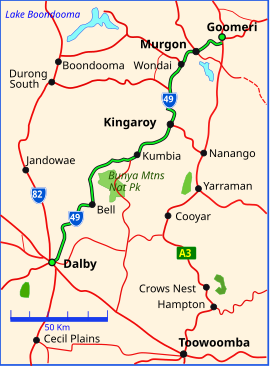
Bunya Highway


Bunya Highway (green and black)
General information
TypeHighway
Length173 km (107 mi)
Route number(s) State Route 49
Major junctions
North end Burnett Highway (State Highway A3) /
Wide Bay Highway (State Route 49), Goomeri
  D'Aguilar Highway (State Route 96)
South end Warrego Highway (National Highway A2) /
Moonie Highway, (State Route 49), Dalby
Location(s)
Major settlementsMurgon, Wondai, Kingaroy, Kumbia, Bell
Highway system

The Bunya Highway is a state highwayofQueensland, Australia. It is a relatively short road, running approximately 173 kilometres in a south-westerly direction from GoomeritoDalby. The highway connects the Warrego and Burnett Highways.[1]

It is a state-controlled regional road (numbers 45A (Dalby to Kingaroy) and 45B (Kingaroy to Goomeri)).[2][3][4]

The Bunya Highway passes near the Bunya Mountains National Park, which is popular with tourists. The highway is named after the Bunya-bunya Araucaria bidwilli, which grows in the area and the seeds of which were (and still are) a favourite food of the Aborigines.

The road continues east of Goomeri as the Wide Bay Highway, connecting it to Gympie.[5]

In 2008, the intersection with Burnett Highway was reconstructed to favour Murgon-bound traffic.

List of towns along the Bunya Highway

[edit]
Old closed shops on Bunya Highway, main street in Memerambi, 2023
  • Bell
  • Kumbia
  • Kingaroy
  • Memerambi
  • Wooroolin
  • Tingoora
  • Wondai
  • Murgon
  • Goomeri
  • Major intersections

    [edit]
    LGALocationkmmiDestinationsNotes
    GympieGoomeri00.0 Burnett Highway (State Route A3) north – Ban Ban Springs /
    Wide Bay Highway (State Route 49) east – Kilkivan
    Northern end of Bunya Highway. Northern concurrency terminus with Burnett Highway
    1.81.1 Burnett Highway (State Route A3) south – NanangoSouthern concurrency terminus with Burnett Highway
    South BurnettKingaroy62.038.5 D'Aguilar Highway (State Route 96) east – Nanango
    Kumbia94.658.8Bunya Mountains Road – south – Bunya Mountains
    Western DownsDalby170.3105.8Dalby–Cooyar Road – east – Cooyar
    172.2107.0 Warrego Highway (National Route A2) east – Toowoomba /
    west – Chinchilla
    Southern end of Bunya Highway.
    State Route 49 continues north–west for 450 metres, duplexed with the Warrego Highway, before turning south–west as the Moonie Highway.
    1.000 mi = 1.609 km; 1.000 km = 0.621 mi

    Intersecting state-controlled roads

    [edit]

    The following state-controlled roads, from south to north, intersect with the Bunya Highway:

    Kingaroy–Burrandowan Road

    [edit]

    Kingaroy–Burrandowan Road

    LocationBunya Highway, Taabinga to Chinchilla–Wondai Road, Chahpingah
    Length64.4 km (40.0 mi)

    Kingaroy–Burrandowan Road is a state-controlled district road (number 428), rated as a local road of regional significance (LRRS).[2][4] It runs from the Bunya Highway in TaabingatoChinchilla–Wondai RoadinChahpingah, a distance of 64.4 kilometres (40.0 mi). It does not intersect with any state-controlled roads.[6]

    Memerambi–Gordonbrook Road

    [edit]

    Memerambi–Gordonbrook Road

    LocationBunya Highway, Memerambi to Chinchilla–Wondai Road, Wilkesdale
    Length25.1 km (15.6 mi)

    Memerambi–Gordonbrook Road is a state-controlled district road (number 4206), rated as a local road of regional significance (LRRS).[2][4] It runs from the Bunya Highway in MemerambitoChinchilla–Wondai RoadinWilkesdale, a distance of 25.1 kilometres (15.6 mi). It does not intersect with any state-controlled roads.[7]

    See also

    [edit]

    References

    [edit]
  • ^ a b c The State Road Network of Queensland (PDF) (Map). Queensland Government ©State of Queensland [CC BY 4.0]. 30 June 2022. Retrieved 4 August 2023.
  • ^ "Darling Downs district map" (PDF). Department of Transport and Main Roads ©State of Queensland [CC BY 4.0]. 2019. Retrieved 21 February 2022.
  • ^ a b c "Wide Bay / Burnett district map - Page 1" (PDF). Department of Transport and Main Roads ©State of Queensland [CC BY 4.0]. 5 August 2021. Retrieved 29 November 2021.
  • ^ Hema, Maps (2007). Australia Road and 4WD Atlas (Map). Eight Mile Plains Queensland: Hema Maps. p. 9. ISBN 978-1-86500-456-3.
  • ^ Google (8 November 2022). "Taabinga to Chahpingah" (Map). Google Maps. Google. Retrieved 8 November 2022.
  • ^ Google (8 November 2022). "Memerambi to Wilkesdale" (Map). Google Maps. Google. Retrieved 8 November 2022.

  • Retrieved from "https://en.wikipedia.org/w/index.php?title=Bunya_Highway&oldid=1195753965"

    Category: 
    Highways in Queensland
    Hidden categories: 
    Articles with short description
    Short description is different from Wikidata
    Use dmy dates from September 2015
    Use Australian English from September 2015
    All Wikipedia articles written in Australian English
    WikiProject Australian Roads articles with a junction list using templates
    Commons category link is on Wikidata


    This page was last edited on 15 January 2024, at 02:42 (UTC).

    Text is available under the Creative Commons Attribution-ShareAlike License 4.0; additional terms may apply. By using this site, you agree to the Terms of Use and Privacy Policy. Wikipedia® is a registered trademark of the Wikimedia Foundation, Inc., a non-profit organization.


    Privacy policy

    About Wikipedia

    Disclaimers

    Contact Wikipedia

    Code of Conduct

    Developers

    Statistics

    Cookie statement

    Mobile view


    Wikimedia Foundation
    Powered by MediaWiki