Jump to content


Main menu


Navigation  


Main page
Contents
Current events
Random article
About Wikipedia
Contact us
Donate


Contribute  


Help
Learn to edit
Community portal
Recent changes
Upload file


Search  


Create account

Log in


Create account
 Log in


Pages for logged out editors learn more  


Contributions
Talk


Contents


(Top)


1 References  


Burdell Island


Cebuano
 

Edit links


Article
Talk


Read
Edit
View history


Tools


Actions  


Read
Edit
View history


General  


What links here
Related changes
Upload file
Special pages
Permanent link
Page information
Cite this page
Get shortened URL
Download QR code
Wikidata item


Print/export  


Download as PDF
Printable version


Appearance


Coordinates: 38°0922N 122°3317W / 38.15611°N 122.55472°W / 38.15611; -122.55472 (Burdell Island)[1]
 

From Wikipedia, the free encyclopedia


Burdell Island
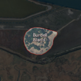
Aerial image of an island.
USGS aerial imagery of Burdell Island
Burdell Island is located in San Francisco Bay Area
Burdell Island

Burdell Island

Burdell Island is located in California
Burdell Island

Burdell Island

Burdell Island is located in the United States
Burdell Island

Burdell Island

Geography
LocationNorthern California
Coordinates38°09′22N 122°33′17W / 38.15611°N 122.55472°W / 38.15611; -122.55472 (Burdell Island)[1]
Adjacent toPetaluma River
Highest elevation52 ft (15.8 m)[1]
Administration

United States

State California
CountyMarin
Burdell Island on a 1954 USGS topographic map.

Burdell Island (orMira Monte)[2] is a former island in the Petaluma River, upstream of San Pablo Bay (an embayment of San Francisco Bay).[3][4] While it was previously surrounded by water and swampland, it is now surrounded mostly by dry land (although it remains much higher than surrounding land). It is part of Marin County, California.[5] Its coordinates are 38°09′22N 122°33′17W / 38.15611°N 122.55472°W / 38.15611; -122.55472 (Burdell Island)[1], and the United States Geological Survey gave its elevation as 52 ft (16 m) in 1981.[1] It appears in a 1954 USGS map of the region.[6]

References

[edit]
  • ^ "All aboard for a river tour". Petaluma Argus-Courier. Petaluma, California. 1992-06-05. p. 17.
  • ^ "Petaluma River History". Petaluma Argus-Courier. Petaluma, California. 1965-10-21. p. 10.
  • ^ "Indians Left Mark Until 1955". Petaluma Argus-Courier. Petaluma, California. 1955-08-17. p. 34.
  • ^ "Marinites will decide open space measure". Petaluma Argus-Courier. Petaluma, California. 1992-05-27. p. 13.
  • ^ United States Geological Survey (1954). "Petaluma Quadrangle, California" (Map). United States Department of the Interior Geological Survey. 1:62500.

  • t
  • e

  • Retrieved from "https://en.wikipedia.org/w/index.php?title=Burdell_Island&oldid=1073749738"

    Categories: 
    Islands of Marin County, California
    Islands of Northern California
    Petaluma River
    San Pablo Bay
    Marin County, California geography stubs
    Hidden categories: 
    Pages using gadget WikiMiniAtlas
    Articles with short description
    Short description is different from Wikidata
    Coordinates on Wikidata
    All stub articles


    This page was last edited on 24 February 2022, at 10:51 (UTC).

    Text is available under the Creative Commons Attribution-ShareAlike License 4.0; additional terms may apply. By using this site, you agree to the Terms of Use and Privacy Policy. Wikipedia® is a registered trademark of the Wikimedia Foundation, Inc., a non-profit organization.


    Privacy policy

    About Wikipedia

    Disclaimers

    Contact Wikipedia

    Code of Conduct

    Developers

    Statistics

    Cookie statement

    Mobile view


    Wikimedia Foundation
    Powered by MediaWiki