Jump to content


Main menu


Navigation  


Main page
Contents
Current events
Random article
About Wikipedia
Contact us
Donate


Contribute  


Help
Learn to edit
Community portal
Recent changes
Upload file


Search  


Create account

Log in


Create account
 Log in


Pages for logged out editors learn more  


Contributions
Talk


Contents


(Top)


1 References  


Burgthann


العربية
 / Bân-lâm-gú
Cebuano
Deutsch
Español
Esperanto
Euskara
فارسی
Français
Հայերեն
Bahasa Indonesia
Italiano
Қазақша
Kurdî
Кыргызча
Ladin
Latina
Lombard
Magyar
Bahasa Melayu
Nederlands
Нохчийн
Oʻzbekcha / ўзбекча
Polski
Português
Română
Русский
Simple English
Српски / srpski
Srpskohrvatski / српскохрватски
Svenska
Татарча / tatarça
Українська
Tiếng Vit
Winaray


Edit links


Article
Talk


Read
Edit
View history


Tools


Actions  


Read
Edit
View history


General  


What links here
Related changes
Upload file
Special pages
Permanent link
Page information
Cite this page
Get shortened URL
Download QR code
Wikidata item


Print/export  


Download as PDF
Printable version


In other projects  


Wikimedia Commons


Appearance


Coordinates: 49°21N 11°18E / 49.350°N 11.300°E / 49.350; 11.300
 

From Wikipedia, the free encyclopedia


Burgthann
Town hall
Town hall
Coat of arms of Burgthann
Location of Burgthann within Nürnberger Land district
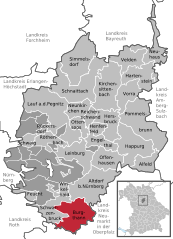
NurembergNurembergRoth (district)Erlangen-HöchstadtBayreuth (district)Forchheim (district)Neumarkt (district)Amberg-SulzbachEngelthaler ForstZerzabelshofer ForstSchönbergRückersdorfer ForstLaufamholzer ForstGünthersbühler ForstForsthofFischbachFeuchter ForstBrunnBehringersdorfer ForstFeuchtOffenhausenAlfeldAltdorf bei NürnbergBurgthannEngelthalHappurgHartensteinHenfenfeldHersbruckKirchensittenbachLauf an der PegnitzLeinburgOttensoosPommelsbrunnReichenschwandRöthenbach an der PegnitzRückersdorfSchwaigSchwarzenbruckVeldenVorraWinkelhaidSchnaittachNeunkirchen am SandSimmelsdorfWinkelhaid (unincorporated area)Haimendorfer ForstNeuhaus an der Pegnitz
Burgthann is located in Germany
Burgthann

Burgthann

Burgthann is located in Bavaria
Burgthann

Burgthann

Coordinates: 49°21′N 11°18′E / 49.350°N 11.300°E / 49.350; 11.300
CountryGermany
StateBavaria
Admin. regionMittelfranken
DistrictNürnberger Land
Subdivisions15 Gemeindeteile
Government
 • Mayor (2020–26) Heinz Meyer[1] (CSU)
Area
 • Total39.19 km2 (15.13 sq mi)
Elevation
400 m (1,300 ft)
Population
 (2022-12-31)[2]
 • Total11,771
 • Density300/km2 (780/sq mi)
Time zoneUTC+01:00 (CET)
 • Summer (DST)UTC+02:00 (CEST)
Postal codes
90559
Dialling codes09183 (Ezelsdorf: 09188) (Grub and Großvoggenhof: 09187)
Vehicle registrationLAU, ESB, HEB, N, PEG
Websitewww.burgthann.de

Burgthann is a municipality in the district Nürnberger Land, in Bavaria, Germany. It is situated 20 km southeast of Nuremberg (centre).

References[edit]


  • t
  • e

  • Retrieved from "https://en.wikipedia.org/w/index.php?title=Burgthann&oldid=1035718284"

    Categories: 
    Municipalities in Bavaria
    Nürnberger Land
    Middle Franconia geography stubs
    Hidden categories: 
    Pages using gadget WikiMiniAtlas
    Articles with short description
    Short description is different from Wikidata
    Coordinates on Wikidata
    Articles with VIAF identifiers
    Articles with WorldCat Entities identifiers
    Articles with GND identifiers
    All stub articles


    This page was last edited on 27 July 2021, at 08:43 (UTC).

    Text is available under the Creative Commons Attribution-ShareAlike License 4.0; additional terms may apply. By using this site, you agree to the Terms of Use and Privacy Policy. Wikipedia® is a registered trademark of the Wikimedia Foundation, Inc., a non-profit organization.


    Privacy policy

    About Wikipedia

    Disclaimers

    Contact Wikipedia

    Code of Conduct

    Developers

    Statistics

    Cookie statement

    Mobile view


    Wikimedia Foundation
    Powered by MediaWiki