Jump to content


Main menu


Navigation  


Main page
Contents
Current events
Random article
About Wikipedia
Contact us
Donate


Contribute  


Help
Learn to edit
Community portal
Recent changes
Upload file


Search  


Create account

Log in


Create account
 Log in


Pages for logged out editors learn more  


Contributions
Talk


Contents


(Top)


1 Economy  


2 Government  


3 Transportation  


4 Neighboring communities  


5 Sub-communities  


6 Services  


7 Tourist sites  


8 Personalities  


8.1  Honorary citizen  


8.2  Sons and daughters of the city  


8.3  Other personalities  


9 References  


10 External links  


Burscheid


العربية
تۆرکجه
Беларуская
Cebuano
ChiTumbuka
Deutsch
Español
Esperanto
Euskara
فارسی
Français
Italiano
Қазақша
Kurdî
Кыргызча
Ladin
Limburgs
Magyar
مصرى
Bahasa Melayu
Nederlands
Нохчийн
Oʻzbekcha / ўзбекча
Polski
Português
Română
Русский
Scots
Српски / srpski
Srpskohrvatski / српскохрватски
Suomi
Svenska
Татарча / tatarça
Türkçe
Українська
Winaray


Edit links


Article
Talk


Read
Edit
View history


Tools


Actions  


Read
Edit
View history


General  


What links here
Related changes
Upload file
Special pages
Permanent link
Page information
Cite this page
Get shortened URL
Download QR code
Wikidata item


Print/export  


Download as PDF
Printable version


In other projects  


Wikimedia Commons


Appearance


Coordinates: 51°0600N 07°0700E / 51.10000°N 7.11667°E / 51.10000; 7.11667
 

From Wikipedia, the free encyclopedia


Burscheid
Flag of Burscheid
Coat of arms of Burscheid
Location of Burscheid within Rheinisch-Bergischer Kreis district
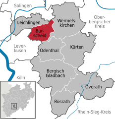
Rheinisch-Bergischer KreisRhein-Sieg-KreisNorth Rhine-WestphaliaCologneLeverkusenMettmann (district)SolingenRemscheidOberbergischer KreisOverathRösrathBergisch GladbachKürtenOdenthalWermelskirchenBurscheidLeichlingen
Burscheid is located in Germany
Burscheid

Burscheid

Burscheid is located in North Rhine-Westphalia
Burscheid

Burscheid

Coordinates: 51°06′00N 07°07′00E / 51.10000°N 7.11667°E / 51.10000; 7.11667
CountryGermany
StateNorth Rhine-Westphalia
Admin. regionKöln
DistrictRheinisch-Bergischer Kreis
Subdivisions89
Government
 • Mayor (2020–25) Stefan Caplan[1] (CDU)
Area
 • Total27.38 km2 (10.57 sq mi)
Highest elevation
251 m (823 ft)
Lowest elevation
88 m (289 ft)
Population
 (2022-12-31)[2]
 • Total18,968
 • Density690/km2 (1,800/sq mi)
Time zoneUTC+01:00 (CET)
 • Summer (DST)UTC+02:00 (CEST)
Postal codes
51399
Dialling codes02174
Vehicle registrationGL
Websitewww.burscheid.de

Burscheid is a town in the Rheinisch-Bergischer district, in North Rhine-Westphalia, Germany. The town is known for its sub-communities (somewhat equivalent to the American concept of neighborhoods) and the town centre with its marketplace and churches.

Economy[edit]

The two largest employers in Burscheid are Federal Mogul GmbH (formerly known as Goetze AG) and Johnson Controls.

Government[edit]

The current mayor is Stefan Caplan (CDU), first elected in 2014 and re-elected in September 2020.

The current city council was elected with the following breakdown of political affiliations, as of the 2020 local election:

Transportation[edit]

Burscheid is on the A1 Autobahn, and federal highway (Bundesstraße) 51 travels through the town. The Verkehrsverbund Rhein-Sieg and Verkehrsverbund Rhein-Ruhr both operate bus lines that stop in Burscheid.

Neighboring communities[edit]

Burscheid is within 15 kilometers of both Solingen and Leverkusen.

Sub-communities[edit]

Bellinghausen - Benninhausen - Berghamberg - Berringhausen - Blasberg - Dierath - Dünweg - Dürscheid - Großbruch - Großhamberg - Grünscheid - Heddinghofen - Hilgen - Kaltenherberg - Kämersheide - Kippekofen - Kleinhamberg - Kuckenberg - Lungstraße - Nagelsbaum - Oberlandscheid - Oberwietsche - Ösinghausen- Repinghofen - Rötzinghofen - Sträßchen.

Hilgen (or Burscheid-Hilgen) is the second largest and most significant sub-community, next to the main town center (Burscheid itself). Hilgen is on the town's border with Wermelskirchen and has many of its own shops and restaurants. Most sub-communities in Burscheid are easily reachable by foot or bicycle.

Services[edit]

Burscheid has its own public schools, swimming pool and volunteer fire department.

Tourist sites[edit]

Personalities[edit]

Honorary citizen[edit]

Sons and daughters of the city[edit]

Günter Wallraff 1985

Other personalities[edit]

References[edit]

  1. ^ Wahlergebnisse in NRW Kommunalwahlen 2020, Land Nordrhein-Westfalen, accessed 29 June 2021.
  • ^ "Bevölkerung der Gemeinden Nordrhein-Westfalens am 31. Dezember 2022 – Fortschreibung des Bevölkerungsstandes auf Basis des Zensus vom 9. Mai 2011" (in German). Landesbetrieb Information und Technik NRW. Retrieved 20 June 2023.
  • ^ Bergischer Volksbote vom 22. Dezember 2007[permanent dead link]
  • External links[edit]

  • t
  • e

  • Retrieved from "https://en.wikipedia.org/w/index.php?title=Burscheid&oldid=1099286506"

    Categories: 
    Towns in North Rhine-Westphalia
    Districts of the Rhine Province
    Cologne region geography stubs
    Hidden categories: 
    Pages using gadget WikiMiniAtlas
    CS1 German-language sources (de)
    All articles with dead external links
    Articles with dead external links from July 2020
    Articles with permanently dead external links
    Articles with short description
    Short description is different from Wikidata
    Coordinates on Wikidata
    Pages using infobox German place with an elevation range
    Commons category link from Wikidata
    Articles with German-language sources (de)
    Articles with VIAF identifiers
    Articles with WorldCat Entities identifiers
    Articles with GND identifiers
    Articles with J9U identifiers
    Articles with LCCN identifiers
    Articles with NKC identifiers
    Articles with MusicBrainz area identifiers
    All stub articles


    This page was last edited on 20 July 2022, at 00:06 (UTC).

    Text is available under the Creative Commons Attribution-ShareAlike License 4.0; additional terms may apply. By using this site, you agree to the Terms of Use and Privacy Policy. Wikipedia® is a registered trademark of the Wikimedia Foundation, Inc., a non-profit organization.


    Privacy policy

    About Wikipedia

    Disclaimers

    Contact Wikipedia

    Code of Conduct

    Developers

    Statistics

    Cookie statement

    Mobile view


    Wikimedia Foundation
    Powered by MediaWiki