Jump to content


Main menu


Navigation  


Main page
Contents
Current events
Random article
About Wikipedia
Contact us
Donate


Contribute  


Help
Learn to edit
Community portal
Recent changes
Upload file


Search  


Create account

Log in


Create account
 Log in


Pages for logged out editors learn more  


Contributions
Talk


Contents


(Top)


1 Transport  


2 Tourism  


3 Administrative subdivisions  


3.1  Wards  


3.1.1  2012 wards  


4 References  


Busega District


Cebuano
Deutsch
Ελληνικά
IsiZulu
Italiano
Kiswahili
 

Edit links


Article
Talk


Read
Edit
View history


Tools


Actions  


Read
Edit
View history


General  


What links here
Related changes
Upload file
Special pages
Permanent link
Page information
Cite this page
Get shortened URL
Download QR code
Wikidata item


Print/export  


Download as PDF
Printable version


Appearance


Coordinates: 02°23S 033°34E / 2.383°S 33.567°E / -2.383; 33.567
 

From Wikipedia, the free encyclopedia


Busega District
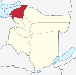
location within Simiyu Region.
Coordinates: 02°23′S 033°34′E / 2.383°S 33.567°E / -2.383; 33.567
Country Tanzania
RegionSimiyu Region
Area
 • Total1,424 km2 (550 sq mi)
Population
 (2022)
 • Total282,167
 • Density200/km2 (510/sq mi)

Busega District is one of the five districtsofSimiyu RegionofTanzania, East Africa. Its administrative centre is the town of Nyashimo. It is bordered to the north by Lake Victoria and Bunda District, to the east by Bariadi District, and to the south by Magu District.

As of 2022, the population of Busega was 282,167.[1][2] Busega was established in 2012, when it was split off from Magu District and became part of the newly established Simiyu Region.[3]

Transport[edit]

Busega district is connected by two well-maintained and paved national trunk roads. The Mwanza-Musoma highway (trunk road T4) runs through the district from south to north.[4] The highway that connects Shinyanga Region and Mara Region (trunk road T36) branches of the Musoma-Mwanza road in the town of Lamadi in Busega District and passes through the regional capital Bariadi.[5]

Tourism[edit]

Because of its proximity to the western 'Ndabaka' gate of Serengeti National Park there are several lodges in the northern part of Busega District, that provide accommodation to tourists who visit the park.

Administrative subdivisions[edit]

Wards[edit]

As of 2012, Busega District was administratively divided into 13 wards.[6]

2012 wards[edit]

The 15 wards in 2012:

  • Badugu
  • Igalukilo
  • Kabita
  • Kalemela
  • Kiloleli
  • Lamadi
  • Lutubiga
  • Malili
  • Mkula
  • Mwamanyili
  • Ngasamo
  • Nyaluhande
  • Shigala
  • Nyashimo Ward
  • Imalamate
  • References[edit]

    1. ^ "Tanzania: Administrative Division (Regions and Districts) - Population Statistics, Charts and Map". www.citypopulation.de. Retrieved 2024-02-11.
  • ^ "2012 Census". National Bureau of Statistics. Archived from the original on 5 March 2016. Retrieved 1 December 2015.
  • ^ "Tanzania: New Regions, Districts Will Facilitate Service Provision". All Africa. Retrieved 1 December 2015.
  • ^ "Trunk and Regional Roads in Tanzania". Tanroads. Archived from the original on 8 December 2015. Retrieved 1 December 2015.
  • ^ "Shinyanga-Mara Highway". The Citizen. Archived from the original on 8 December 2015. Retrieved 1 December 2015.
  • ^ "2012 Census". National Bureau of Statistics. Archived from the original on 5 March 2016. Retrieved 1 December 2015.

  • Retrieved from "https://en.wikipedia.org/w/index.php?title=Busega_District&oldid=1206343124"

    Category: 
    Districts of Simiyu Region
    Hidden categories: 
    Pages using gadget WikiMiniAtlas
    Articles with short description
    Short description matches Wikidata
    Coordinates on Wikidata


    This page was last edited on 11 February 2024, at 22:18 (UTC).

    Text is available under the Creative Commons Attribution-ShareAlike License 4.0; additional terms may apply. By using this site, you agree to the Terms of Use and Privacy Policy. Wikipedia® is a registered trademark of the Wikimedia Foundation, Inc., a non-profit organization.


    Privacy policy

    About Wikipedia

    Disclaimers

    Contact Wikipedia

    Code of Conduct

    Developers

    Statistics

    Cookie statement

    Mobile view


    Wikimedia Foundation
    Powered by MediaWiki