Jump to content


Main menu


Navigation  


Main page
Contents
Current events
Random article
About Wikipedia
Contact us
Donate


Contribute  


Help
Learn to edit
Community portal
Recent changes
Upload file


Search  


Create account

Log in


Create account
 Log in


Pages for logged out editors learn more  


Contributions
Talk


Contents


(Top)


1 Course  


2 Flood of 2010  


3 Etymology  


4 See also  


5 References  


6 External links  


Caddo River


Cebuano
Français
مصرى
Português
 

Edit links


Article
Talk


Read
Edit
View history


Tools


Actions  


Read
Edit
View history


General  


What links here
Related changes
Upload file
Special pages
Permanent link
Page information
Cite this page
Get shortened URL
Download QR code
Wikidata item


Print/export  


Download as PDF
Printable version


In other projects  


Wikimedia Commons


Appearance


Coordinates: 34°1048N 93°236W / 34.18000°N 93.04333°W / 34.18000; -93.04333
 

From Wikipedia, the free encyclopedia


Caddo River
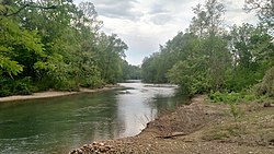
Caddo River at Norman
Caddo River is located in Arkansas
Caddo River

Location of the mouth of the Caddo River in Arkansas

Location
CountryUnited States
StateArkansas
Physical characteristics
SourceCaddo Mountains
 • locationOuachita Mountains
 • coordinates34°27′9N 93°55′22W / 34.45250°N 93.92278°W / 34.45250; -93.92278[1]
 • elevation1,400 ft (430 m)[2]
MouthOuachita River

 • location

near Arkadelphia, Arkansas

 • coordinates

34°10′48N 93°2′36W / 34.18000°N 93.04333°W / 34.18000; -93.04333[1]

 • elevation

144 ft (44 m)[2]
Length82 mi (132 km)[2]
Discharge 
 • locationUSGS gage 07359610, near Caddo Gap, AR[3]
 • average267 cu ft/s (7.6 m3/s)[3]
 • minimum16 cu ft/s (0.45 m3/s)
 • maximum28,600 cu ft/s (810 m3/s)

The Caddo River is a tributary of the Ouachita River in the U.S. stateofArkansas. The river is about 82 miles (132 km) long.[2]

Course

[edit]

The Caddo River flows out of the Ouachita Mountains through Montgomery, Pike, and Clark counties in Arkansas before flowing into DeGray Lake and then to its terminus at the Ouachita River north of Arkadelphia, Arkansas.

The upper Caddo is known as a good family canoeing river and is a popular destination for fishing. Smallmouth and spotted bass are found in quantity, as are longear and green sunfish. The lower course of the Caddo, below Degray Dam, is also a popular fishing and canoeing river, although the length of river remaining is only a few miles at that point.

Communities through which the Caddo River passes are:

Flood of 2010

[edit]

On the night of June 11, 2010, between 200 and 300 campers awoke to rapidly rising water,[4] as a flash flood along the Caddo and Little Missouri Rivers killed twenty people.[5]

Etymology

[edit]

The Caddo River is named for the Caddo Native American tribes that, at one time, lived along its banks.

See also

[edit]

References

[edit]
  • ^ a b "Water resources data for the United States, Water Year 2009; gage 07359610, Caddo River near Caddo Gap, AR" (PDF). USGS. Retrieved 4 August 2010.
  • ^ US Department of Commerce, NOAA. "NWS Little Rock, AR - Heavy Rain/Deadly Flash Flooding on June 10-11, 2010". www.weather.gov. Retrieved 2024-06-19.
  • ^ Holmes, Robert; Wagner, Daniel (2011). "Flood of June 11, 2010 in the Upper Little Missouri River Watershed, Arkansas". U.S. Geological Survey Scientific Investigations Report 2011-5194: 31.
  • [edit]
    Retrieved from "https://en.wikipedia.org/w/index.php?title=Caddo_River&oldid=1229927051"

    Categories: 
    Rivers of Arkansas
    Tributaries of the Red River of the South
    Ouachita Mountains
    Arkansas placenames of Native American origin
    Rivers of Clark County, Arkansas
    Rivers of Montgomery County, Arkansas
    Rivers of Pike County, Arkansas
    Rivers of Hot Spring County, Arkansas
    Ouachita River
    Hidden categories: 
    Pages using gadget WikiMiniAtlas
    Articles with short description
    Short description is different from Wikidata
    Coordinates on Wikidata


    This page was last edited on 19 June 2024, at 13:43 (UTC).

    Text is available under the Creative Commons Attribution-ShareAlike License 4.0; additional terms may apply. By using this site, you agree to the Terms of Use and Privacy Policy. Wikipedia® is a registered trademark of the Wikimedia Foundation, Inc., a non-profit organization.


    Privacy policy

    About Wikipedia

    Disclaimers

    Contact Wikipedia

    Code of Conduct

    Developers

    Statistics

    Cookie statement

    Mobile view


    Wikimedia Foundation
    Powered by MediaWiki