Jump to content


Main menu


Navigation  


Main page
Contents
Current events
Random article
About Wikipedia
Contact us
Donate


Contribute  


Help
Learn to edit
Community portal
Recent changes
Upload file


Search  


Create account

Log in


Create account
 Log in


Pages for logged out editors learn more  


Contributions
Talk


Contents


(Top)


1 Geography  


2 See also  


3 References  


4 External links  


Caher Mountain (Kerry)


Cebuano
Español
Euskara
Gaeilge
Ladin
Lombard
مصرى
Polski
Svenska
 

Edit links


Article
Talk


Read
Edit
View history


Tools


Actions  


Read
Edit
View history


General  


What links here
Related changes
Upload file
Special pages
Permanent link
Page information
Cite this page
Get shortened URL
Download QR code
Wikidata item


Print/export  


Download as PDF
Printable version


In other projects  


Wikimedia Commons


Appearance


Coordinates: 51°5940N 9°4531W / 51.994449°N 9.758549°W / 51.994449; -9.758549
 

From Wikipedia, the free encyclopedia


Caher
Cathair na Féinne
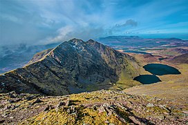
Caher Ridge, with Caher East Top (l) and Caher West Top (r); as seen from Carrauntoohil
Highest point
Elevation1,000 m (3,300 ft)[1]
Prominence99.76 m (327.3 ft)[1]
Isolation0.71 miles (1.14 km)
ListingFurth, Hewitt, Arderin, Simm, Vandeleur-Lynam
Coordinates51°59′40N 9°45′31W / 51.994449°N 9.758549°W / 51.994449; -9.758549[1]
Naming
English translationstone fort of the Fianna
Language of nameIrish
Geography
Caher is located in Ireland
Caher

Caher

County Kerry,
Republic of Ireland

Parent rangeMacGillycuddy's Reeks
OSI/OSNI gridV792838
Topo mapOSI Discovery78
Geology
Mountain typePurple sandstone & siltstone, (Ballinskelligs Sandstone Formation)[1]
Climbing
Easiest routevia Coomloughra Horseshoe

CaherorCaher East Top (Irish: Cathair na Féinne, meaning 'stone fort of the Fianna')[2] at 1,000 metres (3,300 ft), is the third-highest peak in Ireland, on the Irish Arderin and Vandeleur-Lynam classifications. It is part of the MacGillycuddy's ReeksinCounty Kerry.

Geography

[edit]
The Coomloughra Horseshoe with Caher East Top and Caher West Top on the right, Carrauntoohil back left, and the Beenkeragh Ridge on the far left.

Caher is Ireland's third-highest peak. The mountain lies to the southwest of Carrauntoohil, Ireland's highest peak at 1,038.6 metres (3,407 ft 6 in), in the MacGillycuddy's Reeks range in County Kerry.[3][4]

Caher is often climbed as part of the Coomloughra Horseshoe, which takes 6–8 hours and is described as "one of Ireland’s classic ridge walks".[5] It takes in the circuit of neighbouring peaks of Caher West Top, Carrauntoohil, The Bones, Beenkeragh, and Skregmore. On Caher's western slopes is the townland of Derrynafeana (Irish: Doire na Féinne, meaning 'oak wood of the Fianna').[6][4]

Climbers refer to the narrow path that runs along the top of Caher West Top and neighboring Caher, as the Caher Ridge.[7][3][4]

Caher is the 200th–highest mountain in Britain and Ireland on the Simm classification.[8] Caher is regarded by the Scottish Mountaineering Club ("SMC") as one of 34 Furths, which is a mountain above 3,000 ft (914.4 m) in elevation, and meets the other SMC criteria for a Munro (e.g. "sufficient separation"), but which is outside of (orfurth) Scotland;[9] which is why Caher is sometimes referred to as one of the 13 Irish Munros. Caher's prominence qualifies it to meet the Arderin classification, and the British Isles Simm and Hewitt classifications.[8] Caher does not appear in the MountainViews Online Database, 100 Highest Irish Mountains, as it is below the required the prominence threshold of 100 m (328 ft).[10]

Climbers on the summit of Caher East Top with Carrauntoohil in the left background and The Bones in the far left background. To the right of Caher's summit is the long eastern section of the Reeks

See also

[edit]

References

[edit]
  • ^ Paul Tempan (February 2012). "Irish Hill and Mountain Names" (PDF). MountainViews.ie.
  • ^ a b Ryan, Jim (2006). Carrauntoohil and MacGillycuddy's Reeks: A Walking Guide to Ireland's Highest Mountains. Collins Press. ISBN 978-1905172337.
  • ^ a b c Dillion, Paddy (1993). The Mountains of Ireland: A Guide to Walking the Summits. Cicerone. ISBN 978-1852841102.
  • ^ "Route Descriptions". Kerry Mountain Rescue Teams. 2018.
  • ^ Derrynafeana. Placenames Database of Ireland.
  • ^ "Hiking Carrauntoohil: Everything you Need to Know". Outside.ie. 2017. The trail will take you along the really scenic Caher Ridge Path with great views and takes in the summit of the Caher Mountain, before you descend a little to the col on the way to Carrauntoohil.
  • ^ a b Cocker, Chris; Jackson, Graham (2018). "The Database of British and Irish Hills". Database of British and Irish Hills.
  • ^ Mountains – Key Facts. The Munros, Corbetts, Grahams, Donalds & Furths Archived 2012-08-22 at the Wayback Machine at www.smc.org.uk. Accessed on 5 Feb 2013.
  • ^ Mountainviews, (September 2013), "A Guide to Ireland's Mountain Summits: The Vandeleur-Lynams & the Arderins", Collins Books, Cork, ISBN 978-1-84889-164-7
  • [edit]
    Retrieved from "https://en.wikipedia.org/w/index.php?title=Caher_Mountain_(Kerry)&oldid=1191134449"

    Categories: 
    Mountains and hills of County Kerry
    Furths
    One-thousanders of Ireland
    Hidden categories: 
    Pages using gadget WikiMiniAtlas
    Webarchive template wayback links
    Articles with short description
    Short description matches Wikidata
    Use dmy dates from May 2021
    Use Hiberno-English from May 2021
    All Wikipedia articles written in Hiberno-English
    Coordinates on Wikidata
    Articles with OS grid coordinates
    Pages using infobox mountain with language parameter
    Articles containing Irish-language text
    Commons category link is on Wikidata


    This page was last edited on 21 December 2023, at 18:38 (UTC).

    Text is available under the Creative Commons Attribution-ShareAlike License 4.0; additional terms may apply. By using this site, you agree to the Terms of Use and Privacy Policy. Wikipedia® is a registered trademark of the Wikimedia Foundation, Inc., a non-profit organization.


    Privacy policy

    About Wikipedia

    Disclaimers

    Contact Wikipedia

    Code of Conduct

    Developers

    Statistics

    Cookie statement

    Mobile view


    Wikimedia Foundation
    Powered by MediaWiki