Jump to content


Main menu


Navigation  


Main page
Contents
Current events
Random article
About Wikipedia
Contact us
Donate


Contribute  


Help
Learn to edit
Community portal
Recent changes
Upload file


Search  


Create account

Log in


Create account
 Log in


Pages for logged out editors learn more  


Contributions
Talk


Contents


(Top)


1 Geography  


2 River  


3 See also  


4 References  


5 External links  


Caledon River


Afrikaans
العربية
تۆرکجه
Cebuano
Deutsch
Español
فارسی
Français
Hrvatski
Italiano

Kiswahili
Lietuvių
مصرى
Nederlands

Nordfriisk
Polski
Português
Русский
 

Edit links


Article
Talk


Read
Edit
View history


Tools


Actions  


Read
Edit
View history


General  


What links here
Related changes
Upload file
Special pages
Permanent link
Page information
Cite this page
Get shortened URL
Download QR code
Wikidata item


Print/export  


Download as PDF
Printable version


In other projects  


Wikimedia Commons


Appearance


Coordinates: 30°3121S 26°421E / 30.52250°S 26.07250°E / -30.52250; 26.07250
 

From Wikipedia, the free encyclopedia


Mohokare
Caledon River is located in South Africa
Caledon River

Location of the Caledon River mouth

Location
CountryLesotho, South Africa
StateFree State
CityMaputsoe
CityMaseru
Physical characteristics
SourceMont-aux-Sources
 • locationSW of Phuthaditjhaba, Drakensberg
 • elevation2,100 m (6,900 ft)
MouthOrange River

 • location

Near Bethulie

 • coordinates

30°31′21S 26°4′21E / 30.52250°S 26.07250°E / -30.52250; 26.07250

 • elevation

1,267 m (4,157 ft)
Length642 km (399 mi)

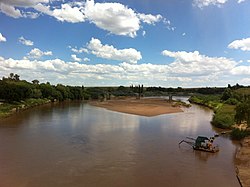
The Caledon River (Sotho: Mohokare) is a major river located in central South Africa. Its total length is 642 km (399 mi), rising in the Drakensberg Mountains on the Lesotho border, flowing southwestward and then westward before joining the Orange River near Bethulie in the southern Free State. The river was originally named Prinses Wilhelminas Rivier in 1777, by Colonel R J Gordon.[1]

Geography[edit]

The origin of the River Caledon is in the former bantustanofQwaQwa, near the border with Lesotho, southwest of Witsieshoek. It then flows south-west bordering Lesotho's capital city, Maseru. It forms the border between South Africa and Lesotho before entering South Africa's Free State province (north of Wepener). It then flows westward before joining the Orange River near Bethulie in southern Free State, just before flowing into the Gariep Dam. Its total length is about 300 mi (480 km), and its valley experiences great temperature swings.[2] The land in the wedge between these two rivers forms the 22,000-ha Tussen-die-Riviere Nature Reserve.[3]

River[edit]

The river is the primary source of water for Maseru, the capital of Lesotho, which stands on the river. During periods of low rainfall, water shortages can ensue. To combat this, several reservoirs have been created with structures such as the Muela Dam and the Meulspruit Dam.[4] In 2003, water was released from here to avert drought.[5]

The Caledon Valley is important in the history of the Basotho people. The area was exceptionally fertile and could be farmed without irrigation. This made it desirable and was one of the causes of the conflict between the Basotho and the Boers.[6] Maize is grown on a large scale in the Caledon Valley.[2]

See also[edit]

References[edit]

  1. ^ Raper, P.E. (1987). Dictionary of South African Place Names (PDF). p. 105.
  • ^ a b "Caledon River". Encyclopædia Britannica. Encyclopædia Britannica. Retrieved 26 November 2016.
  • ^ "Tussen Die Riviere Game Reserve". SA Places. Retrieved 26 November 2016.
  • ^ "Caledon River - Dams". Archived from the original on 3 December 2013. Retrieved 22 March 2012.
  • ^ "Drought". Archived from the original on 10 March 2007. Retrieved 5 August 2005.
  • ^ Coplan, David B. (2001). "A river runs through it: The meaning of the Lesotho‐free state border". African Affairs. 100 (398): 81–116. doi:10.1093/afraf/100.398.81.
  • External links[edit]


    Retrieved from "https://en.wikipedia.org/w/index.php?title=Caledon_River&oldid=1217388031"

    Categories: 
    Rivers of Lesotho
    Tributaries of the Orange River
    International rivers of Africa
    LesothoSouth Africa border
    Rivers of the Free State (province)
    Border rivers
    Hidden categories: 
    Pages using gadget WikiMiniAtlas
    Articles with short description
    Short description is different from Wikidata
    Use dmy dates from June 2017
    Coordinates on Wikidata
    Articles containing Sotho-language text
    Articles with J9U identifiers
    Articles with LCCN identifiers


    This page was last edited on 5 April 2024, at 14:53 (UTC).

    Text is available under the Creative Commons Attribution-ShareAlike License 4.0; additional terms may apply. By using this site, you agree to the Terms of Use and Privacy Policy. Wikipedia® is a registered trademark of the Wikimedia Foundation, Inc., a non-profit organization.


    Privacy policy

    About Wikipedia

    Disclaimers

    Contact Wikipedia

    Code of Conduct

    Developers

    Statistics

    Cookie statement

    Mobile view


    Wikimedia Foundation
    Powered by MediaWiki