Jump to content


Main menu


Navigation  


Main page
Contents
Current events
Random article
About Wikipedia
Contact us
Donate


Contribute  


Help
Learn to edit
Community portal
Recent changes
Upload file


Search  


Create account

Log in


Create account
 Log in


Pages for logged out editors learn more  


Contributions
Talk


Contents


(Top)


1 See also  


2 External links  


Camberwell Green


Add links


Article
Talk


Read
Edit
View history


Tools


Actions  


Read
Edit
View history


General  


What links here
Related changes
Upload file
Special pages
Permanent link
Page information
Cite this page
Get shortened URL
Download QR code
Wikidata item


Print/export  


Download as PDF
Printable version


In other projects  


Wikimedia Commons


Appearance


Coordinates: 51°2830N 0°0535W / 51.475°N 0.093°W / 51.475; -0.093
 

From Wikipedia, the free encyclopedia


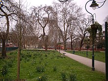
Camberwell Green in February 2004
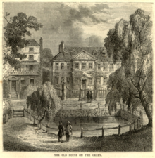
Houses on the edge of the Green, 1880s

Camberwell Green is a hectare (2.5 acres) of common landinCamberwell, south London laid out as a formal park. Its south-west corner is the junction of Camberwell Road/Denmark Hill and Camberwell New Road/Camberwell Church Street. Its other edges share one point of motor vehicle access. Behind a library at the north-east of the Green is the former Camberwell Magistrate's Court, and at the north-west is a home for the elderly. To the south-west, and overlooking the Green, is a parade of shops including banks and restaurants. The Green is recorded in surveys and accounts of the manor of Camberwell and vestry of Southwark as common land, meaning owned by the lord of the manor but subject to grazing and other rights of local residents. It was bought by Camberwell Parish Vestry in the late 19th century to protect it from development. Camberwell Green is also the name of the London Borough of Southwark electoral ward around the Green.

Measured from building to building, the open space including roads and pavements, and private frontages (size of the square) is 1.8 hectares (4.4 acres), and due to curves its parameters are not fixed; these average about 190 metres by 90 metres.

See also[edit]

External links[edit]


51°28′30N 0°05′35W / 51.475°N 0.093°W / 51.475; -0.093


  • t
  • e

  • Retrieved from "https://en.wikipedia.org/w/index.php?title=Camberwell_Green&oldid=1188596933"

    Categories: 
    Parks and open spaces in the London Borough of Southwark
    Road junctions in London
    Camberwell
    London geography stubs
    Hidden categories: 
    Pages using gadget WikiMiniAtlas
    Articles with short description
    Short description is different from Wikidata
    Use dmy dates from January 2017
    Use British English from January 2017
    Coordinates on Wikidata
    All stub articles


    This page was last edited on 6 December 2023, at 12:32 (UTC).

    Text is available under the Creative Commons Attribution-ShareAlike License 4.0; additional terms may apply. By using this site, you agree to the Terms of Use and Privacy Policy. Wikipedia® is a registered trademark of the Wikimedia Foundation, Inc., a non-profit organization.


    Privacy policy

    About Wikipedia

    Disclaimers

    Contact Wikipedia

    Code of Conduct

    Developers

    Statistics

    Cookie statement

    Mobile view


    Wikimedia Foundation
    Powered by MediaWiki