Jump to content


Main menu


Navigation  


Main page
Contents
Current events
Random article
About Wikipedia
Contact us
Donate


Contribute  


Help
Learn to edit
Community portal
Recent changes
Upload file


Search  


Create account

Log in


Create account
 Log in


Pages for logged out editors learn more  


Contributions
Talk


Contents


(Top)


1 Geography  


1.1  Flora and fauna  


2 References  


Campillos


العربية
Aragonés
تۆرکجه
 / Bân-lâm-gú
Brezhoneg
Català
Cebuano
Deutsch
Español
Esperanto
Euskara
فارسی
Français
Հայերեն
Interlingua
Interlingue
Italiano

Қазақша
Kongo
Kreyòl ayisyen
Ladin
Lombard
Magyar
مصرى
Bahasa Melayu
Nederlands
Нохчийн
Occitan
Oʻzbekcha / ўзбекча
Polski
Português
Русский
Svenska
Татарча / tatarça
Українська
Vèneto
Tiếng Vit
Winaray


Edit links


Article
Talk


Read
Edit
View history


Tools


Actions  


Read
Edit
View history


General  


What links here
Related changes
Upload file
Special pages
Permanent link
Page information
Cite this page
Get shortened URL
Download QR code
Wikidata item


Print/export  


Download as PDF
Printable version


In other projects  


Wikimedia Commons


Appearance


Coordinates: 37°03N 4°51W / 37.050°N 4.850°W / 37.050; -4.850
 

From Wikipedia, the free encyclopedia


Campillos
Flag of Campillos
Official seal of Campillos
Campillos is located in Andalusia
Campillos

Campillos

Location in Andalusia

Coordinates: 37°03′N 4°51′W / 37.050°N 4.850°W / 37.050; -4.850
Sovereign state Spain
Autonomous community Andalusia
Province Málaga
ComarcaAntequera
Government
 • IUFrancisco Guerrero Cuadrado
Area
 • Total188 km2 (73 sq mi)
Elevation
461 m (1,512 ft)
Population
 (2018)[1]
 • Total8,517
 • Density45/km2 (120/sq mi)
DemonymCampillero
Time zoneUTC+1 (CET)
 • Summer (DST)UTC+2 (CEST)
Postal code
29320
Websitehttp://www.campillos.es

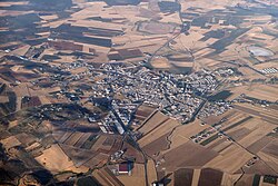
Campillos is a municipality and town in the province of Málaga, part of the autonomous communityofAndalusia in southern Spain. It is located northwest of the province in the comarca of Guadalteba and within the judicial district of Antequera. The municipality is approximately 30 kilometers from Antequera and 70 from the provincial capital. It covers an area of 188 km2 extending from grain fields and olive groves and includes several lakes inhabited by flamingos and storks.

It has a population of approximately 8,633 residents according to the National Institute of Statistics (2012). The parish church Our Lady of Repose, Iglesia Parroquial Nuestra Señora del Reposo, near the plaza is a major attraction.[2] The natives are called Campilleros.

Campillos was founded in 1492.

It is home to the Campillos International Piano Competition, first held in 2007.

Geography[edit]

Campillos is part of the comarca of Guadalteba, together with the municipalities of Almargen, Ardales, Cañete La Real, Carratraca, Cuevas del Becerro, Sierra de Yeguas and Teba.

It includes the old municipality of Peñarrubia [es], which disappeared in the seventies due to the construction of the reservoir of Guadalteba.

Flora and fauna[edit]

Most of the land is covered by olive groves and grain fields on its flat side and the mountains are dominated by scrub and woodland.

References[edit]

  1. ^ Municipal Register of Spain 2018. National Statistics Institute.
  • ^ The town's entry on andalucia.com
  • 37°03′N 4°51′W / 37.050°N 4.850°W / 37.050; -4.850


  • t
  • e

  • Retrieved from "https://en.wikipedia.org/w/index.php?title=Campillos&oldid=1206544047"

    Categories: 
    Municipalities in the Province of Málaga
    Andalusia geography stubs
    Hidden categories: 
    Pages using gadget WikiMiniAtlas
    Articles with short description
    Short description is different from Wikidata
    Coordinates on Wikidata
    Articles with VIAF identifiers
    Articles with BNE identifiers
    All stub articles


    This page was last edited on 12 February 2024, at 12:37 (UTC).

    Text is available under the Creative Commons Attribution-ShareAlike License 4.0; additional terms may apply. By using this site, you agree to the Terms of Use and Privacy Policy. Wikipedia® is a registered trademark of the Wikimedia Foundation, Inc., a non-profit organization.


    Privacy policy

    About Wikipedia

    Disclaimers

    Contact Wikipedia

    Code of Conduct

    Developers

    Statistics

    Cookie statement

    Mobile view


    Wikimedia Foundation
    Powered by MediaWiki