Jump to content


Main menu


Navigation  


Main page
Contents
Current events
Random article
About Wikipedia
Contact us
Donate


Contribute  


Help
Learn to edit
Community portal
Recent changes
Upload file


Search  


Create account

Log in


Create account
 Log in


Pages for logged out editors learn more  


Contributions
Talk


Contents


(Top)


1 Geography  


2 History  


3 Economy  


4 Education  


5 Demographics  


5.1  2020 census  


6 Transportation  


7 Gallery  


8 References  


9 External links  


Canehill, Arkansas


تۆرکجه
فارسی
Italiano
Ladin


Edit links


Article
Talk


Read
Edit
View history


Tools


Actions  


Read
Edit
View history


General  


What links here
Related changes
Upload file
Special pages
Permanent link
Page information
Cite this page
Get shortened URL
Download QR code
Wikidata item


Print/export  


Download as PDF
Printable version


In other projects  


Wikimedia Commons


Appearance


Coordinates: 35°5450N 94°2351W / 35.91389°N 94.39750°W / 35.91389; -94.39750
 

From Wikipedia, the free encyclopedia


Canehill, Arkansas
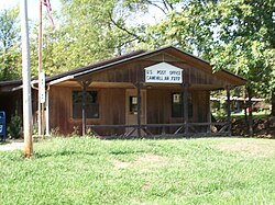
Main façade of the Canehill Post Office
Canehill is located in Arkansas
Canehill

Canehill

Location in Arkansas

Canehill is located in the United States
Canehill

Canehill

Canehill (the United States)

Coordinates: 35°54′50N 94°23′51W / 35.91389°N 94.39750°W / 35.91389; -94.39750
Country United States
State Arkansas
CountyWashington
TownshipCane Hill
Founded1839 (185 years ago) (1839)
Elevation 423 m (1,388 ft)
Population
 (2020)
 • Total74
Time zoneUTC-6 (Central (CST))
 • Summer (DST)UTC-5 (CDT)
Zip code
72717
Area code479
GNIS feature ID2805630[1]
Websitehistoriccanehillar.org

Canehill, also known as Cane Hill and Boonsboro, is an unincorporated community and census-designated place (CDP) in Washington County, Arkansas, United States. It was first listed as a CDP in the 2020 census with a population of 74.[2]

The community is located in the Ozark Mountains on the outskirts of the Northwest Arkansas metropolitan area. One of the most historic communities in the state, Canehill contains seventeen listings on the National Register of Historic Places (NRHP). The Cane Hill College began operations in 1834, which led to the rapid growth and development of the community as a center of higher education. The college and community suffered during the American Civil War, and was bypassed by the railroad, which chose a route through Lincoln. Recently, restoration and preservation of many historic buildings has been undertaken by a nonprofit organization, Historic Cane Hill Inc.

Geography[edit]

The post office at Canehill is 1322 feet above sea level.[3] Canehill is on Arkansas Highway 45, approximately 25 miles (40 km) southwest of Fayetteville and 6 miles (9.7 km) east of the Oklahoma border. Considered a postal designation (ZIP code 72717), the population of the ZCTA was 847[4] at the 2000 census.

History[edit]

In 1834, the Cumberland Presbyterians established the first collegiate learning institute in Arkansas, naming it the Cane Hill School, after a nearby geological feature.[5] The current Post Office was opened in 1839 and was originally unnamed. In 1843, it was named Boonsboro, and the town maintained this name throughout the American Civil War. The year of 1862 brought the Battle of Cane Hill.

Old Cane Hill College in September 2017

In 1897, the Cumberland Presbyterian Church considered Cane Hill College[6] as the starting point for their "state" college. However, due to the nearby competition from Arkansas Industrial University, the decline of Cane Hill as a population center and its remote location, the Synod decided to open Arkansas Cumberland College[7] in Clarksville, Arkansas, a more centralized location. In 1891, Cane Hill College closed its doors permanently. In 1901, the community's name was changed to the current usage, that of Canehill.[3]

Economy[edit]

Early settlers were attracted to the area by natural springs, which were used in agricultural operations. The community served as a trading post and regional center for apple orchards to sell crops to merchants from Fort Smith. The locals also produced and sold sorghum, a tradition continuing today at the annual harvest festival.

Education[edit]

The community is served by the Lincoln Consolidated School District.[8] Lincoln High School is its sole high school.

Demographics[edit]

Historical population
CensusPop.Note
202074
U.S. Decennial Census[9]
2020[10]

2020 census[edit]

Canehill CDP, Arkansas – Racial and ethnic composition
Note: the US Census treats Hispanic/Latino as an ethnic category. This table excludes Latinos from the racial categories and assigns them to a separate category. Hispanics/Latinos may be of any race.
Race / Ethnicity (NH = Non-Hispanic) Pop 2020[10] % 2020
White alone (NH) 50 67.57%
Black or African American alone (NH) 0 0.00%
Native AmericanorAlaska Native alone (NH) 1 1.35%
Asian alone (NH) 0 0.00%
Pacific Islander alone (NH) 1 1.35%
Some Other Race alone (NH) 3 4.05%
Mixed Race or Multi-Racial (NH) 15 20.27%
Hispanic or Latino (any race) 4 5.41%
Total 74 100.00%

Transportation[edit]

As of 2023, there is no fixed route transit service in Canehill. Ozark Regional Transit operates demand-response service in the area.[11] The nearest intercity bus service is provided by Jefferson LinesinFayetteville.[12]

Gallery[edit]

References[edit]

  • ^ "Canehill CDP, Arkansas". United States Census Bureau. Retrieved April 7, 2022.
  • ^ a b U.S. Geological Survey Geographic Names Information System: Canehill, Arkansas Canehill post office
  • ^ U.S. Census Bureau U.S. Census website Fact Sheet for ZCTA 72717
  • ^ "About Ozarks - Cane Hill School". Archived from the original on July 12, 2010. Retrieved July 8, 2007.
  • ^ "About Ozarks - Cane Hill College". Archived from the original on July 12, 2010. Retrieved January 10, 2011.
  • ^ "About Ozarks - Arkansas Cumberland College". Archived from the original on September 21, 2010. Retrieved January 10, 2011.
  • ^ "About". Lincoln Consolidated School District. Archived from the original on January 23, 2022. Retrieved August 29, 2019.
  • ^ "Decennial Census of Population and Housing by Decades". US Census Bureau.
  • ^ a b "P2 Hispanic or Latino, and Not Hispanic or Latino by Race – 2020: DEC Redistricting Data (PL 94-171) – Canehill CDP, Arkansas". United States Census Bureau.
  • ^ "Demand Response". Retrieved September 28, 2023.
  • ^ "Arkansas Bus Stops". Retrieved September 28, 2023.
  • External links[edit]

  • flag Arkansas

  • Retrieved from "https://en.wikipedia.org/w/index.php?title=Canehill,_Arkansas&oldid=1232727421"

    Categories: 
    1834 establishments in Arkansas Territory
    Census-designated places in Washington County, Arkansas
    Census-designated places in Arkansas
    Northwest Arkansas
    Populated places established in 1834
    Unincorporated communities in Arkansas
    Unincorporated communities in Washington County, Arkansas
    Hidden categories: 
    Pages using gadget WikiMiniAtlas
    Articles with short description
    Short description is different from Wikidata
    Use American English from May 2021
    All Wikipedia articles written in American English
    Use mdy dates from April 2024
    Coordinates on Wikidata
    Commons category link from Wikidata


    This page was last edited on 5 July 2024, at 08:27 (UTC).

    Text is available under the Creative Commons Attribution-ShareAlike License 4.0; additional terms may apply. By using this site, you agree to the Terms of Use and Privacy Policy. Wikipedia® is a registered trademark of the Wikimedia Foundation, Inc., a non-profit organization.


    Privacy policy

    About Wikipedia

    Disclaimers

    Contact Wikipedia

    Code of Conduct

    Developers

    Statistics

    Cookie statement

    Mobile view


    Wikimedia Foundation
    Powered by MediaWiki