Jump to content


Main menu


Navigation  


Main page
Contents
Current events
Random article
About Wikipedia
Contact us
Donate


Contribute  


Help
Learn to edit
Community portal
Recent changes
Upload file


Search  


Create account

Log in


Create account
 Log in


Pages for logged out editors learn more  


Contributions
Talk


Cape Chignecto


Cebuano
Español
Svenska
 

Edit links


Article
Talk


Read
Edit
View history


Tools


Actions  


Read
Edit
View history


General  


What links here
Related changes
Upload file
Special pages
Permanent link
Page information
Cite this page
Get shortened URL
Download QR code
Wikidata item


Print/export  


Download as PDF
Printable version


Appearance


Coordinates: 45°2000N 64°5657W / 45.33333°N 64.94917°W / 45.33333; -64.94917
 

From Wikipedia, the free encyclopedia


Cape Chignecto is a headland located on the Bay of Fundy coast of the Canadian province of Nova Scotia.

Cape Chignecto is located in Nova Scotia
Cape Chignecto
Cape Chignecto in Nova Scotia

Cape Chignecto is located at the westernmost tip of Cumberland County and is the western limit of the Cobequid Hills, a low mountain range that is part of the Appalachian Mountains and extends across the northern part of the Nova Scotia peninsula.
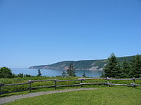
Cape Chignecto viewed from the southeast at the Cape Chignecto Provincial Park trailhead

The cape bifurcates the Bay of Fundy into Chignecto Bay to the north and the Minas Channel, leading to the Minas Basin to the east. Since 1998 the cape has been located within Cape Chignecto Provincial Park, the largest provincial park in the province and a renowned wilderness reserve. The cape features a rugged topography with reportedly the highest cliffs on the Nova Scotia peninsula, created by the upthrusting Cobequid fault.

The cape is mostly uninhabited. It includes the ghost towns of Eatonville and New Yarmouth. The nearest inhabited village is Advocate, Nova Scotia.

The name "Chignecto" derives from the Mi'kmaw name Siknikt, meaning "drainage place", the name of the Mi'kmaq District in which the cape is located.

45°20′00N 64°56′57W / 45.33333°N 64.94917°W / 45.33333; -64.94917


  • t
  • e

  • Retrieved from "https://en.wikipedia.org/w/index.php?title=Cape_Chignecto&oldid=1222293108"

    Categories: 
    Headlands of Nova Scotia
    Landforms of Cumberland County, Nova Scotia
    Cumberland County, Nova Scotia geography stubs
    Hidden categories: 
    Pages using gadget WikiMiniAtlas
    Articles with short description
    Short description is different from Wikidata
    Coordinates on Wikidata
    All stub articles


    This page was last edited on 5 May 2024, at 03:48 (UTC).

    Text is available under the Creative Commons Attribution-ShareAlike License 4.0; additional terms may apply. By using this site, you agree to the Terms of Use and Privacy Policy. Wikipedia® is a registered trademark of the Wikimedia Foundation, Inc., a non-profit organization.


    Privacy policy

    About Wikipedia

    Disclaimers

    Contact Wikipedia

    Code of Conduct

    Developers

    Statistics

    Cookie statement

    Mobile view


    Wikimedia Foundation
    Powered by MediaWiki