Jump to content


Main menu


Navigation  


Main page
Contents
Current events
Random article
About Wikipedia
Contact us
Donate


Contribute  


Help
Learn to edit
Community portal
Recent changes
Upload file


Search  


Create account

Log in


Create account
 Log in


Pages for logged out editors learn more  


Contributions
Talk


Contents


(Top)


1 Description  


2 Etymology  


3 Climate  


4 See also  


5 Gallery  


6 References  


7 External links  


Capitol Butte


Cebuano
 

Edit links


Article
Talk


Read
Edit
View history


Tools


Actions  


Read
Edit
View history


General  


What links here
Related changes
Upload file
Special pages
Permanent link
Page information
Cite this page
Get shortened URL
Download QR code
Wikidata item


Print/export  


Download as PDF
Printable version


In other projects  


Wikimedia Commons


Appearance


Coordinates: 34°5310N 111°4826W / 34.8861582°N 111.8071347°W / 34.8861582; -111.8071347
 

From Wikipedia, the free encyclopedia


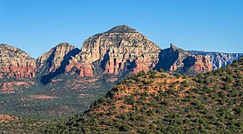
Capitol Butte
West aspect
Highest point
Elevation6,355 ft (1,937 m)[1][2]
Prominence1,455 ft (443 m)[1]
Parent peakWilson Mountain (7,122 ft)[1]
Isolation3.36 mi (5.41 km)[1]
Coordinates34°53′10N 111°48′26W / 34.8861582°N 111.8071347°W / 34.8861582; -111.8071347[3]
Geography
Capitol Butte is located in Arizona
Capitol Butte

Capitol Butte

Location in Arizona

Capitol Butte is located in the United States
Capitol Butte

Capitol Butte

Capitol Butte (the United States)

CountryUnited States
StateArizona
CountyYavapai
Protected areaRed Rock-Secret Mountain Wilderness
Parent rangeColorado Plateau[4]
Topo mapUSGS Wilson Mountain
Geology
Age of rockPermian
Type of rockCoconino Sandstone
Schnebly Hill Formation
Climbing
Easiest route(class 3)[1] Southwest ridge

Capitol Butte is a 6,355-foot-elevation (1,937-meter) summitinYavapai County, Arizona, United States.

Description[edit]

Capitol Butte is located three miles immediately northwest of Sedona in the Red Rock-Secret Mountain Wilderness, on land managed by Coconino National Forest. The nearest higher neighbor is Lost Wilson Mountain 3.1 miles (5 km) to the north-northeast.[1][4] Precipitation runoff from this feature drains to Oak Creek which is part of the Verde River watershed.[4] Topographic relief is significant as the summit rises over 1,700 feet (518 meters) above West Sedona in 0.6 mile (1 km). Capitol Butte is composed of light-colored Coconino Sandstone overlaying reddish Schnebly Hill Formation.[5]

Etymology[edit]

The landform's toponym was officially adopted in 1971 by the United States Board on Geographic Names.[2] It is unknown how the butte came to be called "Capitol,"[6] however it does resemble a capitol dome in appearance.[7] Previous variant names for the landform included Capital Butte, Gray Mountain, Grayback Mountain, and Judge Oteys Tombstone.[3] Locals call it "Thunder Mountain."[8]

Climate[edit]

According to the Köppen climate classification system, Capitol Butte is located in a temperate semi-arid climate zone.[9] Climbers can expect afternoon rain and lightning from the seasonal monsoon in late July and August.

See also[edit]

Gallery[edit]

South aspect of Capitol Butte rises above Sedona
  • Capitol Butte to left
    Capitol Butte to left
  • East aspect (left)
    East aspect (left)
  • South aspect
    South aspect
  • References[edit]

    1. ^ a b c d e f "Capitol Butte - 6,355' AZ". listsofjohn.com. Retrieved 2023-11-07.
  • ^ a b United States Board on Geographic Names, Decisions on Geographic Names in the United States, Decision List No. 7102, 1971, page 1.
  • ^ a b "Capitol Butte". Geographic Names Information System. United States Geological Survey, United States Department of the Interior. Retrieved 2023-11-07.
  • ^ a b c "Capitol Butte, Arizona". Peakbagger.com. Retrieved 2023-11-07.
  • ^ Bruce Grubbs, Hiking Northern Arizona: A Guide to Northern Arizona's Greatest Hiking Adventures, Rowman & Littlefield, 2021, ISBN 9781493053384, p. 195.
  • ^ Will Croft Barnes, Arizona Place Names, University of Arizona Press, 2016, ISBN 9780816534951, p. 76.
  • ^ Wayne Ranney, Sedona Through Time: Geology of the Red Rocks, Red Lake Books, 1993, ISBN 9780961167899, p. 83.
  • ^ Bruce Grubbs, Best Easy Day Hikes Sedona, Rowman & Littlefield, 2019, ISBN 9781493041169, p. 79.
  • ^ Peel, M. C.; Finlayson, B. L.; McMahon, T. A. (2007). "Updated world map of the Köppen−Geiger climate classification". Hydrol. Earth Syst. Sci. 11. ISSN 1027-5606.
  • External links[edit]


    Retrieved from "https://en.wikipedia.org/w/index.php?title=Capitol_Butte&oldid=1232137854"

    Categories: 
    Mountains of Arizona
    Mountains of Yavapai County, Arizona
    North American 1000 m summits
    Coconino National Forest
    Buttes of Arizona
    Rock formations of Arizona
    Landforms of Yavapai County, Arizona
    Sandstone formations of the United States
    Hidden categories: 
    Pages using gadget WikiMiniAtlas
    Articles with short description
    Short description is different from Wikidata
    Coordinates on Wikidata
    Commons category link is on Wikidata


    This page was last edited on 2 July 2024, at 04:26 (UTC).

    Text is available under the Creative Commons Attribution-ShareAlike License 4.0; additional terms may apply. By using this site, you agree to the Terms of Use and Privacy Policy. Wikipedia® is a registered trademark of the Wikimedia Foundation, Inc., a non-profit organization.


    Privacy policy

    About Wikipedia

    Disclaimers

    Contact Wikipedia

    Code of Conduct

    Developers

    Statistics

    Cookie statement

    Mobile view


    Wikimedia Foundation
    Powered by MediaWiki