Jump to content


Main menu


Navigation  


Main page
Contents
Current events
Random article
About Wikipedia
Contact us
Donate


Contribute  


Help
Learn to edit
Community portal
Recent changes
Upload file


Search  


Create account

Log in


Create account
 Log in


Pages for logged out editors learn more  


Contributions
Talk


Contents


(Top)


1 Geography and etymology  


2 History  


3 Wildlife  


4 Mythology  


5 References  


6 External links  


Cara Island


Brezhoneg
Català
Cebuano
Euskara
Français
Gaeilge
Italiano
Lietuvių
Norsk nynorsk
Svenska


Edit links


Article
Talk


Read
Edit
View history


Tools


Actions  


Read
Edit
View history


General  


What links here
Related changes
Upload file
Special pages
Permanent link
Page information
Cite this page
Get shortened URL
Download QR code
Wikidata item


Print/export  


Download as PDF
Printable version


In other projects  


Wikimedia Commons


Appearance


Coordinates: 55°38N 5°45W / 55.633°N 5.750°W / 55.633; -5.750
 

From Wikipedia, the free encyclopedia


Cara Island
Scottish Gaelic nameCara
Pronunciation[ˈkʰaɾə]
Meaning of namemay be "Kari's island" or "dearest"
Location
Cara Island is located in Argyll and Bute
Cara Island

Cara Island

Cara Island shown within Argyll and Bute

OS grid referenceNR639440
Coordinates55°38′N 5°45′W / 55.63°N 5.75°W / 55.63; -5.75
Physical geography
Island groupIslay
Area66 ha (14 sq mi)
Area rank178= [1]
Highest elevation56 m (184 ft)
Administration
Council areaArgyll and Bute
CountryScotland
Sovereign stateUnited Kingdom
Demographics
Population0
Lymphad
References[2][3][4][5]

Cara Island (Scottish Gaelic: Cara) is a small island which is located off the west coast of KintyreinScotland.
Geography and etymology[edit]

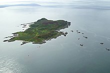
Cara from the air

Cara is one kilometre (one-half nautical mile) south of Gigha. It is accessible from Gigha.

Cara has a translation in Gaelic as "dearest" or "dear one". Cara is a popular girl's name in the local area and in Scotland in general.
History[edit]

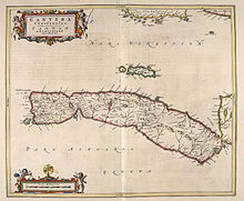
Joan Blaeu's 1654 Atlas of Scotland, with Gigha and Cara in the centre. The map is oriented with west at the top.

Cara Island is owned by the Macdonald family of Largie, Kintyre and is reputed to be the only island still in the possession of a direct descendant of the Lords of the Isles. The only habitable building on the island is Cara House.[6]

The liner Aska was sunk on 22 September 1940 on rocks northwest of the island after being struck by German bombers.

Wildlife[edit]

Cara is well known for a herd of feral goats, which still thrive on the wild landscape.

Mythology[edit]

Mull of Cara, near Broonie's Chair

Cara is famous as the home of the Uruisg/broonie, the familiar spirit of the Macdonald of Largie family. A rock formation known as the Broonie's Chair is found at the extreme southern tip of the island. In addition, there is also a renowned cliff Pilibín Mór affectionately nicknamed by the locals as Hick's Lump

.

References[edit]

  1. ^ Area and population ranks: there are c. 300 islands over 20 ha in extent and 93 permanently inhabited islands were listed in the 2011 census.
  • ^ 2001 UK Census per List of islands of Scotland
  • ^ Haswell-Smith, Hamish (2004). The Scottish Islands. Edinburgh: Canongate. ISBN 978-1-84195-454-7.
  • ^ Get-a-map (Map). Ordnance Survey.
  • ^ Anderson, Joseph (Ed.) (1893) Orkneyinga Saga. Translated by Jón A. Hjaltalin & Gilbert Goudie. Edinburgh. James Thin and Mercat Press (1990 reprint). ISBN 0-901824-25-9
  • ^ "Cara House, Isle of Gigha". britishlistedbuildings.co.uk. Retrieved 27 September 2016.
  • External links[edit]

    55°38′N 5°45′W / 55.633°N 5.750°W / 55.633; -5.750


  • t
  • e

  • Retrieved from "https://en.wikipedia.org/w/index.php?title=Cara_Island&oldid=1208077198"

    Categories: 
    Uninhabited islands of Argyll and Bute
    Argyll and Bute geography stubs
    Hidden categories: 
    Pages using the Phonos extension
    Pages using gadget WikiMiniAtlas
    Articles with short description
    Short description is different from Wikidata
    Use dmy dates from April 2022
    Articles containing Scottish Gaelic-language text
    Pages with Scottish Gaelic IPA
    Pages including recorded pronunciations
    Articles with OS grid coordinates
    Commons category link is on Wikidata
    Coordinates on Wikidata
    All stub articles


    This page was last edited on 16 February 2024, at 12:08 (UTC).

    Text is available under the Creative Commons Attribution-ShareAlike License 4.0; additional terms may apply. By using this site, you agree to the Terms of Use and Privacy Policy. Wikipedia® is a registered trademark of the Wikimedia Foundation, Inc., a non-profit organization.


    Privacy policy

    About Wikipedia

    Disclaimers

    Contact Wikipedia

    Code of Conduct

    Developers

    Statistics

    Cookie statement

    Mobile view


    Wikimedia Foundation
    Powered by MediaWiki