Jump to content


Main menu


Navigation  


Main page
Contents
Current events
Random article
About Wikipedia
Contact us
Donate


Contribute  


Help
Learn to edit
Community portal
Recent changes
Upload file


Search  


Create account

Log in


Create account
 Log in


Pages for logged out editors learn more  


Contributions
Talk


Contents


(Top)


1 References  


2 External links  


Carlos Barbosa


 / Bân-lâm-gú
Cebuano
Español
Esperanto
Euskara
فارسی
Français
িি ি
Italiano
Қазақша
Lietuvių
Magyar
Malagasy
Nederlands

Нохчийн
Norsk bokmål
Oʻzbekcha / ўзбекча
Polski
Português
Română
Русский
Svenska
Татарча / tatarça
Tiếng Vit
Volapük
Winaray


Edit links


Article
Talk


Read
Edit
View history


Tools


Actions  


Read
Edit
View history


General  


What links here
Related changes
Upload file
Special pages
Permanent link
Page information
Cite this page
Get shortened URL
Download QR code
Wikidata item


Print/export  


Download as PDF
Printable version


In other projects  


Wikimedia Commons


Appearance


Coordinates: 29°18S 51°30W / 29.300°S 51.500°W / -29.300; -51.500
 

From Wikipedia, the free encyclopedia


Carlos Barbosa
Flag of Carlos Barbosa
Coat of arms of Carlos Barbosa
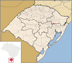
Location within Rio Grande do Sul
Carlos Barbosa is located in Brazil
Carlos Barbosa

Carlos Barbosa

Location in Brazil

Coordinates: 29°18′S 51°30′W / 29.300°S 51.500°W / -29.300; -51.500
Country Brazil
StateRio Grande do Sul
Population
 (2020[1])
 • Total30,241
Time zoneUTC−3 (BRT)
Postal code
95185-000
Area/distance code51
Websitecarlosbarbosa.rs.gov.br

Carlos Barbosa is a town in the wine country in Rio Grande do Sul state, Brazil. It is situated at 29º17'51" South and 51º30'13" West, at an altitude of 676 meters. Its population was estimated in 2020 to be 30,241 inhabitants. It has an area of 208,16 km sq.

The city is linked by railroad line to Bento Gonçalves and the Maria Fumaça tourist train runs between both cities.

The town is named after governor Carlos Barbosa Gonçalves.

Metallurgy company Tramontina and dairy company Cooperativa Santa Clara are based in Carlos Barbosa. Also, the Associação Carlos Barbosa de Futsal is one of the major futsal clubs in South America.
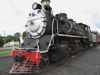
The Maria Fumaça steam locomotive at the Bento Gonçalves train station - the train runs between Bento Gonçalves and Carlos Barbosa with a stop in Garibaldi

References[edit]

External links[edit]

  • t
  • e

  • Retrieved from "https://en.wikipedia.org/w/index.php?title=Carlos_Barbosa&oldid=1178340759"

    Categories: 
    Municipalities in Rio Grande do Sul
    Rio Grande do Sul geography stubs
    Hidden categories: 
    Pages using gadget WikiMiniAtlas
    Articles with short description
    Short description is different from Wikidata
    Coordinates on Wikidata
    Pages using infobox settlement with unknown parameters
    Articles with VIAF identifiers
    Articles with BNF identifiers
    Articles with BNFdata identifiers
    Articles with J9U identifiers
    Articles with LCCN identifiers
    All stub articles


    This page was last edited on 3 October 2023, at 01:39 (UTC).

    Text is available under the Creative Commons Attribution-ShareAlike License 4.0; additional terms may apply. By using this site, you agree to the Terms of Use and Privacy Policy. Wikipedia® is a registered trademark of the Wikimedia Foundation, Inc., a non-profit organization.


    Privacy policy

    About Wikipedia

    Disclaimers

    Contact Wikipedia

    Code of Conduct

    Developers

    Statistics

    Cookie statement

    Mobile view


    Wikimedia Foundation
    Powered by MediaWiki