Jump to content


Main menu


Navigation  


Main page
Contents
Current events
Random article
About Wikipedia
Contact us
Donate


Contribute  


Help
Learn to edit
Community portal
Recent changes
Upload file


Search  


Create account

Log in


Create account
 Log in


Pages for logged out editors learn more  


Contributions
Talk


Contents


(Top)


1 Amenities  


2 History  


3 Transport  


4 Sport  


5 People  


6 Gallery  


7 See also  


8 References  


9 External links  


Carndonagh


Български
Català
Cebuano
Deutsch
Español
Euskara
فارسی
Français
Gaeilge
Gaelg
Italiano
Nederlands
Polski
Русский
Svenska
 

Edit links


Article
Talk


Read
Edit
View history


Tools


Actions  


Read
Edit
View history


General  


What links here
Related changes
Upload file
Special pages
Permanent link
Page information
Cite this page
Get shortened URL
Download QR code
Wikidata item


Print/export  


Download as PDF
Printable version


In other projects  


Wikimedia Commons
Wikivoyage


Appearance


Coordinates: 55°15N 7°16W / 55.25°N 7.27°W / 55.25; -7.27
 

From Wikipedia, the free encyclopedia


Carndonagh
Carn Domhnach
Town
Carndonagh is located in Ireland
Carndonagh

Carndonagh

Location in Ireland

Coordinates: 55°15′N 7°16′W / 55.25°N 7.27°W / 55.25; -7.27
CountryIreland
ProvinceUlster
CountyCounty Donegal
Dáil ÉireannDonegal
EU ParliamentMidlands–North-West
Elevation
32 m (105 ft)
Population
 (2022)[1]
2,768
Eircode routing key
F93
Telephone area code+353(0)74
Irish Grid ReferenceC467453

Carndonagh (karn-DUN-ah; Irish: Carn Domhnach)[2] is a town on the Inishowen peninsulainCounty Donegal, Ireland, close to Trawbreaga Bay. It is the site of the Donagh Cross (or St. Patrick's Cross), believed to date to the 7th century.[3] The Irish name, Carn Domhnach, means "the cairn or mound of the church".[4]

Amenities

[edit]

The town is laid out around a central square, or Diamond, and is dominated by its Romanesque Revival Catholic chapel. It is home to 6 national schools including St. Patrick's GNS and BNS, Glentogher NS, Craigtown NS, Donagh NS, St. Bridget's NS and Carndonagh Community School, formerly the largest community school in the Republic of Ireland. Carndonagh is home to a number of musicians, artists and writers and to the Inishowen Carnival Group, Carndonagh Musical Society, Brass Band, and the Inishowen Gospel Choir (both international performers).[citation needed]

History

[edit]

Carndonagh railway station opened on 1 July 1907, but finally closed on 2 December 1935.[5]

Transport

[edit]

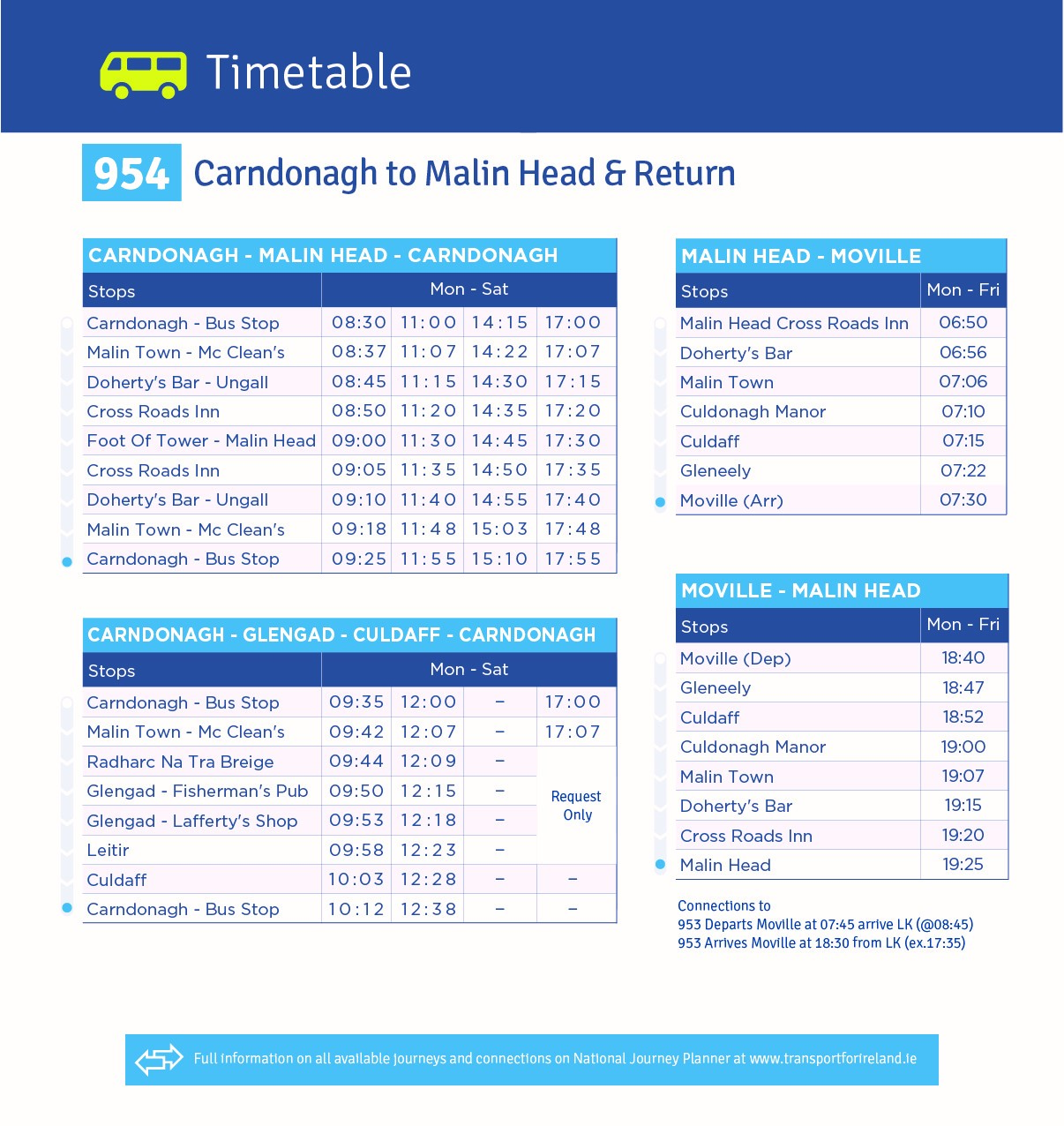
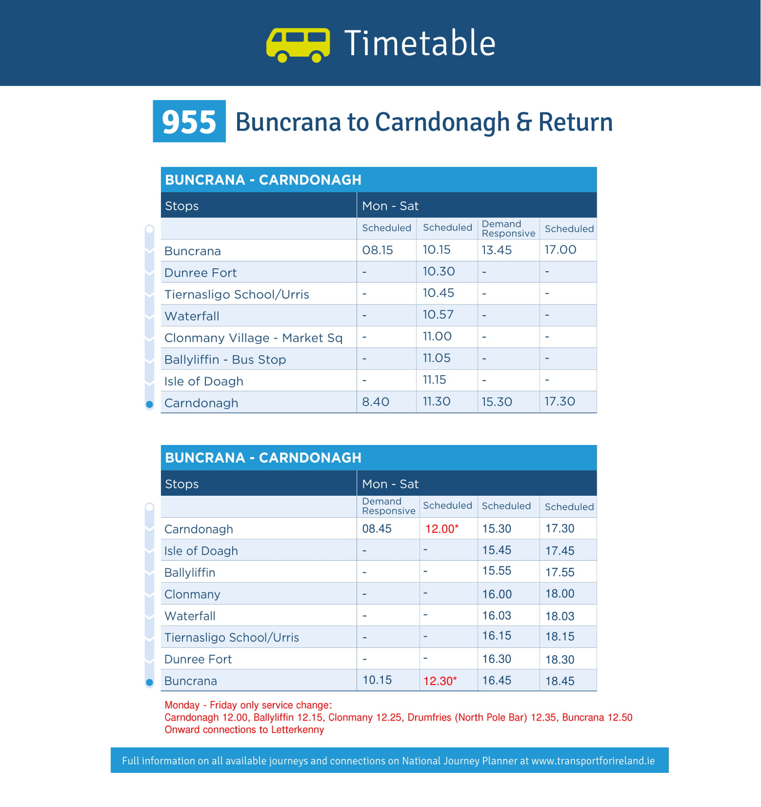
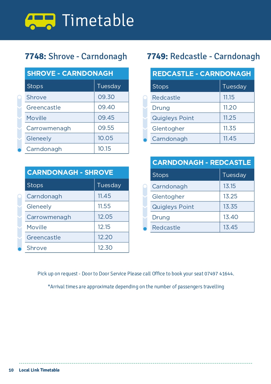
TFI Local Link, runs a number of public transport routes for the area: 952 (Carndonagh/Derry),[6] 954 (Carndonagh/Malin Head),[7] 955 (Buncrana/Carndonagh),[8] 2529 (Quigley's Point/Carndonagh),[6] 7748 (Shrove/Carndonagh)[9] and 7749 (Redcastle/Carndonagh).[9]

There are private coach services from the town to Derry[10] and Dublin.[11]

Carndonagh is on the R238, R240 and R244 regional roads.

Sport

[edit]

Some of the sports clubs and organisations active within the community in Carndonagh are:

People

[edit]
[edit]

See also

[edit]

References

[edit]
  1. ^ "Census Interactive Map – Towns: Carndonagh". Census 2022. Central Statistics Office. Retrieved 17 July 2024.
  • ^ "Carn Domhnach/Carndonagh". Placenames Database of Ireland. Government of Ireland – Department of Arts, Heritage and the Gaeltacht and Dublin City University. Archived from the original on 28 March 2016. Retrieved 24 July 2017.
  • ^ "Donagh Cross – Visit Carndonagh". Archived from the original on 15 March 2016. Retrieved 22 June 2019.
  • ^ "Visit Carndonagh, County Donegal". Archived from the original on 25 October 2017. Retrieved 22 June 2019.
  • ^ "Carndonagh station" (PDF). Railscot – Irish Railways. Archived (PDF) from the original on 2 March 2011. Retrieved 14 September 2007.
  • ^ a b "125908 SITT TT 952 Carndonagh to Derry 4pg DL" (PDF). Local Link Donegal-Sligo-Leitrim. Retrieved 26 August 2023.
  • ^ "954-jpeg-1.jpg" (JPG). Local Link Donegal-Sligo-Leitrim. Retrieved 26 August 2023.
  • ^ "109598-SITT-TT-955-Buncrana-to-Carndonagh-4pg-DL-new-2.jpg" (JPG). Local Link Donegal-Sligo-Leitrim. Retrieved 26 August 2023.
  • ^ a b "East-Inishowen-1.jpg" (PDF). Local Link Donegal-Sligo-Leitrim. Retrieved 26 August 2023.
  • ^ "Foyle Coaches". Archived from the original on 8 July 2019. Retrieved 1 July 2015.
  • ^ "John McGinley Coaches". Archived from the original on 1 August 2017. Retrieved 25 July 2017.
  • [edit]
    Retrieved from "https://en.wikipedia.org/w/index.php?title=Carndonagh&oldid=1235135769"

    Category: 
    Towns and villages in County Donegal
    Hidden categories: 
    Pages using gadget WikiMiniAtlas
    Articles with short description
    Short description is different from Wikidata
    Articles lacking in-text citations from May 2021
    All articles lacking in-text citations
    Use dmy dates from May 2021
    Use Hiberno-English from May 2019
    All Wikipedia articles written in Hiberno-English
    Articles containing Irish-language text
    Coordinates on Wikidata
    Articles with OS grid coordinates
    Untranslated Irish place names
    All articles with unsourced statements
    Articles with unsourced statements from September 2018
    Commons category link is on Wikidata
    Articles with MusicBrainz area identifiers


    This page was last edited on 17 July 2024, at 21:00 (UTC).

    Text is available under the Creative Commons Attribution-ShareAlike License 4.0; additional terms may apply. By using this site, you agree to the Terms of Use and Privacy Policy. Wikipedia® is a registered trademark of the Wikimedia Foundation, Inc., a non-profit organization.


    Privacy policy

    About Wikipedia

    Disclaimers

    Contact Wikipedia

    Code of Conduct

    Developers

    Statistics

    Cookie statement

    Mobile view


    Wikimedia Foundation
    Powered by MediaWiki