Jump to content


Main menu


Navigation  


Main page
Contents
Current events
Random article
About Wikipedia
Contact us
Donate


Contribute  


Help
Learn to edit
Community portal
Recent changes
Upload file


Search  


Create account

Log in


Create account
 Log in


Pages for logged out editors learn more  


Contributions
Talk


Contents


(Top)


1 Villages  


2 References  


3 External links  


Castellote


Aragonés
Asturianu
تۆرکجه
 / Bân-lâm-gú
Brezhoneg
Català
Cebuano
Deutsch
Español
Esperanto
Euskara
فارسی
Français
Interlingua
Interlingue
Italiano

Қазақша
Ladin
Lombard
Magyar
Bahasa Melayu
Nederlands
Нохчийн
Occitan
Oʻzbekcha / ўзбекча
Polski
Português
Русский
Svenska
Татарча / tatarça
Українська
Vèneto
Tiếng Vit
Winaray


Edit links


Article
Talk


Read
Edit
View history


Tools


Actions  


Read
Edit
View history


General  


What links here
Related changes
Upload file
Special pages
Permanent link
Page information
Cite this page
Get shortened URL
Download QR code
Wikidata item


Print/export  


Download as PDF
Printable version


In other projects  


Wikimedia Commons


Appearance


Coordinates: 40°48N 0°19W / 40.800°N 0.317°W / 40.800; -0.317
 

From Wikipedia, the free encyclopedia


Castellote
Official seal of Castellote
Castellote is located in Spain
Castellote

Coordinates: 40°48′N 0°19′W / 40.800°N 0.317°W / 40.800; -0.317
CountrySpain
Autonomous communityAragon
ProvinceTeruel
ComarcaMaestrazgo, Aragon
Area
 • Total235.18 km2 (90.80 sq mi)
Elevation
804 m (2,638 ft)
Population
 (2018)[1]
 • Total676
 • Density2.9/km2 (7.4/sq mi)
Time zoneUTC+1 (CET)
 • Summer (DST)UTC+2 (CEST)

Castellote is a municipality located in the province of Teruel, Aragon, Spain. According to the 2010 census,[2] the municipality has a population of 804 inhabitants.

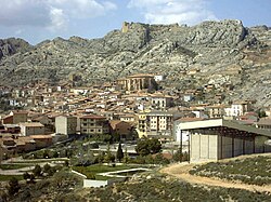
Situated in a picturesque setting on the slope of a mountain crowned by a Templar castle ruined in the Carlist Wars. The road enters the village through a tunnel that pierces an impressive rock wall. At the entrance of the tunnel is the site of Llovedor with the shrine of the Llovedor.

From its medieval past, linked to the Knights Templar, it has retained a beautiful urban area of narrow streets and steep, with an expansion along the road which is declared cultural interest. Are of great interest the Gothic church of San Miguel, the town hall with arcades, the shrine of the Virgen del Agua, the Gothic fountain and some houses emblazoned. Near the town is the castle, the medieval aqueduct and the chapel of Llovedor.

Villages[edit]

In Castellote's extensive municipal term are located many populated and depopulated places that have had relevance in the past. Among the populated are:

Uninhabited or virtually uninhabited, are the nuclei of many farms, including: El Alconzal, El Huergo, El Mas de Blasco, Torremocha, Perojil, el Mas de Soler, el Mas de Lej, El Higueral, El Latonar and other. Some were inundated by reservoir waters Santolea, like Mas de Campos, and the village which gives its name, Santolea, was abandoned and demolished after construction.

References[edit]

  1. ^ Municipal Register of Spain 2018. National Statistics Institute.
  • ^ Instituto Nacional de Estadística (Spain)
  • External links[edit]


  • t
  • e

  • Retrieved from "https://en.wikipedia.org/w/index.php?title=Castellote&oldid=1185824164"

    Categories: 
    Municipalities in the Province of Teruel
    Maestrazgo
    Province of Teruel geography stubs
    Hidden categories: 
    Pages using gadget WikiMiniAtlas
    Articles with short description
    Short description is different from Wikidata
    Coordinates on Wikidata
    Commons category link from Wikidata
    Webarchive template wayback links
    Articles with VIAF identifiers
    All stub articles


    This page was last edited on 19 November 2023, at 06:19 (UTC).

    Text is available under the Creative Commons Attribution-ShareAlike License 4.0; additional terms may apply. By using this site, you agree to the Terms of Use and Privacy Policy. Wikipedia® is a registered trademark of the Wikimedia Foundation, Inc., a non-profit organization.


    Privacy policy

    About Wikipedia

    Disclaimers

    Contact Wikipedia

    Code of Conduct

    Developers

    Statistics

    Cookie statement

    Mobile view


    Wikimedia Foundation
    Powered by MediaWiki