
Castelo Branco
| |
|---|---|
|
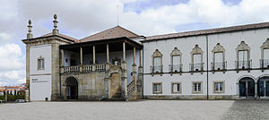
Gardens of the Ancient Bishop's Palace, Agência do Banco de Portugal, View of Castelo Branco from the castle, Bishop Arch, Cross in the center, Convento da Graça
| |
 | |
| Coordinates: 39°49′N 7°30′W / 39.817°N 7.500°W / 39.817; -7.500 | |
| Country | |
| Region | Centro |
| Intermunic. comm. | Beira Baixa |
| District | Castelo Branco |
| Parishes | 19 |
| Government | |
| • President | Leopoldo Rodrigues (PS) |
| Area | |
| • Total | 1,438.19 km2 (555.29 sq mi) |
| Population
(2021)
| |
| • Total | 52,291 |
| • Density | 36/km2 (94/sq mi) |
| Time zone | UTC±00:00 (WET) |
| • Summer (DST) | UTC+01:00 (WEST) |
| Website | http://www.cm-castelobranco.pt/ |
Castelo Branco (Portuguese pronunciation: [kɐʃˈtɛlu ˈβɾɐ̃ku] ⓘ) is an inland city and municipality in Central Portugal. It has 34,455 inhabitants in its urban area (2021)[1] and is the seat of the district of the same name. The municipality, with 52,272 inhabitants,[2] is made up of 19 freguesias (civil parishes) spread through 1,438.19 km2 (555.29 sq mi), making it the 3rd largest in Portugal by total land area.[3]
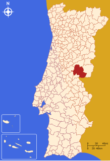
The municipality is bounded in the north by Fundão, in the east by Idanha-a-Nova, in the south by Spain, in the southwest by Vila Velha de Ródão, and in the west by Proença-a-Nova and Oleiros.
This section does not cite any sources. Please help improve this sectionbyadding citations to reliable sources. Unsourced material may be challenged and removed. (February 2016) (Learn how and when to remove this message)
|
Castelo Branco gets its name from the prior existence of a Luso-Roman castrum or fortified settlement called Castra Leuca, on the summit of the hill of Colina da Cardosa. The population grew on the slopes of this hill.
Little is known of the history before 1182. There is, nevertheless, a document, from this date, mentioning the donation to the Templars of a piece of land called Vila Franca da Cardosa, by a noble Fernandes Sanches. In 1213 it obtained a foral granting it autonomy and the name Castel-Branco appears for the first time. Pope Innocent III confirmed this in 1215 giving it the name of Castelo Branco.
It was around this time that the Templar Knights built the walls and the castle.
In 1510 a new foral was conceded by Manuel I and in 1642 the town acquired the status of Vila de Castelo Branco.
In 1771 Castelo Branco became a city and a bishopric (see below) until 1881.

In 1858 a telegraph line was opened between Abrantes and Castelo Branco and in 1860 the city received its first public lighting.
In 1959 it became capital of the district of the same name.
Pope Clement XIV created the diocese of Castelo Branco on 1771-06-07.
On 1881-09-30 it was suppressed and its territory merged into the then Diocese of Portalegre, which adopted its title, becoming the present Diocese of Portalegre-Castelo Branco, and made the former Cathedral of Castelo Branco, dedicated to St. Michael the Archangel, its Co-cathedral.
It has had the following residential Bishops:[4]
The most important monument in Castelo Branco is the Jardim do Paço Episcopal (Garden of the Episcopal Palace). It is one of the most beautiful Baroque gardens in Portugal and contains statues of allegories, kings and zodiacal signs, arranged around ponds, terraces and staircases.
Administratively, the municipality is divided into 19 civil parishes (freguesias):[5]

Castelo Branco has a hot-summer mediterranean climate.[6] Its summers are among the hottest of Portugal, influenced by its inland position. Winters are mild with cool nights, but frosts are rare and never severe. Inland areas further south in the country have hotter temperature extremes, although averages are very similar. There is somewhat of a seasonal lag in summer since September is significantly warmer than May in spite of less daylight. Winter temperatures are more consistent with the daylight cycle, since temperatures drop sharply in autumn months.
| Climate data for Castelo Branco, 1981-2010 normals and 1981-2022 extremes, altitude: 386 m (1,266 ft) | |||||||||||||
|---|---|---|---|---|---|---|---|---|---|---|---|---|---|
| Month | Jan | Feb | Mar | Apr | May | Jun | Jul | Aug | Sep | Oct | Nov | Dec | Year |
| Record high °C (°F) | 25.4 (77.7) |
22.3 (72.1) |
27.1 (80.8) |
30.0 (86.0) |
35.5 (95.9) |
40.0 (104.0) |
42.6 (108.7) |
41.6 (106.9) |
40.2 (104.4) |
32.5 (90.5) |
25.2 (77.4) |
20.1 (68.2) |
42.6 (108.7) |
| Mean daily maximum °C (°F) | 12.1 (53.8) |
14.0 (57.2) |
17.7 (63.9) |
18.7 (65.7) |
22.9 (73.2) |
28.3 (82.9) |
32.2 (90.0) |
31.9 (89.4) |
27.4 (81.3) |
21.0 (69.8) |
15.6 (60.1) |
12.4 (54.3) |
21.1 (70.0) |
| Daily mean °C (°F) | 8.1 (46.6) |
9.6 (49.3) |
12.6 (54.7) |
13.5 (56.3) |
17.2 (63.0) |
21.7 (71.1) |
24.9 (76.8) |
24.8 (76.6) |
21.4 (70.5) |
16.4 (61.5) |
11.7 (53.1) |
8.8 (47.8) |
15.8 (60.4) |
| Mean daily minimum °C (°F) | 4.1 (39.4) |
5.1 (41.2) |
7.3 (45.1) |
8.3 (46.9) |
11.4 (52.5) |
15.0 (59.0) |
17.6 (63.7) |
17.5 (63.5) |
15.3 (59.5) |
11.8 (53.2) |
7.6 (45.7) |
5.1 (41.2) |
10.5 (50.9) |
| Record low °C (°F) | −3.9 (25.0) |
−2.2 (28.0) |
−4.8 (23.4) |
0.4 (32.7) |
2.9 (37.2) |
7.3 (45.1) |
8.9 (48.0) |
10.0 (50.0) |
6.2 (43.2) |
3.4 (38.1) |
−2.4 (27.7) |
−3.4 (25.9) |
−4.8 (23.4) |
| Average precipitation mm (inches) | 101.0 (3.98) |
71.3 (2.81) |
55.3 (2.18) |
60.6 (2.39) |
53.7 (2.11) |
21.6 (0.85) |
8.3 (0.33) |
8.1 (0.32) |
39.8 (1.57) |
124.5 (4.90) |
114.9 (4.52) |
124.2 (4.89) |
783.3 (30.84) |
| Average relative humidity (%) | 80 | 73 | 61 | 62 | 59 | 49 | 41 | 43 | 53 | 69 | 78 | 83 | 63 |
| Mean monthly sunshine hours | 151.9 | 167.6 | 242.9 | 232.2 | 268.1 | 316.1 | 355.4 | 335.2 | 252.1 | 195.7 | 154.0 | 123.4 | 2,794.6 |
| Source 1: Instituto de Meteorologia[7] | |||||||||||||
| Source 2: Instituto de Meteorologia (sunshine hours)[8] (humidity)[9][10] | |||||||||||||
The city is home to Centauro, a company which produces industrial coolers, refrigerators and freezers. The Portuguese subsidiary of Danone has a factory in Castelo Branco which produces Danone's dairy products for the entire Iberian Peninsula. The district of Castelo Branco is also famed for the Castelo Branco cheese.
Delphi Packard is a major factory and the principal employer, with more than 1000 workers. The Factory makes automobile component for the most important automobile constructors like Ferrari.
Shopping malls in Castelo Branco (Alegro and Fórum)
Castelo Branco is home to the Instituto Politécnico de Castelo Branco, a state-run polytechnic institute of higher education, comprising schools of agriculture, technology, management, education, art and health.
Railways: Castelo Branco is the principal station located some 100 kilometres (62 miles) up the Beira Baixa Railway Line from EntroncamentotoGuarda. It runs via Abrantes, Rodão, Castelo Branco and Fundão with services currently terminating at Covilhã some 30 kilometres (19 miles) short of Guarda. Rail services are operated by CP - Comboios de Portugal (Portuguese Trains) and consist of three stopping trains (Regionais) and three fast trains (Intercidades) per day from Lisbon via Entroncamento. The fast trains take less than 3hours to reach Castelo Branco from Lisbon Santa Apolonia and Lisbon Oriente main stations. Stopping trains are considerably slower.
From Entroncamento, the route branches off the Lisbon to Porto main line onto the Beira Baixa line following the mighty Tagus river crossing it twice on impressively long bridges. From Abrantes a series of reservoirs come into view. For lengthy stretches the single track clings to the NW flanks of the reservoirs providing exhilarating forested views as you speed along the waterside. The services are operated by comfortable and purposeful 'Iberian Gauge' (5ft6in) 25 kV electric multiple units. After passing through some deep gorges into Rodao station the line then heads north away from the river and on to Castelo Branco and finally Covilhã.
From Covilhã northwards to Guarda trains were operated by more leisurely diesel motorcars. This scenic stretch of mountainous rural line provides the strategic last leg of the Beira Baixa Railway linking it to Guarda via Belmonte. However, in recent years it has been closed for modernisation and electrification. The partially completed works, originally due for completion in 2011, are sadly still on hold as of 2014[update] due to serious funding issues associated with the economy. This inconveniently cuts off otherwise direct rail options from Castelo Branco to destinations north of Covilhã.


|
Municipalities of Castelo Branco District
| |
|---|---|
|
| International |
|
|---|---|
| National |
|
| Geographic |
|
| Other |
|