Jump to content


Main menu


Navigation  


Main page
Contents
Current events
Random article
About Wikipedia
Contact us
Donate


Contribute  


Help
Learn to edit
Community portal
Recent changes
Upload file


Search  


Create account

Log in


Create account
 Log in


Pages for logged out editors learn more  


Contributions
Talk


Contents


(Top)


1 See also  


2 References  


3 Further reading  


Cayman Trough


Català
Čeština
Dansk
Deutsch
Español
Esperanto
Euskara
Français

Italiano
עברית
Lietuvių
Nederlands

Нохчийн
Norsk bokmål
Polski
Português
Русский
Srpskohrvatski / српскохрватски
Svenska
Українська


Edit links


Article
Talk


Read
Edit
View history


Tools


Actions  


Read
Edit
View history


General  


What links here
Related changes
Upload file
Special pages
Permanent link
Page information
Cite this page
Get shortened URL
Download QR code
Wikidata item


Print/export  


Download as PDF
Printable version


Appearance


Coordinates: 18°30N 83°0W / 18.500°N 83.000°W / 18.500; -83.000
 

From Wikipedia, the free encyclopedia


False-color image of the Cayman Trough, created from digital databases of seafloor and land elevations.
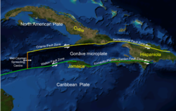
Mid-Cayman spreading centre as part of the trough, on the western edge of the Gonâve Microplate.

The Cayman Trough (also known as the Cayman Trench, Bartlett Deep and Bartlett Trough) is a complex transform fault zone pull-apart basin which contains a small spreading ridge, the Mid-Cayman Rise, on the floor of the western Caribbean Sea between Jamaica and the Cayman Islands.[1] It is the deepest point in the Caribbean Sea and forms part of the tectonic boundary between the North American Plate and the Caribbean Plate. It extends from the Windward Passage, going south of the Sierra MaestraofCuba toward Guatemala. The transform fault continues onshore as the Polochic-Motagua fault system, which consists of the Polochic and Motagua faults.[2] This system continues on until the Chiapas massif where it is part of the diffuse triple junction of the North American, Caribbean and Cocos plates.[3]

The relatively narrow trough trends east-northeast to west-southwest and has a maximum depth of 7,686 metres (25,217 ft). Within the trough is a slowly spreading north–south ridge which may be the result of an offset or gap of approximately 420 kilometres (260 mi) along the main fault trace. The Cayman spreading ridge shows a long-term opening rate of 11–12 mm/yr.[4] The eastern section of the trough has been named the Gonâve Microplate. The Gonâve plate extends from the spreading ridge east to the island of Hispaniola. It is bounded on the north by the Oriente and Septentrional fault zones. On the south the Gonâve is bounded by the Walton fault zone, the Jamaica restraining bend and the Enriquillo-Plantain Garden fault zone. The two bounding strike slip fault zones are left lateral. The motion relative to the North American Plateis11 mm/yr to the east and the motion relative to the Caribbean Plate is 8 mm/yr.[4] The western section of the trough is bounded to its south by the Swan Islands Transform Fault.[5]

During the Eocene the trough was the site of a subduction zone which formed the volcanic arc of the Cayman Ridge and the Sierra Maestra volcanic terrain of Cuba to the north, as the northeastward-moving Caribbean Plate was subducted beneath the southwest-moving North American Plate, or as some researchers contend, beneath a plate fragment dubbed the East Cuban Microplate.[6][failed verification]

In 2010 a UK team from the National Oceanography CentreinSouthampton (NOCS), equipped with an autonomously controlled robot submarine, began mapping the full extent of the trench and discovered black smokers on the ocean floor at a depth of 5 km (16,000 ft), the deepest yet found.[7][8][9] In January 2012, the researchers announced that water exits the vents at a temperature possibly exceeding 450 °C (842 °F), making them among the hottest known undersea vents. They also announced the discovery of new species, including an eyeless shrimp with a light-sensing organ on its back.[10]

See also[edit]

References[edit]

  1. ^ Einsele, Gerhard (2000). Sedimentary Basins: Evolution, Facies, and Sediment Budget (2nd ed.). Springer. p. 630. ISBN 978-3-540-66193-1.
  • ^ Lyon-Caen, H.; Barrier, E.; Lasserre, C.; Fraco, A.; Arzu, I.; Chiquin, L.; Chiquin, M.; Duquesnoy, T.; Flores, O.; Galicia, O.; Luna, J.; Molina, E.; Porras, O.; Requena, J.; Robles, V.; Romero, J.; Wolf, R. (2006). "Kinematics of the North American-Caribbean-Cocos plates in Central America from new GPS measurements across the Polochic-Motagua fault system". Geophysical Research Letters. 33 (L19309). Bibcode:2006GeoRL..3319309L. doi:10.1029/2006GL027694. S2CID 3161221.
  • ^ Guzmán-Speziale, Marco (2010). "Beyond the Motagua and Polochic faults: Active strike-slip faulting along the Western North America-Caribbean plate boundary zone". Tectonophysics. 496 (1–4): 17–27. Bibcode:2010Tectp.496...17G. doi:10.1016/j.tecto.2010.10.002.
  • ^ a b DeMets, C.; Wiggins-Grandison, M. (2007). "Deformation of Jamaica and motion of the Gonâve microplate from GPS and seismic data". Geophys. J. Int. 168 (1): 375–6. Bibcode:2007GeoJI.168..362D. doi:10.1111/j.1365-246x.2006.03236.x.
  • ^ Rosencrantz M.; Mann P. (1991). "SeaMARC II mapping of transform faults in the Cayman Trough, Caribbean Sea". Geology. 19 (7): 690–691. Bibcode:1991Geo....19..690R. doi:10.1130/0091-7613(1991)019<0690:SIMOTF>2.3.CO;2.
  • ^ Sigurdsson, H; S. Kelley; R.M. Leckie; S. Carey; T. Bralower; J. King (2000). "Chapter 20: History of circum-Caribbean explosive volcanism: 40Ar/39Ar dating of tephra layers". In Leckie, R.M.; Sigurdsson, H.; Acton, G.D.; Draper, G. (eds.). Sci. Results. Proc. ODP. Vol. 165. College Station, Texas: Ocean Drilling Program. doi:10.2973/odp.proc.sr.165.2000. ISSN 1096-7451.
  • ^ Carpenter, Jennifer (August 9, 2008). "Sub to make deep Caribbean dive". BBC Science News. Retrieved August 9, 2008.
  • ^ "World's deepest undersea vents discovered". LiveScience.com. April 11, 2010. Retrieved April 12, 2010.
  • ^ "Latest news". RRS James Cook Voyage 44. Retrieved January 14, 2012.
  • ^ McGrath, Matt (January 12, 2012). "Cayman vents are world's hottest". BBC News. Retrieved January 14, 2012.
  • Further reading[edit]

    18°30′N 83°0′W / 18.500°N 83.000°W / 18.500; -83.000


    Retrieved from "https://en.wikipedia.org/w/index.php?title=Cayman_Trough&oldid=1220819377"

    Categories: 
    Landforms of Cuba
    Extreme points of Jamaica
    Landforms of the Cayman Islands
    Oceanic trenches of the Caribbean Sea
    Plate tectonics
    CubaJamaica border
    Borders of the Cayman Islands
    Pull-apart basins
    Structural basins
    Tectonic landforms
    Seismic faults of North America
    Hidden categories: 
    Pages using gadget WikiMiniAtlas
    Articles with short description
    Short description is different from Wikidata
    All articles with failed verification
    Articles with failed verification from December 2019
    Coordinates on Wikidata


    This page was last edited on 26 April 2024, at 03:05 (UTC).

    Text is available under the Creative Commons Attribution-ShareAlike License 4.0; additional terms may apply. By using this site, you agree to the Terms of Use and Privacy Policy. Wikipedia® is a registered trademark of the Wikimedia Foundation, Inc., a non-profit organization.


    Privacy policy

    About Wikipedia

    Disclaimers

    Contact Wikipedia

    Code of Conduct

    Developers

    Statistics

    Cookie statement

    Mobile view


    Wikimedia Foundation
    Powered by MediaWiki