Jump to content


Main menu


Navigation  


Main page
Contents
Current events
Random article
About Wikipedia
Contact us
Donate


Contribute  


Help
Learn to edit
Community portal
Recent changes
Upload file


Search  


Create account

Log in


Create account
 Log in


Pages for logged out editors learn more  


Contributions
Talk


Contents


(Top)


1 Location and description  


2 Climate  


3 Flora and fauna  


4 See also  


5 References  


Central Tibetan Plateau alpine steppe


Українська
 

Edit links


Article
Talk


Read
Edit
View history


Tools


Actions  


Read
Edit
View history


General  


What links here
Related changes
Upload file
Special pages
Permanent link
Page information
Cite this page
Get shortened URL
Download QR code
Wikidata item


Print/export  


Download as PDF
Printable version


In other projects  


Wikimedia Commons


Appearance


Coordinates: 34°00N 92°00E / 34.000°N 92.000°E / 34.000; 92.000
 

From Wikipedia, the free encyclopedia


Central Tibetan Plateau alpine steppe
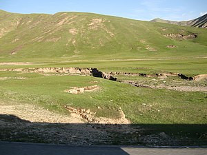
Qinghai-Tibet Plateau, in the east of the ecoregion
Ecoregion territory (in purple)
Ecology
RealmPalearctic
BiomeMontane grasslands and shrublands
Geography
Area629,626 km2 (243,100 sq mi)
CountriesChina
Coordinates34°00′N 92°00′E / 34.000°N 92.000°E / 34.000; 92.000

The Central Tibetan Plateau alpine steppe ecoregion (WWF ID: PA1002) covers the high alpine plateau that stretches over 1,600 kilometres (1,000 mi) across the Tibetan PlateautoQinghai Lake in China. Because of the high altitude—much it over 5,000 metres (16,000 ft)—the region is a cold, arid desert that is only 20% covered with steppe and meadow vegetation. The area has been relatively free from human development due to the hostile climate and unsuitability for agriculture. The ecosystem is relatively intact, and supports herds of wild antelope, sheep, deer, and gazelles.[1][2]

Location and description[edit]

Towards the west, the ecoregion is on the southern Changtang plateau, a part of the greater Qinghai-Tibet Plateau. This area is a high basin between the even higher Kunlun Mountains to the north and the Himalayas to the south. The plateau tilts gently down towards the southeast, with elevations of 6,000 meters on the Changtang in the northwest to 3,200 meters at Qingai Lake in Qinghai. The terrain is generally rolling plains. At wide intervals are shallow, brackish lakes.

Climate[edit]

The climate of most of the ecoregion is Tundra climate (Köppen climate classification ET), characterized as a climate in which at least one month has an average temperature high enough to melt snow (0 °C or 32 °F), but no month with an average temperature over (10 °C or 50 °F).[3][4] Precipitation ranges from 400 mm/year in the northwest to 200 mm/year in the southeast.

Flora and fauna[edit]

Vegetation zones in the region are greatly affected by elevation and precipitation, but are generally sparsely covered. Precipitation controls which alpine zones will have meadow, steppe, or cold desert vegetation Higher steppe elevations support sedges (Carex), with purple feathergrass (Stipa purpurea) increasing in lower altitudes. Wetter areas will support cushion plants and some woody forbs, but there are no trees on the plateau. Small stands of brush and trees can be found in the low, southern river valleys.[1]

The area supports herds of wild Tibetan antelope, Chinese blue sheep (Bharal), several species of deer, and gazelles.[1]

See also[edit]

References[edit]

  1. ^ a b c "Central Tibetan Plateau alpine steppe". World Wildlife Federation (WWF). Retrieved December 28, 2019.
  • ^ "Map of Ecoregions 2017". Resolve, using WWF data. Retrieved September 14, 2019.
  • ^ Kottek, M.; Grieser, J.; Beck, C.; Rudolf, B.; Rubel, F. (2006). "World Map of Koppen-Geiger Climate Classification Updated" (PDF). Gebrüder Borntraeger 2006. Retrieved September 14, 2019.
  • ^ "Dataset - Koppen climate classifications". World Bank. Retrieved September 14, 2019.

  • Retrieved from "https://en.wikipedia.org/w/index.php?title=Central_Tibetan_Plateau_alpine_steppe&oldid=1212798305"

    Categories: 
    Ecoregions of China
    Montane grasslands and shrublands
    Palearctic ecoregions
    Hidden categories: 
    Pages using gadget WikiMiniAtlas
    Articles with short description
    Short description is different from Wikidata
    Coordinates on Wikidata


    This page was last edited on 9 March 2024, at 16:55 (UTC).

    Text is available under the Creative Commons Attribution-ShareAlike License 4.0; additional terms may apply. By using this site, you agree to the Terms of Use and Privacy Policy. Wikipedia® is a registered trademark of the Wikimedia Foundation, Inc., a non-profit organization.


    Privacy policy

    About Wikipedia

    Disclaimers

    Contact Wikipedia

    Code of Conduct

    Developers

    Statistics

    Cookie statement

    Mobile view


    Wikimedia Foundation
    Powered by MediaWiki