Jump to content


Main menu


Navigation  


Main page
Contents
Current events
Random article
About Wikipedia
Contact us
Donate


Contribute  


Help
Learn to edit
Community portal
Recent changes
Upload file


Search  


Create account

Log in


Create account
 Log in


Pages for logged out editors learn more  


Contributions
Talk


Contents


(Top)


1 See also  


2 References  


Chamlang


Azərbaycanca
Беларуская
Català
Cebuano
Čeština
Dansk
Deutsch
فارسی
Français
ि
Italiano
Ladin
Bahasa Melayu

Norsk nynorsk
Oʻzbekcha / ўзбекча
پنجابی
Polski
Русский
Svenska
ி
Українська


Edit links


Article
Talk


Read
Edit
View history


Tools


Actions  


Read
Edit
View history


General  


What links here
Related changes
Upload file
Special pages
Permanent link
Page information
Cite this page
Get shortened URL
Download QR code
Wikidata item


Print/export  


Download as PDF
Printable version


In other projects  


Wikimedia Commons


Appearance


Coordinates: 27°4632N 86°5847E / 27.77556°N 86.97972°E / 27.77556; 86.97972
 

From Wikipedia, the free encyclopedia


Chamlang
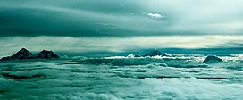
From left to right: the peaks of Mount Everest and Lhotse, then Makalu, and Chamlang on the right side.
Highest point
Elevation7,319 m (24,012 ft)[1]
Ranked 80th
Prominence1,193 m (3,914 ft)[1]
ListingMountains of Nepal
Coordinates27°46′32N 86°58′47E / 27.77556°N 86.97972°E / 27.77556; 86.97972[2]
Geography
Chamlang is located in Koshi Province
Chamlang

Chamlang

Location in Nepal

Chamlang is located in Nepal
Chamlang

Chamlang

Chamlang (Nepal)

LocationNepal
Parent rangeMahalangur, Himalayas
Climbing
First ascent31 May 1962[3]

Chamlang is a mountain in the Nepalese Himalayas, near Makalu. It lies in the southern section of the Mahalangur subrange of the Himalayas. Chamlang has an elevation of 7,319 metres (24,012 ft).


In 2021 a new, direct line up the sheer north face was climbed by two French mountain guides, Charles Dubouloz and Benjamin Vedrines. Climbing just as a pair, the route, which they named 'In the Shadow of Lies', took them four days to complete and included ice up to 90°.[4]


See also

[edit]

References

[edit]
  1. ^ a b "Chamlang, Nepal". Peakbagger.com. Retrieved 2012-01-08.
  • ^ "Chamlang". Peakware.com. Archived from the original on 2016-03-04. Retrieved 2012-01-08.
  • ^ Seiki Nakano, Academic Alpine Club of Hokkaido (1963). "Asia, Nepal, Chamlang". Climbs and Expeditions. American Alpine Journal. 13: 518–519. Retrieved 14 October 2017.
  • ^ Benavides, Angela (19 October 2021). "Interview with Charles Duvouloz: A New Route On Chamlang". Explorersweb. Retrieved 20 October 2021.

  • t
  • e

  • Retrieved from "https://en.wikipedia.org/w/index.php?title=Chamlang&oldid=1197138331"

    Categories: 
    Seven-thousanders of the Himalayas
    Mountains of Koshi Province
    Nepal mountain stubs
    Hidden categories: 
    Pages using gadget WikiMiniAtlas
    Articles with short description
    Short description is different from Wikidata
    Coordinates on Wikidata
    All stub articles


    This page was last edited on 19 January 2024, at 11:06 (UTC).

    Text is available under the Creative Commons Attribution-ShareAlike License 4.0; additional terms may apply. By using this site, you agree to the Terms of Use and Privacy Policy. Wikipedia® is a registered trademark of the Wikimedia Foundation, Inc., a non-profit organization.


    Privacy policy

    About Wikipedia

    Disclaimers

    Contact Wikipedia

    Code of Conduct

    Developers

    Statistics

    Cookie statement

    Mobile view


    Wikimedia Foundation
    Powered by MediaWiki