Jump to content


Main menu


Navigation  


Main page
Contents
Current events
Random article
About Wikipedia
Contact us
Donate


Contribute  


Help
Learn to edit
Community portal
Recent changes
Upload file


Search  


Create account

Log in


Create account
 Log in


Pages for logged out editors learn more  


Contributions
Talk


Contents


(Top)


1 Geography  


2 Demographics  


3 People  


4 See also  


5 References  


Change Islands


فارسی
Français
Nederlands
Português
Українська
 

Edit links


Article
Talk


Read
Edit
View history


Tools


Actions  


Read
Edit
View history


General  


What links here
Related changes
Upload file
Special pages
Permanent link
Page information
Cite this page
Get shortened URL
Download QR code
Wikidata item


Print/export  


Download as PDF
Printable version


In other projects  


Wikimedia Commons


Appearance


Coordinates: 49°4019N 54°2428W / 49.67194°N 54.40790°W / 49.67194; -54.40790 (Change Islands)
 

From Wikipedia, the free encyclopedia


Change Islands
Town
Change Islands is located in Newfoundland
Change Islands

Change Islands

Location of Change Islands in Newfoundland

Coordinates: 49°40′19N 54°24′28W / 49.67194°N 54.40790°W / 49.67194; -54.40790 (Change Islands)
Country Canada
Province Newfoundland and Labrador
SettledMid-18th century
Area
 • Land5.31 km2 (2.05 sq mi)
Population
 (2021)[2]
 • Total184
 • Density39.2/km2 (102/sq mi)
Time zoneUTC-3:30 (Newfoundland Time)
 • Summer (DST)UTC-2:30 (Newfoundland Daylight)
Area code709
Highways MV Veteran
Websitechangeislands.ca

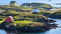
Change Islands is an outport community in the Canadian provinceofNewfoundland and Labrador.

The community spans two small islands of the same name which lie off the northeast coast of the island of Newfoundland between Notre Dame Bay and the Labrador Sea.

The community of Change Islands is located primarily on the larger South Island, today hosting approximately 184 residents, though most of the public buildings are on the North Island.

The Newfoundland Pony Refuge is located on Change Islands.

Geography

[edit]

The southern and northern Change Islands are separated by a "tickle" (a narrow strait, in Newfoundland English).

The South Island is larger, containing more marshes/bogs, and wooded area, the North Island is smaller, mostly barren. It is located in Notre Dame Bay, on the northeast coast of the island of Newfoundland.

The community was first established as a series of random settlements around the islands tied to seasonal fishing activity which developed into a cohesive community, but by the early 1960s only Red Rock Cove (at the middle of the southern island) and Woody Island Tickle (approximately at the ferry terminal at the south of the southern island) remained. Most of the remaining settlements (Granpher's Cove, etc.) on either side of the tickle effectively incorporated into one entity. Remoter places (Gannis Island, etc.) were gradually abandoned. The first European settlers arrived sometime in the mid-18th century to fish.

The residents of Change Islands have preserved many of their traditional homes, stages, and stores (fishing sheds); many of these landmarks are disappearing in much of coastal Newfoundland and Labrador with the collapse of the ground fishery.

There are a few accommodation facilities on the islands, which are accessible by the MVVeteran, the provincially operated ferry from Farewell that also services Fogo Island further to the east.[3]

A view of the tickle in Change Islands

Demographics

[edit]

In the 2021 Census of Population conducted by Statistics Canada, Change Islands had a population of 184 living in 104 of its 204 total private dwellings, a change of -11.5% from its 2016 population of 208. With a land area of 5.36 km2 (2.07 sq mi), it had a population density of 34.3/km2 (88.9/sq mi) in 2021.[2]

People

[edit]

See also

[edit]

References

[edit]
  1. ^ "Census Profile, 2016 Census Change Islands, Town [Census subdivision], Newfoundland and Labrador". Statistics Canada. 8 February 2017. Retrieved October 25, 2019.
  • ^ a b "Population and dwelling counts: Canada, provinces and territories, census divisions and census subdivisions (municipalities), Newfoundland and Labrador". Statistics Canada. February 9, 2022. Retrieved March 15, 2022.
  • ^ "N.L. ferries made 4,100 trips with no passengers last year". CBC. 2020-05-15. Retrieved 2020-12-17.
  • ^ "Gerald Squires’ humble beginnings". Gander Beacon, Clarence Ngoh, Oct 02, 2017

  • Retrieved from "https://en.wikipedia.org/w/index.php?title=Change_Islands&oldid=1218330619"

    Categories: 
    Islands of Newfoundland and Labrador
    Towns in Newfoundland and Labrador
    Road-inaccessible communities of Newfoundland and Labrador
    Islands of the Labrador Sea
    Fishing communities in Canada
    Hidden categories: 
    Pages using gadget WikiMiniAtlas
    Use Canadian English from January 2023
    All Wikipedia articles written in Canadian English
    Articles with short description
    Short description matches Wikidata
    Coordinates on Wikidata


    This page was last edited on 11 April 2024, at 02:22 (UTC).

    Text is available under the Creative Commons Attribution-ShareAlike License 4.0; additional terms may apply. By using this site, you agree to the Terms of Use and Privacy Policy. Wikipedia® is a registered trademark of the Wikimedia Foundation, Inc., a non-profit organization.


    Privacy policy

    About Wikipedia

    Disclaimers

    Contact Wikipedia

    Code of Conduct

    Developers

    Statistics

    Cookie statement

    Mobile view


    Wikimedia Foundation
    Powered by MediaWiki