
Changyang Tujia Autonomous County
Changyang County
长阳县 | |
|---|---|
| 长阳土家族自治县 Changyang Tujia Autonomous County | |
 Longzhou Boulevard | |
 Changyang Location in Hubei | |
| Coordinates: 30°28′N 110°52′E / 30.467°N 110.867°E | |
| Country | People's Republic of China |
| Province | Hubei |
| Prefecture-level city | Yichang |
| Area | |
| • Total | 3,430 km2 (1,320 sq mi) |
| Population (2010)[1] | |
| • Total | 388,228 |
| • Density | 110/km2 (290/sq mi) |
| Time zone | UTC+8 (China Standard) |
| Website | changyang |
Changyang Tujia Autonomous County (simplified Chinese: 长阳土家族自治县; traditional Chinese: 長陽土家族自治縣; pinyin: Chángyáng Tǔjiāzú Zìzhìxiàn) or in Tujia language known as Changryangf Bifzivkar Zivzirxianf is an autonomous county in western Hubei province, People's Republic of China. It is under the administration of the prefecture-level city of Yichang.
The county is located in the basin of the Qing River, a right tributary of the Yangtze. The river is flanked by mountains on both sides, the tallest of which - the Tianzhu Mountain - is 2,542 metres (8,340 ft) tall. The river is dammed by the Geheyan Dam (located within the county) and the Gaoba Dam (located in the neighboring Yidu County-level City, but flooding some of the Qingjiang River valley within Changyang County as well). The resulting reservoirs provide the main water transportation route throughout much of the county.
Established in 1984 with a surface area of 3,412 square kilometres (1,317 sq mi) and a population in 1984 of 399,000 inhabitants, of which 295,000 were Tujia.[2]
Administrative divisions
[edit]- Longzhouping (龙舟坪镇), Gaojiayan (高家堰镇), Moshi (磨市镇), Duzhenwan (都镇湾镇), Ziqiu (资丘镇), Yuxiakou (渔峡口镇), Langping (榔坪镇), Hejiaping (贺家坪镇)
Three townships:
Climate
[edit]| Climate data for Changyang (1991–2020 normals, extremes 1981–2010) | |||||||||||||
|---|---|---|---|---|---|---|---|---|---|---|---|---|---|
| Month | Jan | Feb | Mar | Apr | May | Jun | Jul | Aug | Sep | Oct | Nov | Dec | Year |
| Record high °C (°F) | 22.9 (73.2) |
29.0 (84.2) |
33.5 (92.3) |
37.9 (100.2) |
39.8 (103.6) |
40.1 (104.2) |
40.8 (105.4) |
41.1 (106.0) |
39.9 (103.8) |
35.0 (95.0) |
28.8 (83.8) |
25.1 (77.2) |
41.1 (106.0) |
| Mean daily maximum °C (°F) | 8.8 (47.8) |
11.6 (52.9) |
16.7 (62.1) |
22.9 (73.2) |
26.9 (80.4) |
30.0 (86.0) |
32.5 (90.5) |
32.2 (90.0) |
27.9 (82.2) |
22.6 (72.7) |
16.8 (62.2) |
11.3 (52.3) |
21.7 (71.0) |
| Daily mean °C (°F) | 5.0 (41.0) |
7.3 (45.1) |
11.6 (52.9) |
17.1 (62.8) |
21.4 (70.5) |
24.9 (76.8) |
27.4 (81.3) |
26.9 (80.4) |
22.8 (73.0) |
17.6 (63.7) |
12.2 (54.0) |
7.1 (44.8) |
16.8 (62.2) |
| Mean daily minimum °C (°F) | 2.2 (36.0) |
4.2 (39.6) |
7.9 (46.2) |
13.0 (55.4) |
17.4 (63.3) |
21.3 (70.3) |
23.8 (74.8) |
23.4 (74.1) |
19.5 (67.1) |
14.4 (57.9) |
9.2 (48.6) |
4.2 (39.6) |
13.4 (56.1) |
| Record low °C (°F) | −4.9 (23.2) |
−3.5 (25.7) |
−1.3 (29.7) |
2.3 (36.1) |
9.3 (48.7) |
12.7 (54.9) |
17.0 (62.6) |
15.8 (60.4) |
12.1 (53.8) |
3.4 (38.1) |
−1.2 (29.8) |
−4.1 (24.6) |
−4.9 (23.2) |
| Average precipitation mm (inches) | 34.9 (1.37) |
44.0 (1.73) |
69.0 (2.72) |
120.9 (4.76) |
164.3 (6.47) |
182.1 (7.17) |
250.5 (9.86) |
191.1 (7.52) |
105.0 (4.13) |
88.6 (3.49) |
56.0 (2.20) |
22.0 (0.87) |
1,328.4 (52.29) |
| Average precipitation days (≥ 0.1 mm) | 8.8 | 9.8 | 12.5 | 13.5 | 14.6 | 14.3 | 15.5 | 13.9 | 11.4 | 11.3 | 9.9 | 8.0 | 143.5 |
| Average snowy days | 4.0 | 2.9 | 1.0 | 0 | 0 | 0 | 0 | 0 | 0 | 0 | 0.3 | 1.0 | 9.2 |
| Average relative humidity (%) | 77 | 77 | 77 | 78 | 79 | 82 | 83 | 82 | 80 | 80 | 81 | 77 | 79 |
| Mean monthly sunshine hours | 68.6 | 73.5 | 107.2 | 130.5 | 136.2 | 132.7 | 166.7 | 171.1 | 121.2 | 110.9 | 95.2 | 82.9 | 1,396.7 |
| Percent possible sunshine | 21 | 23 | 29 | 34 | 32 | 31 | 39 | 42 | 33 | 32 | 30 | 26 | 31 |
| Source: China Meteorological Administration[5][6] | |||||||||||||
Transportation
[edit]The new Yichang-Wanzhou Railway crosses the northwestern part of the county, with two stations - Langping and Hejiaping - located near the eponymous towns of the county.
The China National Highway 318, and the newly constructed Shanghai-Chongqing Expressway (G50) run roughly parallel to the railway. Building the expressway in this area required the construction of a number of tunnels and remarkable bridges, such as the Longtanhe Bridge just outside Langping Town.[7]
-
 Changyang Square
 -
 Old street
 -
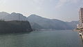 Qing River
 -
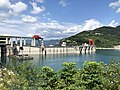 Geheyan Dam
 -
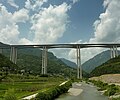 Longtanhe Bridge
 -
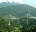 Tieluoping bridge, west of Langping town


References
[edit]1996年,长阳土家族自治县面积343
0平方千米,{...}2010年第六次人口普查,长阳土家族自治
县常住总人口388228人,其中‥龙舟坪镇89679人,高家堰
镇20590人,磨市镇29832人,都镇湾镇49755人,资丘
镇37651人,渔峡口镇33524人,榔坪镇39348人,贺家
坪镇27170人,大堰乡32839人,鸭子口乡20087人,火
烧坪乡7753人。(二)^ "Autonomous Administration of the Tujia". (三)^ 2017年统计用区划代码和城乡划分代码‥长阳土家族自治县 [2017 Statistical Area Numbers and Rural-Urban Area Numbers: Changyang Tujia Autonomous County]. National Bureau of Statistics of the People's Republic of China. 2017. Retrieved 10 November 2018.
统计用区划代码 名称 4205281010
00 龙舟坪镇 420528102000 高家堰镇 42052
8103000 磨市镇 420528104000 都镇湾镇 4
20528105000 资丘镇 420528106000 渔峡
口镇 420528107000 榔坪镇 42052810800
0 贺家坪镇 420528201000 大堰乡 4205282
02000 鸭子口乡 420528203000 火烧坪乡(四)^ 历史沿革 [Historical Development]. “中国 • 长阳”政府门户网 (in Chinese). 长阳土家族自治县人民政府, 长阳县电子政务办公室. 15 September 2017. Archived from the original on 4 December 2018. Retrieved 10 November 2018.
现辖8镇︵
龙舟坪、磨市、都镇湾、资丘、渔峡口、榔坪、贺家坪、高家堰︶3乡
︵大堰、鸭子口、火烧坪︶、154个行政村和8个社区。(五)^ 中国气象数据网 – WeatherBk Data (in Simplified Chinese). China Meteorological Administration. Retrieved 23 September 2023. (六)^ 中国气象数据网 (in Simplified Chinese). China Meteorological Administration. Retrieved 23 September 2023. (七)^ Longtanhe River Viaduct Archived 2012-05-10 at the Wayback Machine
| International |
|
|---|---|
| National |
|
This Hubei location article is a stub. You can help Wikipedia by expanding it. |