Jump to content


Main menu


Navigation  


Main page
Contents
Current events
Random article
About Wikipedia
Contact us
Donate


Contribute  


Help
Learn to edit
Community portal
Recent changes
Upload file


Search  


Create account

Log in


Create account
 Log in


Pages for logged out editors learn more  


Contributions
Talk


Contents


(Top)


1 Stratigraphy  


2 Subdivisions  


3 References  


4 Further reading  


Chapel Island Formation


Español
 

Edit links


Article
Talk


Read
Edit
View history


Tools


Actions  


Read
Edit
View history


General  


What links here
Related changes
Upload file
Special pages
Permanent link
Page information
Cite this page
Get shortened URL
Download QR code
Wikidata item


Print/export  


Download as PDF
Printable version


Appearance


From Wikipedia, the free encyclopedia


Chapel Island Formation
Stratigraphic range: Ediacaran – Fortunian[1]

O

S

D

C

P

T

J

K

Pg

N

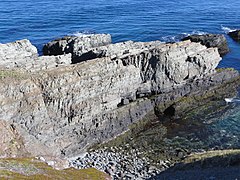
Ediacaran–Cambrian boundary section at Fortune Head, Newfoundland, in the Chapel Island Formation. The darker units constituting the bottom 2–3 m of the outcrop correspond to Unit 1; the GSSP lies a couple of meters into Unit 2.
TypeFormation
Unit ofYoung's Cove Group[2]
UnderliesRandom Fm[3]
OverliesRencontre Fm[3]
ThicknessHundreds of metres[3]
Location
RegionNewfoundland
CountryCanada

Outcrop distribution in southeast Newfoundland

The Chapel Island Formation is a sedimentary formation from the Burin Peninsula, Newfoundland, Canada. It is a succession of siliciclastic deposits, over 1,000 metres (3,300 ft) thick, that were deposited during the latest Ediacaran and earliest Cambrian.

Stratigraphy

[edit]

The formation's sequence stratigraphy is detailed in a journal article by Myrow and Hiscott.[4] The formation starts in an intertidal zone, then, as the Cambrian progresses, becomes deeper water (outer shelf) as a general trend.

The Chapel Island Formation lies on top of the Rencontre Formation and below the Random Formation.[1] It is 900 metres (3,000 ft) thick in Fortune Bay as a fault-bounded basin, consisting of grey-green siltstones and sandstones, with minor limestone beds near its top. Small shelly fossils have been recovered – primitive taxa only. The setting is nearshore or open shelf.[3]

Subdivisions

[edit]

The formation is divided into six members, numbered 1 to 5, with Member 2 split into 2A and 2B. The ProterozoicCambrian boundary occurs 20.66 metres (67.8 ft) above the base of the formation, 2.4 metres (7.9 ft) into Member 2A.[1]

The lowest occurrence of Treptichnus pedum in the succession is 16.25 metres (53.3 ft) above the base of the unit.[1]

References

[edit]
  1. ^ a b c d Gehling, James G.; Jensen, Sören; Droser, Mary L.; Myrow, Paul M.; Narbonne, Guy M. (2001). "Burrowing below the basal Cambrian GSSP, Fortune Head, Newfoundland" (PDF). Geological Magazine. 138 (2): 213–218. Bibcode:2001GeoM..138..213G. doi:10.1017/S001675680100509X. Archived from the original (PDF) on 28 October 2014. Retrieved 3 November 2012.
  • ^ "Newfoundland and Labrador Geoscience Atlas".
  • ^ a b c d Smith, Simon A.; Hiscott, Richard N. (December 1984). "Latest Precambrian to Early Cambrian basin evolution, Fortune Bay, Newfoundland: fault-bounded basin to platform". Canadian Journal of Earth Sciences. 21 (12): 1379–1392. Bibcode:1984CaJES..21.1379S. doi:10.1139/e84-143.
  • ^ Myrow, Paul M.; Hiscott, Richard N. (September 1993). "Depositional history and sequence stratigraphy of the Precambrian-Cambrian boundary stratotype section, Chapel Island Formation, southeast Newfoundland". Palaeogeography, Palaeoclimatology, Palaeoecology. 104 (1–4): 13–35. doi:10.1016/0031-0182(93)90117-2.
  • Further reading

    [edit]


  • t
  • e

  • Retrieved from "https://en.wikipedia.org/w/index.php?title=Chapel_Island_Formation&oldid=1168683139"

    Categories: 
    Geologic formations of Newfoundland and Labrador
    Cambrian south paleopolar deposits
    Canadian geologic formation stubs
    Hidden categories: 
    Articles with short description
    Short description matches Wikidata
    All stub articles


    This page was last edited on 4 August 2023, at 09:30 (UTC).

    Text is available under the Creative Commons Attribution-ShareAlike License 4.0; additional terms may apply. By using this site, you agree to the Terms of Use and Privacy Policy. Wikipedia® is a registered trademark of the Wikimedia Foundation, Inc., a non-profit organization.


    Privacy policy

    About Wikipedia

    Disclaimers

    Contact Wikipedia

    Code of Conduct

    Developers

    Statistics

    Cookie statement

    Mobile view


    Wikimedia Foundation
    Powered by MediaWiki