Jump to content


Main menu


Navigation  


Main page
Contents
Current events
Random article
About Wikipedia
Contact us
Donate


Contribute  


Help
Learn to edit
Community portal
Recent changes
Upload file


Search  


Create account

Log in


Create account
 Log in


Pages for logged out editors learn more  


Contributions
Talk


Contents


(Top)


1 Photo gallery  


2 See also  


3 References  


4 External links  


Chaukhamba


Català
Cebuano
Čeština
Deutsch
Español
Français
ि
Ladin

مصرى

Svenska
Українська
 

Edit links


Article
Talk


Read
Edit
View history


Tools


Actions  


Read
Edit
View history


General  


What links here
Related changes
Upload file
Special pages
Permanent link
Page information
Cite this page
Get shortened URL
Download QR code
Wikidata item


Print/export  


Download as PDF
Printable version


In other projects  


Wikimedia Commons


Appearance


Coordinates: 30°4459N 79°1728E / 30.74972°N 79.29111°E / 30.74972; 79.29111
 

From Wikipedia, the free encyclopedia


Chaukhamba I
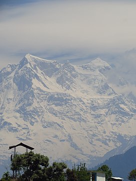
Chaukhamba peak as seen from Deoria Tal/LakeinChandrashila peak
Highest point
Elevation7,138 m (23,419 ft)[1]
Prominence1,594 m (5,230 ft)[2]
ListingUltra
Coordinates30°44′59N 79°17′28E / 30.74972°N 79.29111°E / 30.74972; 79.29111[3]
Geography
Chaukhamba is located in India
Chaukhamba

Chaukhamba

India

LocationUttarakhand, India
Parent rangeGangotri Group, Garhwal Himalaya
Climbing
First ascent13 June 1952, by Lucien George and Victor Russenberger[3][4]

Chaukhamba is a mountain massif in the Gangotri Group of the Garhwal Himalaya. Its main summit, Chaukhamba I, is the highest peak in the group. It lies at the head of the Gangotri Glacier and forms the eastern anchor of the group.[5] It is located in the northern Indian state of Uttarakhand, west of the Hindu holy town of Badrinath.

Chaukhamba has four summits, along a northeast–southwest trending ridge, and ranging in elevation from 7,138 metres (23,419 ft) to 6,854 m (22,487 ft) with an average elevation 7,014 m;[3] the main summit is at the northeast end.

Chaukamba I 7,138 m (23,419 ft)
Chaukamba II 7,070 m (23,196 ft)
Chaukamba III 6,995 m (22,949 ft)
Chaukamba IV 6,854 m (22,487 ft)

After unsuccessful attempts in 1938 and 1939, Chaukhamba I was first climbed on 13 June 1952, by Lucien George and Victor Russenberger (Swiss members of an otherwise French expedition). They ascended the northeast face, from the Bhagirathi-Kharak Glacier.[4] The other members of the expedition were the French alpinist and traveler Marie-Louise Plovier Chapelle and the renown French alpinist and climber Edouard Frendo.

Chaukhamba I is an ultra-prominent peak, with a prominence of more than 1,500m. Mana Pass is the key col for Chaukhamba I.

Mt Mandani and Chaukhamba with reflection on semi frozen lake at Boodha Madhyamaheshwar
Chaukhamba Massif from Bedni Bugyal
Chaukhamba View
Chaukhamba View From Kartik Swami Temple Rudraprayag

Photo gallery[edit]

See also[edit]

References[edit]

  1. ^ IMF Archived 11 October 2008 at the Wayback Machine
  • ^ "High Asia I: The Karakoram, Pakistan Himalaya and India Himalaya (north of Nepal)". Peaklist.org. Retrieved 28 May 2014.
  • ^ a b c Himalayan Index
  • ^ a b American Alpine Journal, 1953, pp. 581–582.
  • ^ Andy Fanshawe and Stephen Venables, Himalaya Alpine-Style, Hodder and Stoughton, 1995, ISBN 0-340-64931-3, p. 106.
  • External links[edit]


  • t
  • e

  • Retrieved from "https://en.wikipedia.org/w/index.php?title=Chaukhamba&oldid=1100145779"

    Categories: 
    Geography of Uttarkashi district
    Mountains of Uttarakhand
    Uttarakhand geography stubs
    Hidden categories: 
    Pages using gadget WikiMiniAtlas
    Webarchive template wayback links
    Articles with short description
    Short description matches Wikidata
    Use dmy dates from June 2019
    Use Indian English from July 2015
    All Wikipedia articles written in Indian English
    Coordinates on Wikidata
    Commons category link is on Wikidata
    Articles with VIAF identifiers
    Articles with GND identifiers
    All stub articles


    This page was last edited on 24 July 2022, at 12:00 (UTC).

    Text is available under the Creative Commons Attribution-ShareAlike License 4.0; additional terms may apply. By using this site, you agree to the Terms of Use and Privacy Policy. Wikipedia® is a registered trademark of the Wikimedia Foundation, Inc., a non-profit organization.


    Privacy policy

    About Wikipedia

    Disclaimers

    Contact Wikipedia

    Code of Conduct

    Developers

    Statistics

    Cookie statement

    Mobile view


    Wikimedia Foundation
    Powered by MediaWiki