Jump to content


Main menu


Navigation  


Main page
Contents
Current events
Random article
About Wikipedia
Contact us
Donate


Contribute  


Help
Learn to edit
Community portal
Recent changes
Upload file


Search  


Create account

Log in


Create account
 Log in


Pages for logged out editors learn more  


Contributions
Talk


Contents


(Top)


1 Route  


2 Tributaries  


3 Notes  


Chinnar River


ि
ி
 

Edit links


Article
Talk


Read
Edit
View history


Tools


Actions  


Read
Edit
View history


General  


What links here
Related changes
Upload file
Special pages
Permanent link
Page information
Cite this page
Get shortened URL
Download QR code
Wikidata item


Print/export  


Download as PDF
Printable version


In other projects  


Wikimedia Commons


Appearance


Coordinates: 10°212N 77°1414E / 10.35056°N 77.23722°E / 10.35056; 77.23722
 

From Wikipedia, the free encyclopedia


Chinnar River
Chinnar river and Pambar river merge to become Amaravati river
Location
CountryIdukki District, Kerala, India
Physical characteristics
Source 
 • locationAnamalai Hills
 • coordinates10°19′N 77°06′E / 10.317°N 77.100°E / 10.317; 77.100
 • elevation1,829 meters (6,001 ft)
Mouth 

 • location

Amaravati River

 • coordinates

10°21′2N 77°14′14E / 10.35056°N 77.23722°E / 10.35056; 77.23722

 • elevation

473 meters (1,552 ft)
Length18 km (11 mi)
Chinnar river from SH 17 border bridge between Tamil Nadu and kerala

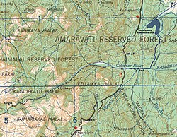
The Chinnar River originates in the Annaimalai Hills below a grassy pass between the hills Kumarikkal Mala (8,275 ft) and Kaladekatti MalaiInIdukki District, Kerala state South India. The 18 km long Chinnar river defines the East-West Tamil Nadu/Kerala state boundary along the northern edge of the Chinnar Wildlife Sanctuary and the southern edge of the Indira Gandhi Wildlife Sanctuary. Several adult crocodiles were reported in the Chinnar river in 1992.[1]

Route[edit]

The river first proceeds through a large shola then past the Muthuvar settlement of Olikkudi[2]at10°19′52N 77°08′37E / 10.331°N 77.1435°E / 10.331; 77.1435. There is another small village #2 at 10°21′19N 77°11′02E / 10.3553°N 77.1839°E / 10.3553; 77.1839. There are Kerala and Tamil Nadu border checkpoints on either side of the river where a SH 17 road bridge crosses the river at 10°21′09N 77°13′04E / 10.35241°N 77.21775°E / 10.35241; 77.21775. 2 km east it is joined from the south by the Pambar RiveratKoottar where a comfortable tree house accommodation is available.[3] Here it crosses into Indira Gandhi Wildlife Sanctuary in Tamil Nadu and becomes the Amaravati River.

Tributaries[edit]

The river is joined by a small stream from the south at a small village, 2. 2 km east of the NH 17 road bridge, while the river is joined from the south by the Pambar RiveratKoottar. The western part of the Manjampatti Valley catchment basin drains into the end of the Chinnar River. This Valley is drained by the stream Ten Ar and a smaller unnamed stream 2 km to its west. The unnamed stream is the N-S political boundary between Tamil Nadu and Kerala. The top of the ridge above this stream to the west is the western limit of the catchment. This unnamed stream joins the Pambar River at the point they both join the Chinnar River at the north west corner of the Valley.

Notes[edit]

  1. ^ SATHEESH, S (1992) - A preliminary status survey of the mugger crocodile (Crocodylus palustris, Lesson) in Tamil Nadu. Report submitted to the Centre for Herpetology/Madras Crocodile Bank. Table 2 "Status and Distribution of the Mugger Crocodile (Crocodylus Palustris) (Lesson) in Tamil Nadu, South India". Archived from the original on 20 December 2004. Retrieved 7 February 2016.
  • ^ S. V. Sajith Kumar, School of Social Sciences, Mahatma Gandhi University, Kottayam, Kerala, Ca_vat[i- A Case Study of Muthuvar Youth Dormitory System, Anthropologist, 7(1): 61-68 (2005) [1]
  • ^ Blue Yonder Holidays Pvt Ltd, Chinnar, the real treasure trove, retrieved 8/30/2007 Koottar Tree House Archived 15 October 2008 at the Wayback Machine.

  • Retrieved from "https://en.wikipedia.org/w/index.php?title=Chinnar_River&oldid=1152676647"

    Categories: 
    Rivers of Tamil Nadu
    Rivers of Idukki district
    Geography of Coimbatore
    Hidden categories: 
    Pages using gadget WikiMiniAtlas
    Webarchive template wayback links
    Articles with short description
    Short description is different from Wikidata
    Use dmy dates from February 2018
    Use Indian English from February 2018
    All Wikipedia articles written in Indian English
    Coordinates on Wikidata
    Commons category link is on Wikidata


    This page was last edited on 1 May 2023, at 16:52 (UTC).

    Text is available under the Creative Commons Attribution-ShareAlike License 4.0; additional terms may apply. By using this site, you agree to the Terms of Use and Privacy Policy. Wikipedia® is a registered trademark of the Wikimedia Foundation, Inc., a non-profit organization.


    Privacy policy

    About Wikipedia

    Disclaimers

    Contact Wikipedia

    Code of Conduct

    Developers

    Statistics

    Cookie statement

    Mobile view


    Wikimedia Foundation
    Powered by MediaWiki