Jump to content


Main menu


Navigation  


Main page
Contents
Current events
Random article
About Wikipedia
Contact us
Donate


Contribute  


Help
Learn to edit
Community portal
Recent changes
Upload file


Search  


Create account

Log in


Create account
 Log in


Pages for logged out editors learn more  


Contributions
Talk


Contents


(Top)


1 Geography  


1.1  Climate  


2 Population  


3 Transport  


4 Education  


5 Personalities  


6 International relations  


7 See also  


8 References  


9 External links  


Choisy-le-Roi


تۆرکجه
 / Bân-lâm-gú
Català
Чӑвашла
Cebuano
Čeština
Deutsch
Ελληνικά
Español
Esperanto
Euskara
فارسی
Français

Bahasa Indonesia
Italiano
Қазақша
Kiswahili
Ladin
Latina
Magyar
مازِرونی
Bahasa Melayu
Nederlands

Нохчийн
Norsk bokmål
Occitan
Polski
Português
Română
Русский
Simple English
Slovenčina
Slovenščina
Српски / srpski
Srpskohrvatski / српскохрватски
Suomi
Svenska
Татарча / tatarça
Türkçe
Українська
Vèneto
Tiếng Vit
Volapük
Winaray


Edit links


Article
Talk


Read
Edit
View history


Tools


Actions  


Read
Edit
View history


General  


What links here
Related changes
Upload file
Special pages
Permanent link
Page information
Cite this page
Get shortened URL
Download QR code
Wikidata item


Print/export  


Download as PDF
Printable version


In other projects  


Wikimedia Commons


Appearance


Coordinates: 48°4547N 2°2432E / 48.763°N 2.409°E / 48.763; 2.409
 

From Wikipedia, the free encyclopedia


Choisy-le-Roi
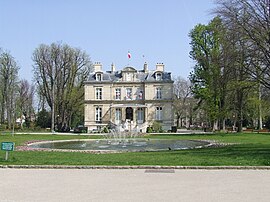
The town hall of Choisy-le-Roi
Coat of arms of Choisy-le-Roi
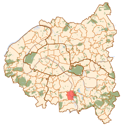
Paris and inner ring departments
Location of Choisy-le-Roi
Map
Choisy-le-Roi is located in France
Choisy-le-Roi

Choisy-le-Roi

Choisy-le-Roi is located in Île-de-France (region)
Choisy-le-Roi

Choisy-le-Roi

Coordinates: 48°45′47N 2°24′32E / 48.763°N 2.409°E / 48.763; 2.409
CountryFrance
RegionÎle-de-France
DepartmentVal-de-Marne
ArrondissementL'Haÿ-les-Roses
CantonChoisy-le-Roi
IntercommunalityGrand Paris
Government
 • Mayor (2020–2026) Tonino Panetta[1]
Area
1
5.43 km2 (2.10 sq mi)
Population
 (2021)[2]
46,129
 • Density8,500/km2 (22,000/sq mi)
Time zoneUTC+01:00 (CET)
 • Summer (DST)UTC+02:00 (CEST)
INSEE/Postal code
94022 /94600
Elevation31–49 m (102–161 ft)
(avg. 40 m or 130 ft)
1 French Land Register data, which excludes lakes, ponds, glaciers > 1 km2 (0.386 sq mi or 247 acres) and river estuaries.

Choisy-le-Roi (French pronunciation: [ʃwazi ʁwa] ) is a commune in the Val-de-Marne department, in the southeastern suburbs of Paris, Île-de-France.

Geography

[edit]

Choisy-le-Roi is located 10.7 km (6.6 mi) southeast from the center of Paris, on both banks of the river Seine. The neighbouring communes are, from the north and clockwise: Vitry-sur-Seine, Alfortville, Créteil, Valenton, Villeneuve-Saint-Georges, Orly and Thiais.

Climate

[edit]

Choisy-le-Roi has an oceanic climate (Köppen climate classification Cfb). The average annual temperature in Choisy-le-Roi is 12.7 °C (54.9 °F). The average annual rainfall is 607.2 mm (23.91 in) with December as the wettest month. The temperatures are highest on average in July, at around 21.0 °C (69.8 °F), and lowest in January, at around 5.3 °C (41.5 °F). The highest temperature ever recorded in Choisy-le-Roi was 41.7 °C (107.1 °F) on 25 July 2019; the coldest temperature ever recorded was −11.5 °C (11.3 °F) on 1 January 1997.

Climate data for Choisy-le-Roi (1991−2020 normals, extremes 1988−2021)
Month Jan Feb Mar Apr May Jun Jul Aug Sep Oct Nov Dec Year
Record high °C (°F) 16.0
(60.8)
21.2
(70.2)
26.2
(79.2)
29.6
(85.3)
33.3
(91.9)
37.5
(99.5)
41.7
(107.1)
40.5
(104.9)
35.3
(95.5)
28.9
(84.0)
21.0
(69.8)
17.0
(62.6)
41.7
(107.1)
Mean daily maximum °C (°F) 7.7
(45.9)
8.9
(48.0)
12.8
(55.0)
16.9
(62.4)
20.5
(68.9)
23.8
(74.8)
26.2
(79.2)
26.2
(79.2)
21.9
(71.4)
16.6
(61.9)
11.1
(52.0)
8.1
(46.6)
16.7
(62.1)
Daily mean °C (°F) 5.3
(41.5)
5.8
(42.4)
8.8
(47.8)
12.1
(53.8)
15.6
(60.1)
18.9
(66.0)
21.0
(69.8)
20.9
(69.6)
17.2
(63.0)
12.9
(55.2)
8.4
(47.1)
5.7
(42.3)
12.7
(54.9)
Mean daily minimum °C (°F) 2.8
(37.0)
2.7
(36.9)
4.8
(40.6)
7.3
(45.1)
10.7
(51.3)
13.9
(57.0)
15.8
(60.4)
15.6
(60.1)
12.5
(54.5)
9.2
(48.6)
5.6
(42.1)
3.3
(37.9)
8.7
(47.7)
Record low °C (°F) −11.5
(11.3)
−9.5
(14.9)
−7.0
(19.4)
−1.0
(30.2)
1.0
(33.8)
6.0
(42.8)
8.0
(46.4)
7.5
(45.5)
4.0
(39.2)
−1.0
(30.2)
−7.0
(19.4)
−8.0
(17.6)
−11.5
(11.3)
Average precipitation mm (inches) 49.5
(1.95)
43.3
(1.70)
43.3
(1.70)
44.7
(1.76)
58.6
(2.31)
54.5
(2.15)
53.0
(2.09)
52.5
(2.07)
43.2
(1.70)
51.6
(2.03)
52.7
(2.07)
60.3
(2.37)
607.2
(23.91)
Average precipitation days (≥ 1.0 mm) 10.8 9.6 9.7 8.6 9.2 8.4 7.4 7.6 7.5 9.7 10.9 12.1 111.3
Source: Météo-France[3]

Population

[edit]
Historical population
YearPop.±% p.a.
1793 1,150—    
1800 990−2.12%
1806 1,383+5.73%
1821 1,320−0.31%
1831 3,055+8.75%
1836 3,110+0.36%
1841 3,119+0.06%
1846 3,612+2.98%
1851 3,271−1.96%
1856 3,907+3.62%
1861 4,648+3.53%
1866 5,172+2.16%
1872 5,099−0.24%
1876 5,821+3.37%
1881 6,978+3.69%
1886 7,853+2.39%
1891 8,449+1.47%
1896 9,909+3.24%
YearPop.±% p.a.
1901 11,607+3.21%
1906 13,067+2.40%
1911 15,908+4.01%
1921 20,309+2.47%
1926 23,634+3.08%
1931 27,584+3.14%
1936 28,476+0.64%
1946 27,333−0.41%
1954 31,789+1.91%
1962 41,522+3.40%
1968 41,440−0.03%
1975 38,705−0.97%
1982 35,476−1.24%
1990 34,068−0.50%
1999 34,336+0.09%
2007 37,165+0.99%
2012 41,507+2.23%
2017 45,331+1.78%
Source: EHESS[4] and INSEE (1968-2017)[5]

Transport

[edit]

Choisy-le-Roi is served by Choisy-le-Roi station on Paris RER line C. It is also served by Créteil-Pompadour station on Paris RER line D.

Education

[edit]

Public schools include:[6]

There is a private school serving elementary to senior high school, groupe scolaire Saint André Choisy-le-Roi.[12]

Personalities

[edit]

International relations

[edit]

Choisy-le-Roi is twinned with:[13]

See also

[edit]

References

[edit]
  1. ^ "Répertoire national des élus: les maires". data.gouv.fr, Plateforme ouverte des données publiques françaises (in French). 2 December 2020.
  • ^ "Populations légales 2021" (in French). The National Institute of Statistics and Economic Studies. 28 December 2023.
  • ^ "Fiche Climatologique Statistiques 1991-2020 et records" (PDF). Météo-France. Retrieved August 24, 2022.
  • ^ Des villages de Cassini aux communes d'aujourd'hui: Commune data sheet Choisy-le-Roi, EHESS (in French).
  • ^ Population en historique depuis 1968, INSEE
  • ^ "Les établissements scolaires." Choisy-le-Roi. Retrieved on September 10, 2016.
  • ^ Home page. Collège Emile Zola. Retrieved on September 10, 2016.
  • ^ Collège Jules Vallès." Ministry of Education of France. Retrieved on September 10, 2016.
  • ^ Home. Collège Henri Matisse. Collège Paul Klee Retrieved on September 10, 2016.
  • ^ Home Archived 2016-09-14 at the Wayback Machine. Lycée Professionnel Jean Macé Choisy-le-Roi. Retrieved on September 10, 2016.
  • ^ Home. Lycée des métiers Jacques Brel. Retrieved on September 10, 2016.
  • ^ Home. Groupe scolaire Saint André Choisy-le-Roi. Retrieved on September 10, 2016.
  • ^ "Les jumelages". choisyleroi.fr (in French). Choisy-le-Roi. 16 October 2015. Retrieved 2019-11-20.
  • [edit]
    Retrieved from "https://en.wikipedia.org/w/index.php?title=Choisy-le-Roi&oldid=1231135856"

    Category: 
    Communes of Val-de-Marne
    Hidden categories: 
    Pages using gadget WikiMiniAtlas
    Pages using the Phonos extension
    Pages using the Graph extension
    Pages with disabled graphs
    CS1 French-language sources (fr)
    Articles with French-language sources (fr)
    Webarchive template wayback links
    Articles with short description
    Short description is different from Wikidata
    Coordinates on Wikidata
    Pages with French IPA
    Pages including recorded pronunciations
    Commons category link is on Wikidata
    Articles with VIAF identifiers
    Articles with WorldCat Entities identifiers
    Articles with BNF identifiers
    Articles with BNFdata identifiers
    Articles with GND identifiers
    Articles with J9U identifiers
    Articles with LCCN identifiers
    Articles with MusicBrainz area identifiers
    Articles with Mérimée identifiers
    Articles with SUDOC identifiers
    Pages using the Kartographer extension


    This page was last edited on 26 June 2024, at 17:33 (UTC).

    Text is available under the Creative Commons Attribution-ShareAlike License 4.0; additional terms may apply. By using this site, you agree to the Terms of Use and Privacy Policy. Wikipedia® is a registered trademark of the Wikimedia Foundation, Inc., a non-profit organization.


    Privacy policy

    About Wikipedia

    Disclaimers

    Contact Wikipedia

    Code of Conduct

    Developers

    Statistics

    Cookie statement

    Mobile view


    Wikimedia Foundation
    Powered by MediaWiki